Diezma elevation
Diezma (Andalusia, Provincia de Granada), Spain elevation is 1223 meters and Diezma elevation in feet is 4012 ft above sea level [src 1]. Diezma is a seat of a third-order administrative division (feature code) with elevation that is 620 meters (2034 ft) bigger than average city elevation in Spain.
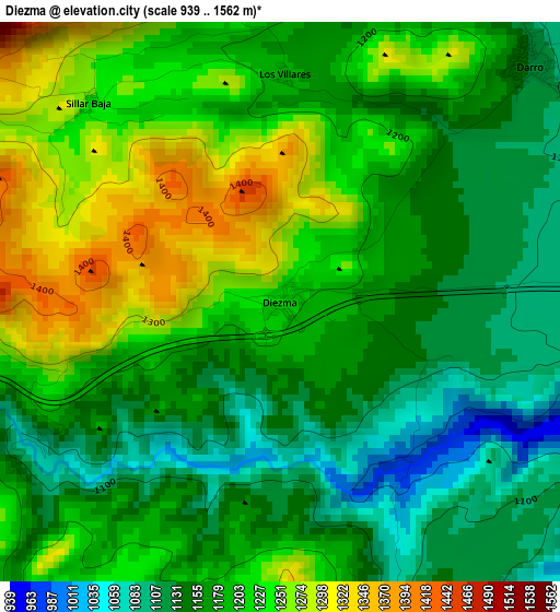
Below is the Elevation map of Diezma, which displays elevation range with different colors. Scale of the first map is from 939 to 1562 m (3081 to 5125 ft) with average elevation of 1189.4 meters (=3902 ft) [note 1]
These maps also provides idea of topography and contour of this city, they are displayed at different zoom levels. More info about maps, scale and edge coordinates you can find below images.
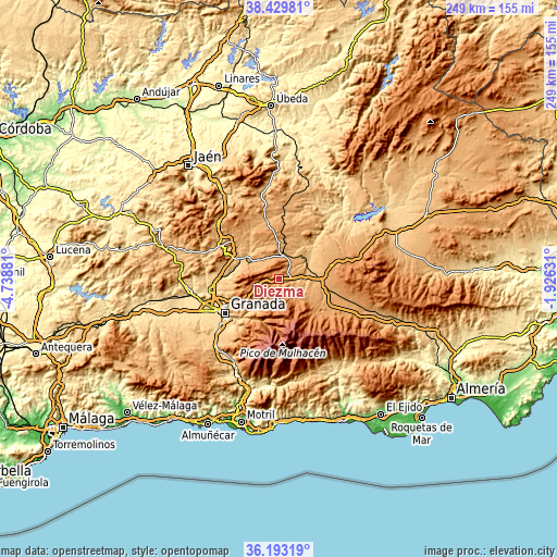
| \ | Map #1 | Topo.Map |
| Scale [m] | 939..1562 m | × |
| Scale [ft] | 3081..5125 ft | × |
| Average | 1189.4 m = 3902 ft | × |
| Width | 7.77 km = 4.8 mi | 248.7 km = 154.5 mi |
| Height | 7.77 km = 4.8 mi | 248.7 km = 154.5 mi |
| ↑Max Latitude | 37.35476° | 38.42981° |
| Latitude at center | 37.31982° | 37.31982° |
| ↓Min Latitude | 37.284864° | 36.19319° |
| ← Min Longitude | -3.376505° | -4.73881° |
| Longitude center | -3.33256° | -3.33256° |
| →Max Longitude | -3.288615° | -1.92631° |
Nearby cities:
Cities around Diezma sort by population:
• Guadix elevation 927 m
17.2 km,  97°
97°
• Benalúa de Guadix 874 m
15.3 km,  76°
76°
• Purullena 905 m
12.6 km,  91°
91°
• Darro 1133 m
4.7 km,  45°
45°
• Fonelas 773 m
17.4 km, 54°
• Piñar 902 m
16.7 km,  325°
325°
• Beas de Granada 1079 m
17.3 km,  229°
229°
• Huélago 920 m
12.7 km,  29°
29°
• Beas de Guadix 961 m
12.1 km,  112°
112°
• Marchal 937 m
11.7 km, 102°
• Lugros 1253 m
12.9 km,  141°
141°
• Polícar 1160 m
11.1 km,  128°
128°
Multilingual:
 En español:
Diezma elevación 1223 m.
 En France:
Diezma élévation 1223 m.


Sources and notes:
- [note 1] Map square and city borders are not equal. Map elevation data is calculated only from area inside that square.
- [src 1] Elevation data from geonames database provided with same terms of usage.
- [src 2] The elevation map of Diezma is generated using elevation data from NASA's 3 arcsec (90m) resolution SRTM data.
- [src 3] Base (background) map © OpenStreetMap contributors tiles are generated by Geofabrik and OpenTopoMap.
Copyright & License:
This Diezma Elevation Map is licensed under CC BY-SA. You may reuse any part from this page, if you give a proper credit by linking to this URL:
 More info on terms of use page.