Piñar elevation
Piñar (Andalusia, Provincia de Granada), Spain elevation is 902 meters and Piñar elevation in feet is 2959 ft above sea level [src 1]. Piñar is a populated place (feature code) with elevation that is 299 meters (981 ft) bigger than average city elevation in Spain.
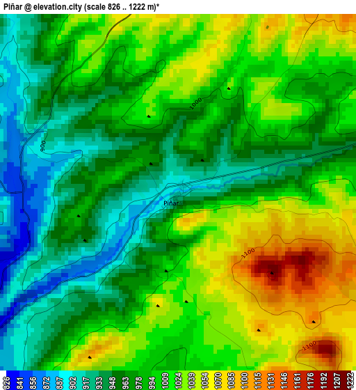
Below is the Elevation map of Piñar, which displays elevation range with different colors. Scale of the first map is from 826 to 1222 m (2710 to 4009 ft) with average elevation of 990.9 meters (=3251 ft) [note 1]
These maps also provides idea of topography and contour of this city, they are displayed at different zoom levels. More info about maps, scale and edge coordinates you can find below images.
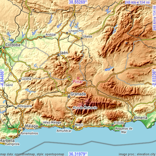
| \ | Map #1 | Topo.Map |
| Scale [m] | 826..1222 m | × |
| Scale [ft] | 2710..4009 ft | × |
| Average | 990.9 m = 3251 ft | × |
| Width | 7.76 km = 4.8 mi | 248.3 km = 154.3 mi |
| Height | 7.76 km = 4.8 mi | 248.3 km = 154.3 mi |
| ↑Max Latitude | 37.479452° | 38.55269° |
| Latitude at center | 37.44457° | 37.44457° |
| ↓Min Latitude | 37.409672° | 36.31979° |
| ← Min Longitude | -3.482555° | -4.84486° |
| Longitude center | -3.43861° | -3.43861° |
| →Max Longitude | -3.394665° | -2.03236° |
Nearby cities:
Cities around Piñar sort by population:
• Iznalloz elevation 818 m
9.8 km,  233°
233°
• Montejicar 1146 m
15.4 km,  337°
337°
• Deifontes 726 m
19.1 km, 226°
• Guadahortuna 964 m
13 km,  15°
15°
• Darro 1133 m
16.5 km,  129°
129°
• Campotéjar 923 m
16.4 km,  284°
284°
• Torre-Cardela 1218 m
9.9 km,  47°
47°
• Diezma 1223 m
16.7 km,  145°
145°
• Huélago 920 m
15.8 km,  100°
100°
• Gobernador 1038 m
11 km,  70°
70°
• Dehesas Viejas 1007 m
10.6 km,  288°
288°
• Domingo Pérez 970 m
8.5 km,  312°
312°
Multilingual:
 En español:
Piñar elevación 902 m.
 En France:
Piñar élévation 902 m.


Sources and notes:
- [note 1] Map square and city borders are not equal. Map elevation data is calculated only from area inside that square.
- [src 1] Elevation data from geonames database provided with same terms of usage.
- [src 2] The elevation map of Piñar is generated using elevation data from NASA's 3 arcsec (90m) resolution SRTM data.
- [src 3] Base (background) map © OpenStreetMap contributors tiles are generated by Geofabrik and OpenTopoMap.
Copyright & License:
This Piñar Elevation Map is licensed under CC BY-SA. You may reuse any part from this page, if you give a proper credit by linking to this URL:
 More info on terms of use page.