La Codosera elevation
La Codosera (Extremadura, Provincia de Badajoz), Spain elevation is 323 meters and La Codosera elevation in feet is 1060 ft above sea level [src 1]. La Codosera is a populated place (feature code) with elevation that is 280 meters (919 ft) smaller than average city elevation in Spain.
Below is the Elevation map of La Codosera, which displays elevation range with different colors. Scale of the first map is from 279 to 534 m (915 to 1752 ft) with average elevation of 361.3 meters (=1185 ft) [note 1]
These maps also provides idea of topography and contour of this city, they are displayed at different zoom levels. More info about maps, scale and edge coordinates you can find below images.
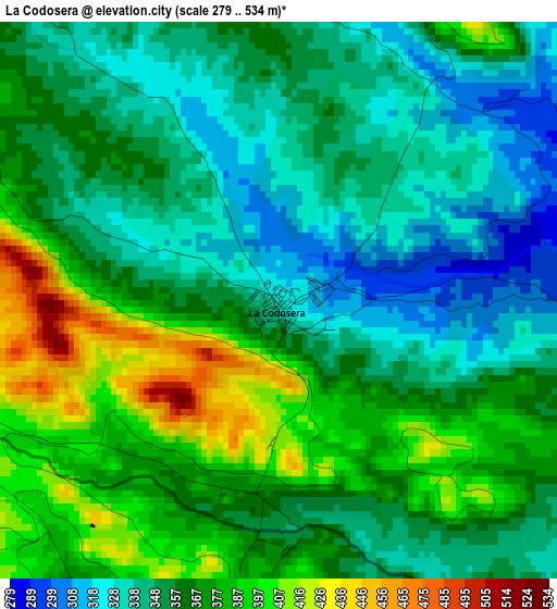
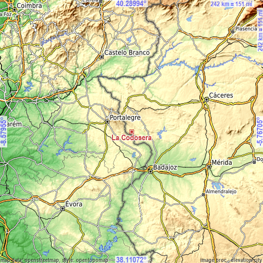
| \ | Map #1 | Topo.Map |
| Scale [m] | 279..534 m | × |
| Scale [ft] | 915..1752 ft | × |
| Average | 361.3 m = 1185 ft | × |
| Width | 7.57 km = 4.7 mi | 242.3 km = 150.6 mi |
| Height | 7.57 km = 4.7 mi | 242.3 km = 150.6 mi |
| ↑Max Latitude | 39.242823° | 40.28994° |
| Latitude at center | 39.20878° | 39.20878° |
| ↓Min Latitude | 39.174721° | 38.11072° |
| ← Min Longitude | -7.217245° | -8.57955° |
| Longitude center | -7.1733° | -7.1733° |
| →Max Longitude | -7.129355° | -5.76705° |
Nearby cities:
Cities around La Codosera sort by population:
• Badajoz elevation 192 m
40.7 km,  154°
154°
• Valencia de Alcántara 465 m
23.4 km,  344°
344°
• Alburquerque 426 m
14.8 km,  84°
84°
• Talavera La Real 188 m
50.7 km,  136°
136°
• Villar del Rey 247 m
29.3 km,  106°
106°
• Puebla de Obando 376 m
47.2 km,  94°
94°
• Aliseda 333 m
47.8 km,  60°
60°
• La Roca de la Sierra 248 m
43.2 km,  104°
104°
• Salorino 323 m
33.4 km,  25°
25°
• Carbajo 339 m
43.9 km,  357°
357°
• Santiago de Alcántara 347 m
44.6 km,  352°
352°
• San Vicente de Alcántara 504 m
17.2 km,  10°
10°
Multilingual:
 En español:
La Codosera elevación 323 m.
 En France:
La Codosera élévation 323 m.
 Auf Deutsch:
La Codosera höhe über dem Meeresspiegel ist 323 m.

Sources and notes:
- [note 1] Map square and city borders are not equal. Map elevation data is calculated only from area inside that square.
- [src 1] Elevation data from geonames database provided with same terms of usage.
- [src 2] The elevation map of La Codosera is generated using elevation data from NASA's 3 arcsec (90m) resolution SRTM data.
- [src 3] Base (background) map © OpenStreetMap contributors tiles are generated by Geofabrik and OpenTopoMap.
Copyright & License:
This La Codosera Elevation Map is licensed under CC BY-SA. You may reuse any part from this page, if you give a proper credit by linking to this URL:
 More info on terms of use page.