Lillo elevation
Lillo (Castille-La Mancha, Province of Toledo), Spain elevation is 687 meters and Lillo elevation in feet is 2254 ft above sea level [src 1]. Lillo is a seat of a third-order administrative division (feature code) with elevation that is 84 meters (276 ft) bigger than average city elevation in Spain.
Below is the Elevation map of Lillo, which displays elevation range with different colors. Scale of the first map is from 677 to 803 m (2221 to 2635 ft) with average elevation of 696.4 meters (=2285 ft) [note 1]
These maps also provides idea of topography and contour of this city, they are displayed at different zoom levels. More info about maps, scale and edge coordinates you can find below images.
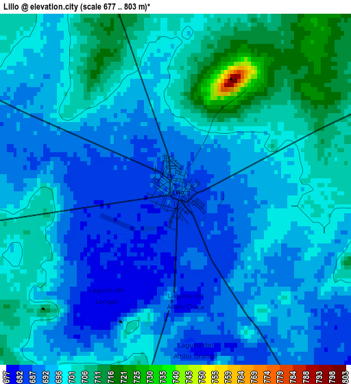
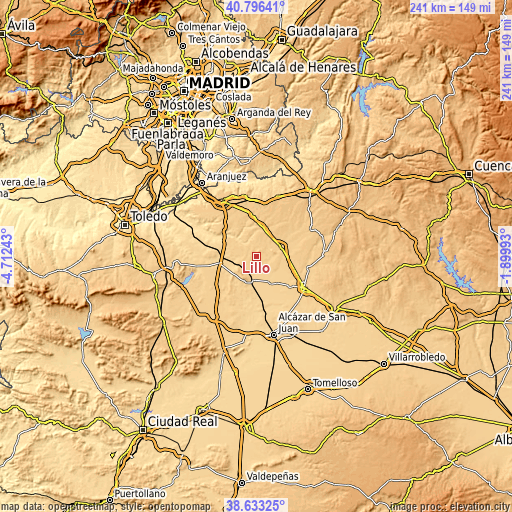
| \ | Map #1 | Topo.Map |
| Scale [m] | 677..803 m | × |
| Scale [ft] | 2221..2635 ft | × |
| Average | 696.4 m = 2285 ft | × |
| Width | 7.52 km = 4.7 mi | 240.5 km = 149.4 mi |
| Height | 7.52 km = 4.7 mi | 240.5 km = 149.4 mi |
| ↑Max Latitude | 39.757102° | 40.79641° |
| Latitude at center | 39.72331° | 39.72331° |
| ↓Min Latitude | 39.689502° | 38.63325° |
| ← Min Longitude | -3.350125° | -4.71243° |
| Longitude center | -3.30618° | -3.30618° |
| →Max Longitude | -3.262235° | -1.89993° |
Nearby cities:
Cities around Lillo sort by population:
• Quintanar de la Orden elevation 692 m
26.8 km,  122°
122°
• Villacañas 677 m
11.4 km,  193°
193°
• Corral de Almaguer 706 m
12.8 km,  71°
71°
• La Puebla de Almoradiel 695 m
21.3 km,  130°
130°
• Villa de Don Fadrique 672 m
14.2 km,  148°
148°
• Villanueva de Alcardete 729 m
25.6 km,  102°
102°
• Villatobas 736 m
19.9 km,  355°
355°
• La Guardia 704 m
16.2 km,  296°
296°
• Dosbarrios 714 m
23.3 km,  319°
319°
• Tembleque 640 m
17.2 km,  259°
259°
• Quero 654 m
24.1 km,  167°
167°
• Cabezamesada 735 m
20.3 km,  59°
59°
Multilingual:
 En español:
Lillo elevación 687 m.
 En France:
Lillo élévation 687 m.


Sources and notes:
- [note 1] Map square and city borders are not equal. Map elevation data is calculated only from area inside that square.
- [src 1] Elevation data from geonames database provided with same terms of usage.
- [src 2] The elevation map of Lillo is generated using elevation data from NASA's 3 arcsec (90m) resolution SRTM data.
- [src 3] Base (background) map © OpenStreetMap contributors tiles are generated by Geofabrik and OpenTopoMap.
Copyright & License:
This Lillo Elevation Map is licensed under CC BY-SA. You may reuse any part from this page, if you give a proper credit by linking to this URL:
 More info on terms of use page.