Tembleque elevation
Tembleque (Castille-La Mancha, Province of Toledo), Spain elevation is 640 meters and Tembleque elevation in feet is 2100 ft above sea level [src 1]. Tembleque is a seat of a third-order administrative division (feature code) with elevation that is 37 meters (121 ft) bigger than average city elevation in Spain.
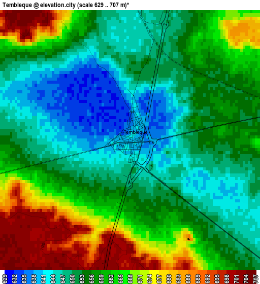
Below is the Elevation map of Tembleque, which displays elevation range with different colors. Scale of the first map is from 629 to 707 m (2064 to 2320 ft) with average elevation of 657.5 meters (=2157 ft) [note 1]
These maps also provides idea of topography and contour of this city, they are displayed at different zoom levels. More info about maps, scale and edge coordinates you can find below images.
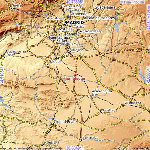
| \ | Map #1 | Topo.Map |
| Scale [m] | 629..707 m | × |
| Scale [ft] | 2064..2320 ft | × |
| Average | 657.5 m = 2157 ft | × |
| Width | 7.52 km = 4.7 mi | 240.6 km = 149.5 mi |
| Height | 7.52 km = 4.7 mi | 240.6 km = 149.5 mi |
| ↑Max Latitude | 39.729215° | 40.76895° |
| Latitude at center | 39.69541° | 39.69541° |
| ↓Min Latitude | 39.661588° | 38.60491° |
| ← Min Longitude | -3.548235° | -4.91054° |
| Longitude center | -3.50429° | -3.50429° |
| →Max Longitude | -3.460345° | -2.09804° |
Nearby cities:
Cities around Tembleque sort by population:
• Madridejos elevation 693 m
25.4 km,  185°
185°
• Villacañas 677 m
16.3 km,  119°
119°
• Mora 722 m
23.1 km,  267°
267°
• Yepes 703 m
25.2 km,  335°
335°
• Lillo 687 m
17.2 km,  79°
79°
• La Guardia 704 m
10.6 km,  13°
13°
• Dosbarrios 714 m
20.8 km,  4°
4°
• Huerta de Valdecarábanos 624 m
20.8 km,  333°
333°
• Turleque 694 m
14.1 km,  221°
221°
• Villanueva de Bogas 657 m
13.5 km,  283°
283°
• Villamuelas 591 m
23.9 km,  304°
304°
• Cabañas de Yepes 710 m
21.9 km,  353°
353°
Multilingual:
 En español:
Tembleque elevación 640 m.
 En France:
Tembleque élévation 640 m.
 Auf Deutsch:
Tembleque höhe über dem Meeresspiegel ist 640 m.

Sources and notes:
- [note 1] Map square and city borders are not equal. Map elevation data is calculated only from area inside that square.
- [src 1] Elevation data from geonames database provided with same terms of usage.
- [src 2] The elevation map of Tembleque is generated using elevation data from NASA's 3 arcsec (90m) resolution SRTM data.
- [src 3] Base (background) map © OpenStreetMap contributors tiles are generated by Geofabrik and OpenTopoMap.
Copyright & License:
This Tembleque Elevation Map is licensed under CC BY-SA. You may reuse any part from this page, if you give a proper credit by linking to this URL:
 More info on terms of use page.