Lucillos elevation
Lucillos (Castille-La Mancha, Province of Toledo), Spain elevation is 481 meters and Lucillos elevation in feet is 1578 ft above sea level [src 1]. Lucillos is a seat of a third-order administrative division (feature code) with elevation that is 122 meters (400 ft) smaller than average city elevation in Spain.
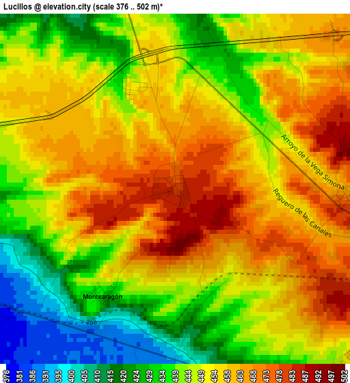
Below is the Elevation map of Lucillos, which displays elevation range with different colors. Scale of the first map is from 376 to 502 m (1234 to 1647 ft) with average elevation of 449.5 meters (=1475 ft) [note 1]
These maps also provides idea of topography and contour of this city, they are displayed at different zoom levels. More info about maps, scale and edge coordinates you can find below images.
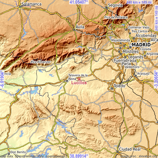
| \ | Map #1 | Topo.Map |
| Scale [m] | 376..502 m | × |
| Scale [ft] | 1234..1647 ft | × |
| Average | 449.5 m = 1475 ft | × |
| Width | 7.49 km = 4.7 mi | 239.6 km = 148.9 mi |
| Height | 7.49 km = 4.7 mi | 239.6 km = 148.9 mi |
| ↑Max Latitude | 40.018763° | 41.05407° |
| Latitude at center | 39.9851° | 39.9851° |
| ↓Min Latitude | 39.95142° | 38.89914° |
| ← Min Longitude | -4.656735° | -6.01904° |
| Longitude center | -4.61279° | -4.61279° |
| →Max Longitude | -4.568845° | -3.20654° |
Nearby cities:
Cities around Lucillos sort by population:
• Cebolla elevation 444 m
5.3 km,  138°
138°
• La Pueblanueva 482 m
9.9 km,  214°
214°
• Malpica 398 m
11.1 km,  151°
151°
• Cazalegas 443 m
6 km,  296°
296°
• El Casar de Escalona 466 m
10.1 km,  47°
47°
• Domingo Pérez 498 m
9.2 km,  95°
95°
• Montearagón 432 m
2.8 km,  215°
215°
• Carriches 551 m
13.3 km, 100°
• Cardiel de los Montes 405 m
9.4 km,  337°
337°
• Otero 465 m
8.5 km,  78°
78°
• Erustes 536 m
10.4 km,  107°
107°
• Illán de Vacas 480 m
5 km, 108°
Multilingual:
 En español:
Luc Villos elevación 481 m.
 En France:
Lucillos élévation 481 m.
 Auf Deutsch:
Lucillos höhe über dem Meeresspiegel ist 481 m.

Sources and notes:
- [note 1] Map square and city borders are not equal. Map elevation data is calculated only from area inside that square.
- [src 1] Elevation data from geonames database provided with same terms of usage.
- [src 2] The elevation map of Lucillos is generated using elevation data from NASA's 3 arcsec (90m) resolution SRTM data.
- [src 3] Base (background) map © OpenStreetMap contributors tiles are generated by Geofabrik and OpenTopoMap.
Copyright & License:
This Lucillos Elevation Map is licensed under CC BY-SA. You may reuse any part from this page, if you give a proper credit by linking to this URL:
 More info on terms of use page.