Carriches elevation
Carriches (Castille-La Mancha, Province of Toledo), Spain elevation is 551 meters and Carriches elevation in feet is 1808 ft above sea level [src 1]. Carriches is a seat of a third-order administrative division (feature code) with elevation that is 52 meters (171 ft) smaller than average city elevation in Spain.
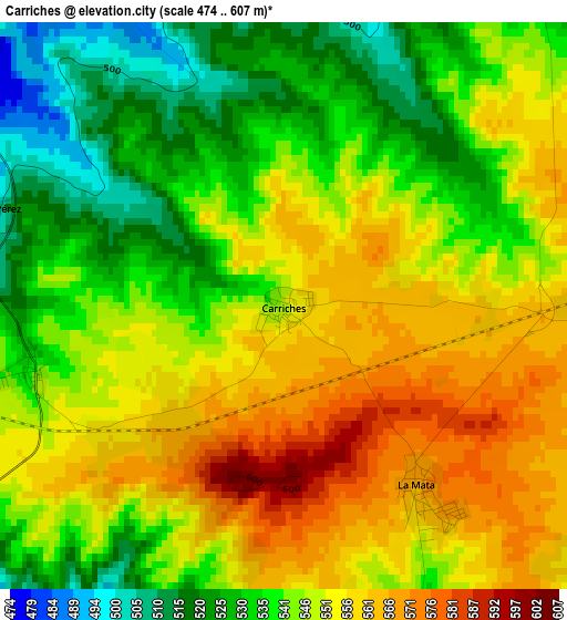
Below is the Elevation map of Carriches, which displays elevation range with different colors. Scale of the first map is from 474 to 607 m (1555 to 1991 ft) with average elevation of 545.5 meters (=1790 ft) [note 1]
These maps also provides idea of topography and contour of this city, they are displayed at different zoom levels. More info about maps, scale and edge coordinates you can find below images.
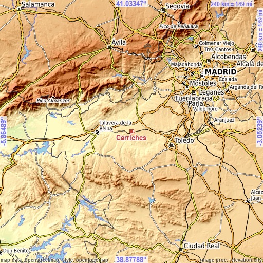
| \ | Map #1 | Topo.Map |
| Scale [m] | 474..607 m | × |
| Scale [ft] | 1555..1991 ft | × |
| Average | 545.5 m = 1790 ft | × |
| Width | 7.49 km = 4.7 mi | 239.7 km = 148.9 mi |
| Height | 7.49 km = 4.7 mi | 239.7 km = 148.9 mi |
| ↑Max Latitude | 39.997843° | 41.03347° |
| Latitude at center | 39.96417° | 39.96417° |
| ↓Min Latitude | 39.93048° | 38.87788° |
| ← Min Longitude | -4.502585° | -5.86489° |
| Longitude center | -4.45864° | -4.45864° |
| →Max Longitude | -4.414695° | -3.05239° |
Nearby cities:
Cities around Carriches sort by population:
• Cebolla elevation 444 m
9.8 km,  260°
260°
• Santa Olalla 486 m
7 km,  20°
20°
• El Carpio de Tajo 486 m
8.5 km,  177°
177°
• Malpica 398 m
10.7 km,  226°
226°
• Escalonilla 545 m
10.1 km,  114°
114°
• El Casar de Escalona 466 m
10.8 km,  328°
328°
• Carmena 559 m
5 km,  101°
101°
• Alcabón 531 m
8.8 km,  61°
61°
• Domingo Pérez 498 m
4.2 km,  289°
289°
• Otero 465 m
6.3 km,  310°
310°
• Erustes 536 m
3.3 km, 255°
• Illán de Vacas 480 m
8.5 km,  274°
274°
Multilingual:
 En español:
Carriches elevación 551 m.
 En France:
Carriches élévation 551 m.
 Auf Deutsch:
Carriches höhe über dem Meeresspiegel ist 551 m.

Sources and notes:
- [note 1] Map square and city borders are not equal. Map elevation data is calculated only from area inside that square.
- [src 1] Elevation data from geonames database provided with same terms of usage.
- [src 2] The elevation map of Carriches is generated using elevation data from NASA's 3 arcsec (90m) resolution SRTM data.
- [src 3] Base (background) map © OpenStreetMap contributors tiles are generated by Geofabrik and OpenTopoMap.
Copyright & License:
This Carriches Elevation Map is licensed under CC BY-SA. You may reuse any part from this page, if you give a proper credit by linking to this URL:
 More info on terms of use page.