Madrigalejo elevation
Madrigalejo (Extremadura, Provincia de Cáceres), Spain elevation is 297 meters and Madrigalejo elevation in feet is 974 ft above sea level [src 1]. Madrigalejo is a seat of a third-order administrative division (feature code) with elevation that is 306 meters (1004 ft) smaller than average city elevation in Spain.
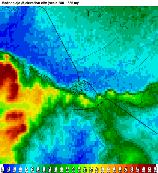
Below is the Elevation map of Madrigalejo, which displays elevation range with different colors. Scale of the first map is from 280 to 356 m (919 to 1168 ft) with average elevation of 300.4 meters (=986 ft) [note 1]
These maps also provides idea of topography and contour of this city, they are displayed at different zoom levels. More info about maps, scale and edge coordinates you can find below images.
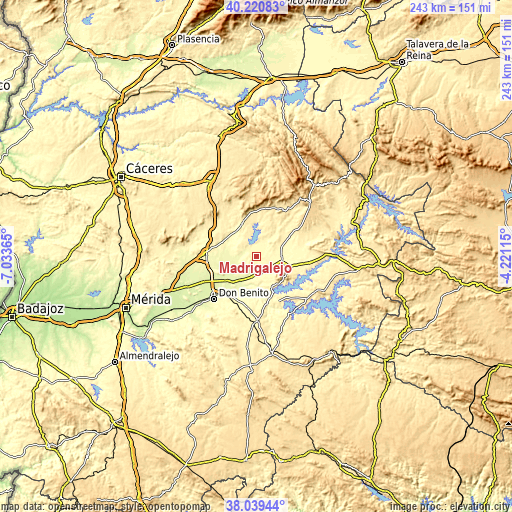
| \ | Map #1 | Topo.Map |
| Scale [m] | 280..356 m | × |
| Scale [ft] | 919..1168 ft | × |
| Average | 300.4 m = 986 ft | × |
| Width | 7.58 km = 4.7 mi | 242.5 km = 150.7 mi |
| Height | 7.58 km = 4.7 mi | 242.5 km = 150.7 mi |
| ↑Max Latitude | 39.172657° | 40.22083° |
| Latitude at center | 39.13858° | 39.13858° |
| ↓Min Latitude | 39.104487° | 38.03944° |
| ← Min Longitude | -5.671345° | -7.03365° |
| Longitude center | -5.6274° | -5.6274° |
| →Max Longitude | -5.583455° | -4.22115° |
Nearby cities:
Cities around Madrigalejo sort by population:
• Villanueva de la Serena elevation 290 m
23.2 km,  219°
219°
• Miajadas 298 m
24.3 km,  273°
273°
• Navalvillar de Pela 336 m
14.6 km,  109°
109°
• Orellana la Vieja 356 m
16.8 km,  151°
151°
• Zorita 428 m
17.5 km,  339°
339°
• Villar de Rena 269 m
17.3 km,  246°
246°
• Escurial 317 m
22.4 km,  278°
278°
• Acedera 297 m
8.3 km, 146°
• Rena 258 m
18.3 km,  238°
238°
• Abertura 400 m
19.9 km,  305°
305°
• Villamesías 369 m
24.3 km,  299°
299°
• Alcollarín 315 m
15.2 km,  320°
320°
Multilingual:
 En español:
Madrigalejo elevación 297 m.
 En France:
Madrigalejo élévation 297 m.
 Auf Deutsch:
Madrigalejo höhe über dem Meeresspiegel ist 297 m.

Sources and notes:
- [note 1] Map square and city borders are not equal. Map elevation data is calculated only from area inside that square.
- [src 1] Elevation data from geonames database provided with same terms of usage.
- [src 2] The elevation map of Madrigalejo is generated using elevation data from NASA's 3 arcsec (90m) resolution SRTM data.
- [src 3] Base (background) map © OpenStreetMap contributors tiles are generated by Geofabrik and OpenTopoMap.
Copyright & License:
This Madrigalejo Elevation Map is licensed under CC BY-SA. You may reuse any part from this page, if you give a proper credit by linking to this URL:
 More info on terms of use page.