Rena elevation
Rena (Extremadura, Provincia de Badajoz), Spain elevation is 258 meters and Rena elevation in feet is 846 ft above sea level [src 1]. Rena is a seat of a third-order administrative division (feature code) with elevation that is 345 meters (1132 ft) smaller than average city elevation in Spain.
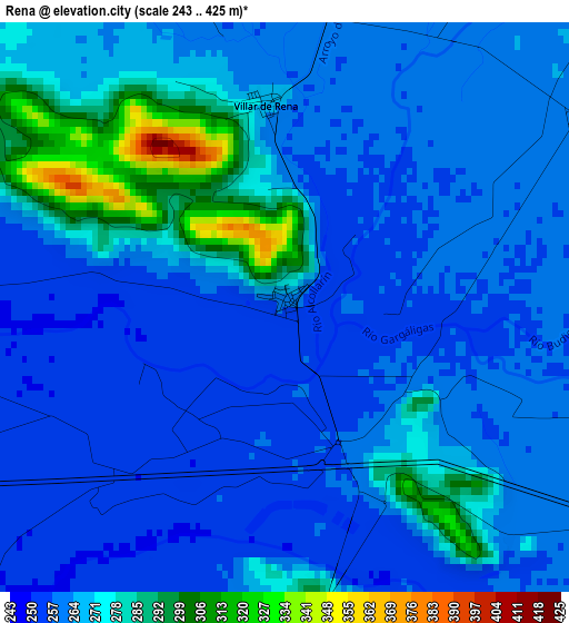
Below is the Elevation map of Rena, which displays elevation range with different colors. Scale of the first map is from 243 to 425 m (797 to 1394 ft) with average elevation of 266.2 meters (=873 ft) [note 1]
These maps also provides idea of topography and contour of this city, they are displayed at different zoom levels. More info about maps, scale and edge coordinates you can find below images.
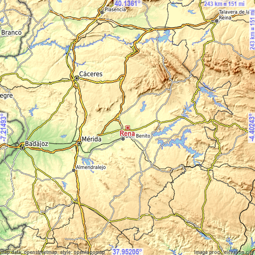
| \ | Map #1 | Topo.Map |
| Scale [m] | 243..425 m | × |
| Scale [ft] | 797..1394 ft | × |
| Average | 266.2 m = 873 ft | × |
| Width | 7.59 km = 4.7 mi | 242.8 km = 150.9 mi |
| Height | 7.59 km = 4.7 mi | 242.8 km = 150.9 mi |
| ↑Max Latitude | 39.086638° | 40.1361° |
| Latitude at center | 39.05252° | 39.05252° |
| ↓Min Latitude | 39.018385° | 37.95205° |
| ← Min Longitude | -5.852625° | -7.21493° |
| Longitude center | -5.80868° | -5.80868° |
| →Max Longitude | -5.764735° | -4.40243° |
Nearby cities:
Cities around Rena sort by population:
• Don Benito elevation 285 m
11.6 km,  203°
203°
• Villanueva de la Serena 290 m
8.5 km,  173°
173°
• Miajadas 298 m
14 km,  321°
321°
• Santa Amalia 252 m
18.1 km,  255°
255°
• Medellín 251 m
16.3 km,  232°
232°
• La Coronada 349 m
19 km,  140°
140°
• Madrigalejo 297 m
18.3 km,  58°
58°
• Villar de Rena 269 m
2.7 km,  356°
356°
• La Haba 313 m
14.8 km,  177°
177°
• Escurial 317 m
14.5 km,  333°
333°
• Magacela 456 m
18.5 km,  159°
159°
• Mengabril 253 m
16.9 km,  219°
219°
Multilingual:
 En español:
Rena elevación 258 m.
 En France:
Rena élévation 258 m.


Sources and notes:
- [note 1] Map square and city borders are not equal. Map elevation data is calculated only from area inside that square.
- [src 1] Elevation data from geonames database provided with same terms of usage.
- [src 2] The elevation map of Rena is generated using elevation data from NASA's 3 arcsec (90m) resolution SRTM data.
- [src 3] Base (background) map © OpenStreetMap contributors tiles are generated by Geofabrik and OpenTopoMap.
Copyright & License:
This Rena Elevation Map is licensed under CC BY-SA. You may reuse any part from this page, if you give a proper credit by linking to this URL:
 More info on terms of use page.