Alcollarín elevation
Alcollarín (Extremadura, Provincia de Cáceres), Spain elevation is 315 meters and Alcollarín elevation in feet is 1033 ft above sea level [src 1]. Alcollarín is a seat of a third-order administrative division (feature code) with elevation that is 288 meters (945 ft) smaller than average city elevation in Spain.
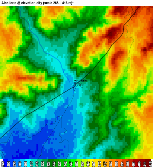
Below is the Elevation map of Alcollarín, which displays elevation range with different colors. Scale of the first map is from 288 to 416 m (945 to 1365 ft) with average elevation of 340.4 meters (=1117 ft) [note 1]
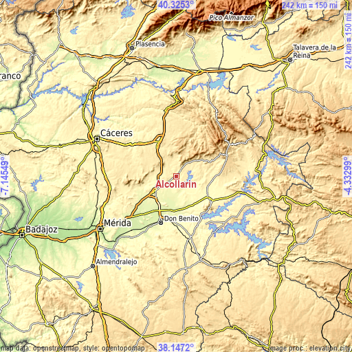
These maps also provides idea of topography and contour of this city, they are displayed at different zoom levels. More info about maps, scale and edge coordinates you can find below images.
| \ | Map #1 | Topo.Map |
| Scale [m] | 288..416 m | × |
| Scale [ft] | 945..1365 ft | × |
| Average | 340.4 m = 1117 ft | × |
| Width | 7.57 km = 4.7 mi | 242.2 km = 150.5 mi |
| Height | 7.57 km = 4.7 mi | 242.2 km = 150.5 mi |
| ↑Max Latitude | 39.278725° | 40.3253° |
| Latitude at center | 39.2447° | 39.2447° |
| ↓Min Latitude | 39.210658° | 38.1472° |
| ← Min Longitude | -5.783185° | -7.14549° |
| Longitude center | -5.73924° | -5.73924° |
| →Max Longitude | -5.695295° | -4.33299° |
Nearby cities:
Cities around Alcollarín sort by population:
• Miajadas elevation 298 m
17.9 km,  234°
234°
• Madrigalejo 297 m
15.2 km,  140°
140°
• Zorita 428 m
5.6 km,  37°
37°
• Villar de Rena 269 m
19.7 km,  198°
198°
• Escurial 317 m
15.1 km,  235°
235°
• Ibahernando 532 m
17.8 km,  300°
300°
• Abertura 400 m
6.4 km,  268°
268°
• Puerto de Santa Cruz 458 m
13 km,  307°
307°
• Herguijuela 463 m
14.5 km,  352°
352°
• Villamesías 369 m
11.5 km, 270°
• Santa Cruz de la Sierra 455 m
13.7 km,  318°
318°
• Conquista de la Sierra 441 m
11.8 km,  1°
1°
Multilingual:
 En español:
Alcollarín elevación 315 m.
 En France:
Alcollarín élévation 315 m.
 Auf Deutsch:
Alcollarín höhe über dem Meeresspiegel ist 315 m.

Sources and notes:
- [note 1] Map square and city borders are not equal. Map elevation data is calculated only from area inside that square.
- [src 1] Elevation data from geonames database provided with same terms of usage.
- [src 2] The elevation map of Alcollarín is generated using elevation data from NASA's 3 arcsec (90m) resolution SRTM data.
- [src 3] Base (background) map © OpenStreetMap contributors tiles are generated by Geofabrik and OpenTopoMap.
Copyright & License:
This Alcollarín Elevation Map is licensed under CC BY-SA. You may reuse any part from this page, if you give a proper credit by linking to this URL:
 More info on terms of use page.