Malagón elevation
Malagón (Castille-La Mancha, Provincia de Ciudad Real), Spain elevation is 638 meters and Malagón elevation in feet is 2093 ft above sea level [src 1]. Malagón is a seat of a third-order administrative division (feature code) with elevation that is 35 meters (115 ft) bigger than average city elevation in Spain.
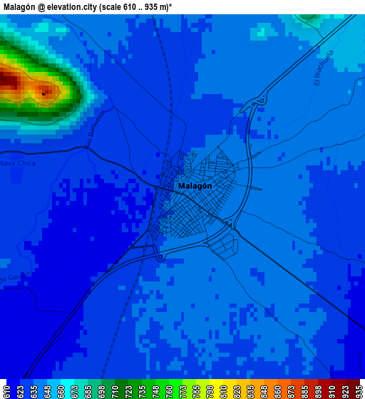
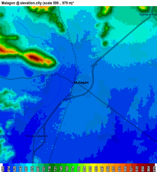
Below is the Elevation map of Malagón, which displays elevation range with different colors. Scale of the first map is from 610 to 935 m (2001 to 3068 ft) with average elevation of 638.5 meters (=2095 ft) [note 1]
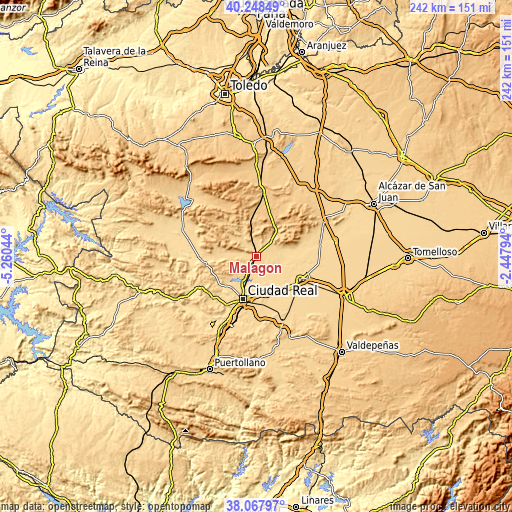
These maps also provides idea of topography and contour of this city, they are displayed at different zoom levels. More info about maps, scale and edge coordinates you can find below images.
| \ | Map #1 | Map #2 | Topo.Map |
| Scale [m] | 610..935 m | 599..979 m | × |
| Scale [ft] | 2001..3068 ft | 1965..3212 ft | × |
| Average | 638.5 m = 2095 ft | 645.3 m = 2117 ft | × |
| Width | 7.58 km = 4.7 mi | 15.15 km = 9.4 mi | 242.5 km = 150.7 mi |
| Height | 7.58 km = 4.7 mi | 15.15 km = 9.4 mi | 242.4 km = 150.6 mi |
| ↑Max Latitude | 39.200743° | 39.23479° | 40.24849° |
| Latitude at center | 39.16668° | 39.16668° | 39.16668° |
| ↓Min Latitude | 39.1326° | 39.098504° | 38.06797° |
| ← Min Longitude | -3.898135° | -3.942081° | -5.26044° |
| Longitude center | -3.85419° | -3.85419° | -3.85419° |
| →Max Longitude | -3.810245° | -3.766299° | -2.44794° |
Nearby cities:
Cities around Malagón sort by population:
• Ciudad Real elevation 633 m
21.1 km,  197°
197°
• Daimiel 624 m
23.3 km,  117°
117°
• Miguelturra 631 m
22.7 km,  187°
187°
• Villarrubia de los Ojos 629 m
22.1 km,  74°
74°
• Porzuna 649 m
26 km,  264°
264°
• Fuente el Fresno 682 m
9.7 km,  44°
44°
• Urda 770 m
29.8 km,  23°
23°
• Torralba de Calatrava 622 m
18.8 km,  151°
151°
• Carrión de Calatrava 618 m
16.7 km,  168°
168°
• Fuencaliente 647 m
14.9 km,  278°
278°
• Poblete 625 m
28 km, 203°
• Picón 602 m
22 km,  234°
234°
Multilingual:
 En español:
Malagón elevación 638 m.
 En France:
Malagón élévation 638 m.


Sources and notes:
- [note 1] Map square and city borders are not equal. Map elevation data is calculated only from area inside that square.
- [src 1] Elevation data from geonames database provided with same terms of usage.
- [src 2] The elevation map of Malagón is generated using elevation data from NASA's 3 arcsec (90m) resolution SRTM data.
- [src 3] Base (background) map © OpenStreetMap contributors tiles are generated by Geofabrik and OpenTopoMap.
Copyright & License:
This Malagón Elevation Map is licensed under CC BY-SA. You may reuse any part from this page, if you give a proper credit by linking to this URL:
 More info on terms of use page.