Urda elevation
Urda (Castille-La Mancha, Province of Toledo), Spain elevation is 770 meters and Urda elevation in feet is 2526 ft above sea level [src 1]. Urda is a seat of a third-order administrative division (feature code) with elevation that is 167 meters (548 ft) bigger than average city elevation in Spain.
Below is the Elevation map of Urda, which displays elevation range with different colors. Scale of the first map is from 733 to 987 m (2405 to 3238 ft) with average elevation of 801.9 meters (=2631 ft) [note 1]
These maps also provides idea of topography and contour of this city, they are displayed at different zoom levels. More info about maps, scale and edge coordinates you can find below images.
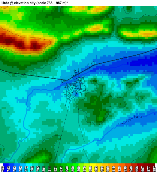
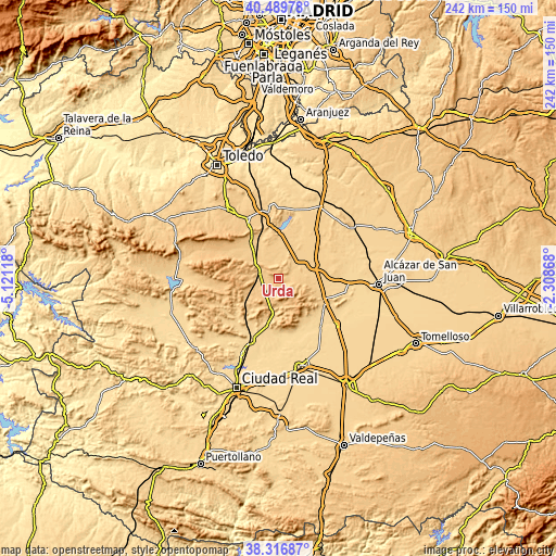
| \ | Map #1 | Topo.Map |
| Scale [m] | 733..987 m | × |
| Scale [ft] | 2405..3238 ft | × |
| Average | 801.9 m = 2631 ft | × |
| Width | 7.55 km = 4.7 mi | 241.6 km = 150.1 mi |
| Height | 7.55 km = 4.7 mi | 241.6 km = 150.1 mi |
| ↑Max Latitude | 39.445734° | 40.48978° |
| Latitude at center | 39.41179° | 39.41179° |
| ↓Min Latitude | 39.377829° | 38.31687° |
| ← Min Longitude | -3.758875° | -5.12118° |
| Longitude center | -3.71493° | -3.71493° |
| →Max Longitude | -3.670985° | -2.30868° |
Nearby cities:
Cities around Urda sort by population:
• Madridejos elevation 693 m
16.9 km,  68°
68°
• Villarrubia de los Ojos 629 m
23.1 km,  156°
156°
• Consuegra 708 m
10.8 km,  58°
58°
• Los Yébenes 823 m
23.1 km,  324°
324°
• Fuente el Fresno 682 m
21 km,  194°
194°
• Orgaz 748 m
29.7 km,  332°
332°
• Camuñas 681 m
22.4 km,  85°
85°
• Arenas de San Juan 629 m
28.2 km,  139°
139°
• Puerto Lápice 678 m
22.3 km,  116°
116°
• Turleque 694 m
22.8 km,  22°
22°
• Manzaneque 719 m
25.7 km,  345°
345°
• Marjaliza 857 m
25.3 km,  311°
311°
Multilingual:
 En español:
Urda elevación 770 m.
 En France:
Urda élévation 770 m.


Sources and notes:
- [note 1] Map square and city borders are not equal. Map elevation data is calculated only from area inside that square.
- [src 1] Elevation data from geonames database provided with same terms of usage.
- [src 2] The elevation map of Urda is generated using elevation data from NASA's 3 arcsec (90m) resolution SRTM data.
- [src 3] Base (background) map © OpenStreetMap contributors tiles are generated by Geofabrik and OpenTopoMap.
Copyright & License:
This Urda Elevation Map is licensed under CC BY-SA. You may reuse any part from this page, if you give a proper credit by linking to this URL:
 More info on terms of use page.