Miguelturra elevation
Miguelturra (Castille-La Mancha, Provincia de Ciudad Real), Spain elevation is 631 meters and Miguelturra elevation in feet is 2070 ft above sea level [src 1]. Miguelturra is a populated place (feature code) with elevation that is 28 meters (92 ft) bigger than average city elevation in Spain.
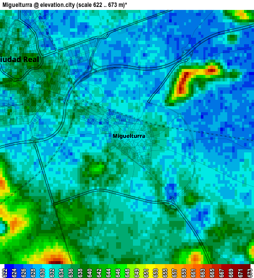
Below is the Elevation map of Miguelturra, which displays elevation range with different colors. Scale of the first map is from 622 to 673 m (2041 to 2208 ft) with average elevation of 632.9 meters (=2076 ft) [note 1]
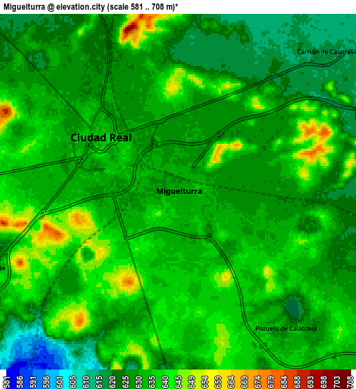
These maps also provides idea of topography and contour of this city, they are displayed at different zoom levels. More info about maps, scale and edge coordinates you can find below images.
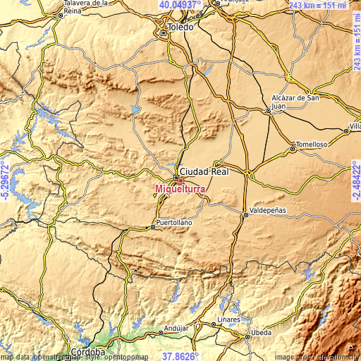
| \ | Map #1 | Map #2 | Topo.Map |
| Scale [m] | 622..673 m | 581..708 m | × |
| Scale [ft] | 2041..2208 ft | 1906..2323 ft | × |
| Average | 632.9 m = 2076 ft | 631.5 m = 2072 ft | × |
| Width | 7.6 km = 4.7 mi | 15.2 km = 9.4 mi | 243.1 km = 151.1 mi |
| Height | 7.6 km = 4.7 mi | 15.2 km = 9.4 mi | 243.1 km = 151.1 mi |
| ↑Max Latitude | 38.998581° | 39.032725° | 40.04937° |
| Latitude at center | 38.96442° | 38.96442° | 38.96442° |
| ↓Min Latitude | 38.930243° | 38.896049° | 37.8626° |
| ← Min Longitude | -3.934415° | -3.978361° | -5.29672° |
| Longitude center | -3.89047° | -3.89047° | -3.89047° |
| →Max Longitude | -3.846525° | -3.802579° | -2.48422° |
Nearby cities:
Cities around Miguelturra sort by population:
• Ciudad Real elevation 633 m
4.1 km,  306°
306°
• Almagro 651 m
17.6 km,  118°
118°
• Torralba de Calatrava 622 m
13.4 km,  63°
63°
• Carrión de Calatrava 618 m
8.8 km,  46°
46°
• Alcolea de Calatrava 653 m
19.7 km,  277°
277°
• Corral de Calatrava 596 m
20.3 km,  234°
234°
• Poblete 625 m
8.5 km,  247°
247°
• Valenzuela de Calatrava 659 m
16.1 km,  140°
140°
• Picón 602 m
17.6 km,  303°
303°
• Villar del Pozo 639 m
14.2 km,  206°
206°
• Cañada de Calatrava 650 m
16.7 km,  222°
222°
• Ballesteros de Calatrava 654 m
15.2 km,  198°
198°
Multilingual:
 En español:
Miguelturra elevación 631 m.
 En France:
Miguelturra élévation 631 m.
 Auf Deutsch:
Miguelturra höhe über dem Meeresspiegel ist 631 m.

Sources and notes:
- [note 1] Map square and city borders are not equal. Map elevation data is calculated only from area inside that square.
- [src 1] Elevation data from geonames database provided with same terms of usage.
- [src 2] The elevation map of Miguelturra is generated using elevation data from NASA's 3 arcsec (90m) resolution SRTM data.
- [src 3] Base (background) map © OpenStreetMap contributors tiles are generated by Geofabrik and OpenTopoMap.
Copyright & License:
This Miguelturra Elevation Map is licensed under CC BY-SA. You may reuse any part from this page, if you give a proper credit by linking to this URL:
 More info on terms of use page.