Siete Aguas elevation
Siete Aguas (Valencia, Província de València), Spain elevation is 689 meters and Siete Aguas elevation in feet is 2260 ft above sea level [src 1]. Siete Aguas is a seat of a third-order administrative division (feature code) with elevation that is 86 meters (282 ft) bigger than average city elevation in Spain.
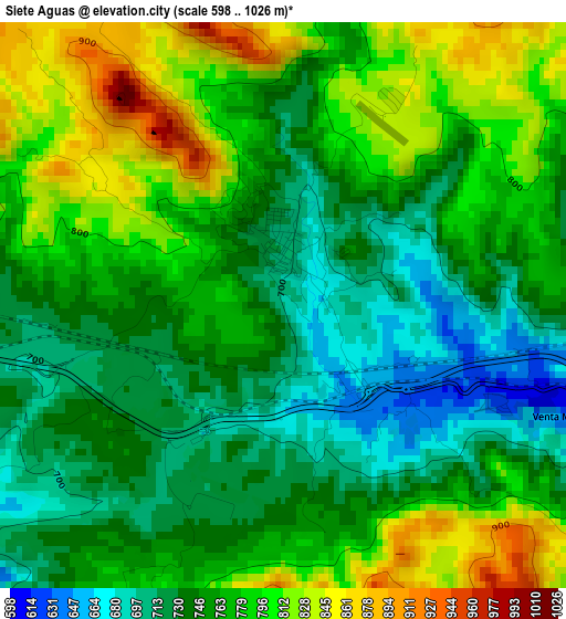
Below is the Elevation map of Siete Aguas, which displays elevation range with different colors. Scale of the first map is from 598 to 1026 m (1962 to 3366 ft) with average elevation of 762.8 meters (=2503 ft) [note 1]
These maps also provides idea of topography and contour of this city, they are displayed at different zoom levels. More info about maps, scale and edge coordinates you can find below images.
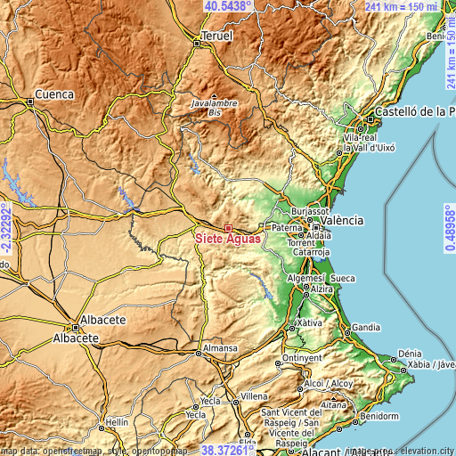
| \ | Map #1 | Topo.Map |
| Scale [m] | 598..1026 m | × |
| Scale [ft] | 1962..3366 ft | × |
| Average | 762.8 m = 2503 ft | × |
| Width | 7.54 km = 4.7 mi | 241.4 km = 150 mi |
| Height | 7.54 km = 4.7 mi | 241.4 km = 150 mi |
| ↑Max Latitude | 39.500587° | 40.5438° |
| Latitude at center | 39.46667° | 39.46667° |
| ↓Min Latitude | 39.432736° | 38.37261° |
| ← Min Longitude | -0.960615° | -2.32292° |
| Longitude center | -0.91667° | -0.91667° |
| →Max Longitude | -0.872725° | 0.48958° |
Nearby cities:
Cities around Siete Aguas sort by population:
• Requena elevation 699 m
16 km,  278°
278°
• Chiva 337 m
17.2 km,  90°
90°
• Buñol 347 m
12.7 km,  115°
115°
• Cheste 209 m
20.1 km,  84°
84°
• Godelleta 292 m
20.8 km,  105°
105°
• Yátova 408 m
13.6 km,  132°
132°
• Macastre 361 m
14.7 km, 128°
• Alborache 296 m
15.9 km, 125°
• Chulilla 339 m
20.6 km,  7°
7°
• Gestalgar 186 m
16.5 km,  25°
25°
• Chera 624 m
15.4 km,  343°
343°
• Sot de Chera 430 m
18.6 km,  4°
4°
Multilingual:
 En español:
Siete Aguas elevación 689 m.
 En France:
Siete Aguas élévation 689 m.
 Auf Deutsch:
Siete Aguas höhe über dem Meeresspiegel ist 689 m.

Sources and notes:
- [note 1] Map square and city borders are not equal. Map elevation data is calculated only from area inside that square.
- [src 1] Elevation data from geonames database provided with same terms of usage.
- [src 2] The elevation map of Siete Aguas is generated using elevation data from NASA's 3 arcsec (90m) resolution SRTM data.
- [src 3] Base (background) map © OpenStreetMap contributors tiles are generated by Geofabrik and OpenTopoMap.
Copyright & License:
This Siete Aguas Elevation Map is licensed under CC BY-SA. You may reuse any part from this page, if you give a proper credit by linking to this URL:
 More info on terms of use page.