Sot de Chera elevation
Sot de Chera (Valencia, Província de València), Spain elevation is 430 meters and Sot de Chera elevation in feet is 1411 ft above sea level [src 1]. Sot de Chera is a seat of a third-order administrative division (feature code) with elevation that is 173 meters (568 ft) smaller than average city elevation in Spain.
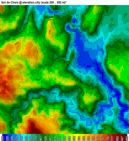
Below is the Elevation map of Sot de Chera, which displays elevation range with different colors. Scale of the first map is from 200 to 852 m (656 to 2795 ft) with average elevation of 442.9 meters (=1453 ft) [note 1]
These maps also provides idea of topography and contour of this city, they are displayed at different zoom levels. More info about maps, scale and edge coordinates you can find below images.
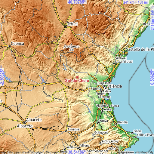
| \ | Map #1 | Topo.Map |
| Scale [m] | 200..852 m | × |
| Scale [ft] | 656..2795 ft | × |
| Average | 442.9 m = 1453 ft | × |
| Width | 7.53 km = 4.7 mi | 240.8 km = 149.6 mi |
| Height | 7.53 km = 4.7 mi | 240.8 km = 149.6 mi |
| ↑Max Latitude | 39.667166° | 40.70785° |
| Latitude at center | 39.63333° | 39.63333° |
| ↓Min Latitude | 39.599478° | 38.54186° |
| ← Min Longitude | -0.943945° | -2.30625° |
| Longitude center | -0.9° | -0.9° |
| →Max Longitude | -0.856055° | 0.50625° |
Nearby cities:
Cities around Sot de Chera sort by population:
• Villar del Arzobispo elevation 486 m
13.2 km,  32°
32°
• Pedralba 149 m
16.1 km,  103°
103°
• Chelva 483 m
15.3 km,  327°
327°
• Siete Aguas 689 m
18.6 km,  184°
184°
• Loriguilla 525 m
5.7 km,  345°
345°
• Bugarra 225 m
11.6 km, 99°
• Chulilla 339 m
2.3 km,  37°
37°
• Gestalgar 186 m
6.8 km,  122°
122°
• Chera 624 m
6.8 km,  237°
237°
• Higueruelas 778 m
17.2 km,  14°
14°
• Losa del Obispo 460 m
7.9 km,  21°
21°
• Calles 378 m
11.5 km, 328°
Multilingual:
 En español:
Sot de Chera elevación 430 m.
 En France:
Sot de Chera élévation 430 m.
 Auf Deutsch:
Sot de Chera höhe über dem Meeresspiegel ist 430 m.

Sources and notes:
- [note 1] Map square and city borders are not equal. Map elevation data is calculated only from area inside that square.
- [src 1] Elevation data from geonames database provided with same terms of usage.
- [src 2] The elevation map of Sot de Chera is generated using elevation data from NASA's 3 arcsec (90m) resolution SRTM data.
- [src 3] Base (background) map © OpenStreetMap contributors tiles are generated by Geofabrik and OpenTopoMap.
Copyright & License:
This Sot de Chera Elevation Map is licensed under CC BY-SA. You may reuse any part from this page, if you give a proper credit by linking to this URL:
 More info on terms of use page.