Chiva elevation
Chiva (Valencia, Província de València), Spain elevation is 337 meters and Chiva elevation in feet is 1106 ft above sea level [src 1]. Chiva is a seat of a third-order administrative division (feature code) with elevation that is 266 meters (873 ft) smaller than average city elevation in Spain.
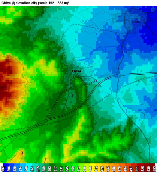
Below is the Elevation map of Chiva, which displays elevation range with different colors. Scale of the first map is from 192 to 553 m (630 to 1814 ft) with average elevation of 304.4 meters (=999 ft) [note 1]
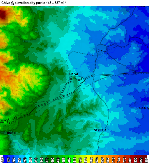
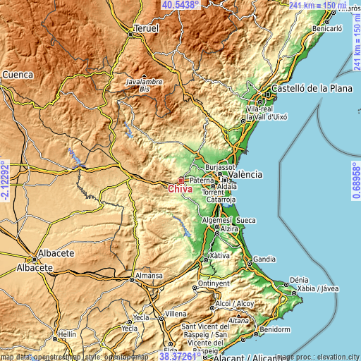
These maps also provides idea of topography and contour of this city, they are displayed at different zoom levels. More info about maps, scale and edge coordinates you can find below images.
| \ | Map #1 | Map #2 | Topo.Map |
| Scale [m] | 192..553 m | 145..887 m | × |
| Scale [ft] | 630..1814 ft | 476..2910 ft | × |
| Average | 304.4 m = 999 ft | 321.5 m = 1055 ft | × |
| Width | 7.54 km = 4.7 mi | 15.09 km = 9.4 mi | 241.4 km = 150 mi |
| Height | 7.54 km = 4.7 mi | 15.09 km = 9.4 mi | 241.4 km = 150 mi |
| ↑Max Latitude | 39.500587° | 39.534488° | 40.5438° |
| Latitude at center | 39.46667° | 39.46667° | 39.46667° |
| ↓Min Latitude | 39.432736° | 39.398786° | 38.37261° |
| ← Min Longitude | -0.760615° | -0.804561° | -2.12292° |
| Longitude center | -0.71667° | -0.71667° | -0.71667° |
| →Max Longitude | -0.672725° | -0.628779° | 0.68958° |
Nearby cities:
Cities around Chiva sort by population:
• Ribarroja del Turia elevation 103 m
15.3 km,  54°
54°
• Buñol 347 m
8 km,  225°
225°
• Cheste 209 m
3.4 km,  57°
57°
• Vilamarxant 114 m
13.9 km,  34°
34°
• Turís 252 m
9.4 km,  171°
171°
• Monserrat 197 m
15 km,  137°
137°
• Godelleta 292 m
6.3 km,  152°
152°
• Pedralba 149 m
14.8 km,  0°
0°
• Yátova 408 m
11.7 km,  217°
217°
• Montroy 135 m
17.1 km, 149°
• Macastre 361 m
10.9 km,  211°
211°
• Alborache 296 m
10.2 km,  204°
204°
Multilingual:
 En español:
Chiva elevación 337 m.
 En France:
Chiva élévation 337 m.


Sources and notes:
- [note 1] Map square and city borders are not equal. Map elevation data is calculated only from area inside that square.
- [src 1] Elevation data from geonames database provided with same terms of usage.
- [src 2] The elevation map of Chiva is generated using elevation data from NASA's 3 arcsec (90m) resolution SRTM data.
- [src 3] Base (background) map © OpenStreetMap contributors tiles are generated by Geofabrik and OpenTopoMap.
Copyright & License:
This Chiva Elevation Map is licensed under CC BY-SA. You may reuse any part from this page, if you give a proper credit by linking to this URL:
 More info on terms of use page.