Turrillas elevation
Turrillas (Andalusia, Almería), Spain elevation is 845 meters and Turrillas elevation in feet is 2772 ft above sea level [src 1]. Turrillas is a seat of a third-order administrative division (feature code) with elevation that is 242 meters (794 ft) bigger than average city elevation in Spain.
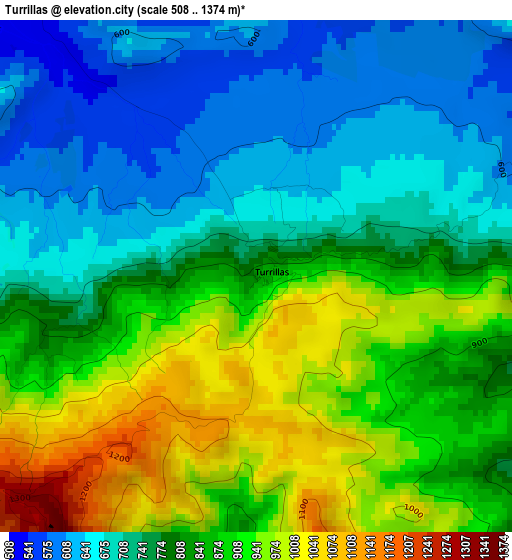
Below is the Elevation map of Turrillas, which displays elevation range with different colors. Scale of the first map is from 508 to 1374 m (1667 to 4508 ft) with average elevation of 805.8 meters (=2644 ft) [note 1]
These maps also provides idea of topography and contour of this city, they are displayed at different zoom levels. More info about maps, scale and edge coordinates you can find below images.
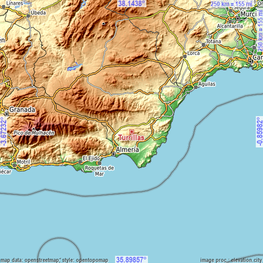
| \ | Map #1 | Topo.Map |
| Scale [m] | 508..1374 m | × |
| Scale [ft] | 1667..4508 ft | × |
| Average | 805.8 m = 2644 ft | × |
| Width | 7.8 km = 4.8 mi | 249.6 km = 155.1 mi |
| Height | 7.8 km = 4.8 mi | 249.6 km = 155.1 mi |
| ↑Max Latitude | 37.064555° | 38.1438° |
| Latitude at center | 37.02948° | 37.02948° |
| ↓Min Latitude | 36.994389° | 35.89857° |
| ← Min Longitude | -2.310015° | -3.67232° |
| Longitude center | -2.26607° | -2.26607° |
| →Max Longitude | -2.222125° | -0.85982° |
Nearby cities:
Cities around Turrillas sort by population:
• Níjar elevation 367 m
8.8 km,  142°
142°
• Viator 75 m
21.1 km,  222°
222°
• Tabernas 404 m
11.3 km,  281°
281°
• Benahadux 128 m
20.7 km,  235°
235°
• Gádor 169 m
21.8 km,  247°
247°
• Sorbas 399 m
14.7 km,  59°
59°
• Rioja 133 m
19.9 km, 241°
• Uleila del Campo 618 m
18.1 km,  17°
17°
• Lucainena de las Torres 560 m
5.9 km,  78°
78°
• Benizalón 941 m
20.4 km,  6°
6°
• Velefique 916 m
21.9 km,  326°
326°
• Pechina 108 m
19.7 km,  230°
230°
Multilingual:
 En español:
Turrillas elevación 845 m.
 En France:
Turrillas élévation 845 m.
 Auf Deutsch:
Turrillas höhe über dem Meeresspiegel ist 845 m.

Sources and notes:
- [note 1] Map square and city borders are not equal. Map elevation data is calculated only from area inside that square.
- [src 1] Elevation data from geonames database provided with same terms of usage.
- [src 2] The elevation map of Turrillas is generated using elevation data from NASA's 3 arcsec (90m) resolution SRTM data.
- [src 3] Base (background) map © OpenStreetMap contributors tiles are generated by Geofabrik and OpenTopoMap.
Copyright & License:
This Turrillas Elevation Map is licensed under CC BY-SA. You may reuse any part from this page, if you give a proper credit by linking to this URL:
 More info on terms of use page.