Velefique elevation
Velefique (Andalusia, Almería), Spain elevation is 916 meters and Velefique elevation in feet is 3005 ft above sea level [src 1]. Velefique is a seat of a third-order administrative division (feature code) with elevation that is 313 meters (1027 ft) bigger than average city elevation in Spain.
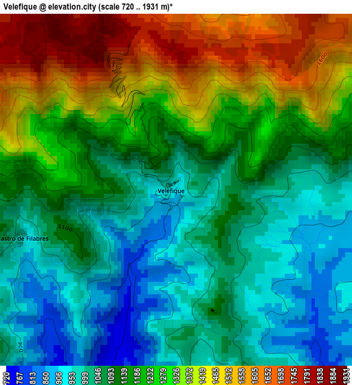
Below is the Elevation map of Velefique, which displays elevation range with different colors. Scale of the first map is from 720 to 1931 m (2362 to 6335 ft) with average elevation of 1179.6 meters (=3870 ft) [note 1]
These maps also provides idea of topography and contour of this city, they are displayed at different zoom levels. More info about maps, scale and edge coordinates you can find below images.
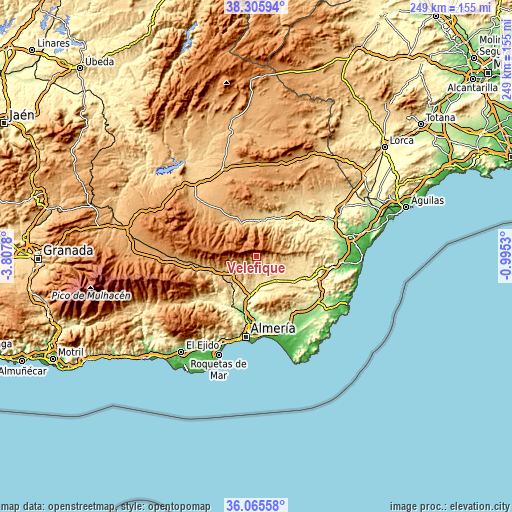
| \ | Map #1 | Topo.Map |
| Scale [m] | 720..1931 m | × |
| Scale [ft] | 2362..6335 ft | × |
| Average | 1179.6 m = 3870 ft | × |
| Width | 7.78 km = 4.8 mi | 249.1 km = 154.8 mi |
| Height | 7.78 km = 4.8 mi | 249.1 km = 154.8 mi |
| ↑Max Latitude | 37.229068° | 38.30594° |
| Latitude at center | 37.19407° | 37.19407° |
| ↓Min Latitude | 37.159055° | 36.06558° |
| ← Min Longitude | -2.445495° | -3.8078° |
| Longitude center | -2.40155° | -2.40155° |
| →Max Longitude | -2.357605° | -0.9953° |
Nearby cities:
Cities around Velefique sort by population:
• La Mojonera elevation 1106 m
11.4 km,  343°
343°
• Gérgal 753 m
14.9 km,  235°
235°
• Sierro 726 m
14.3 km,  1°
1°
• Tahal 1010 m
11 km,  69°
69°
• Benizalón 941 m
14.3 km,  81°
81°
• Chercos 915 m
13.7 km,  60°
60°
• Bayarque 817 m
15.5 km,  348°
348°
• Alcudia de Monteagud 1028 m
12.8 km, 69°
• Castro de Filabres 954 m
3.6 km,  253°
253°
• Olula de Castro 1005 m
6.8 km, 251°
• Laroya 1009 m
13 km,  27°
27°
• Benitagla 952 m
15 km, 73°
Multilingual:
 En español:
Velefique elevación 916 m.
 En France:
Velefique élévation 916 m.
 Auf Deutsch:
Velefique höhe über dem Meeresspiegel ist 916 m.

Sources and notes:
- [note 1] Map square and city borders are not equal. Map elevation data is calculated only from area inside that square.
- [src 1] Elevation data from geonames database provided with same terms of usage.
- [src 2] The elevation map of Velefique is generated using elevation data from NASA's 3 arcsec (90m) resolution SRTM data.
- [src 3] Base (background) map © OpenStreetMap contributors tiles are generated by Geofabrik and OpenTopoMap.
Copyright & License:
This Velefique Elevation Map is licensed under CC BY-SA. You may reuse any part from this page, if you give a proper credit by linking to this URL:
 More info on terms of use page.