Níjar elevation
Níjar (Andalusia, Almería), Spain elevation is 367 meters and Níjar elevation in feet is 1204 ft above sea level [src 1]. Níjar is a seat of a third-order administrative division (feature code) with elevation that is 236 meters (774 ft) smaller than average city elevation in Spain.
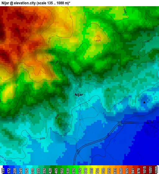
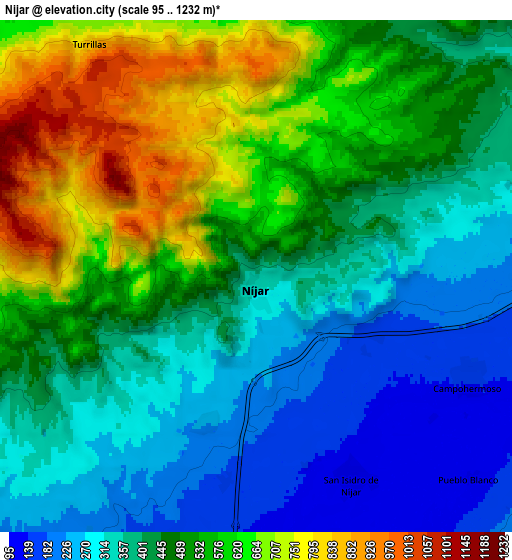
Below is the Elevation map of Níjar, which displays elevation range with different colors. Scale of the first map is from 135 to 1088 m (443 to 3570 ft) with average elevation of 462.5 meters (=1517 ft) [note 1]
These maps also provides idea of topography and contour of this city, they are displayed at different zoom levels. More info about maps, scale and edge coordinates you can find below images.
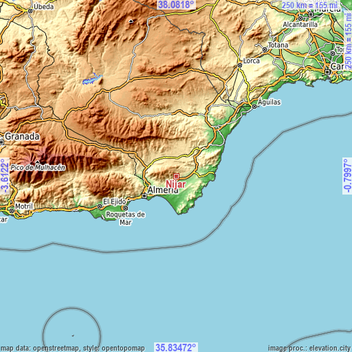
| \ | Map #1 | Map #2 | Topo.Map |
| Scale [m] | 135..1088 m | 95..1232 m | × |
| Scale [ft] | 443..3570 ft | 312..4042 ft | × |
| Average | 462.5 m = 1517 ft | 463.8 m = 1522 ft | × |
| Width | 7.81 km = 4.9 mi | 15.62 km = 9.7 mi | 249.9 km = 155.3 mi |
| Height | 7.81 km = 4.9 mi | 15.62 km = 9.7 mi | 249.9 km = 155.3 mi |
| ↑Max Latitude | 37.001654° | 37.036741° | 38.0818° |
| Latitude at center | 36.96655° | 36.96655° | 36.96655° |
| ↓Min Latitude | 36.93143° | 36.896294° | 35.83472° |
| ← Min Longitude | -2.249895° | -2.293841° | -3.6122° |
| Longitude center | -2.20595° | -2.20595° | -2.20595° |
| →Max Longitude | -2.162005° | -2.118059° | -0.7997° |
Nearby cities:
Cities around Níjar sort by population:
• Huércal de Almería elevation 73 m
22.5 km,  246°
246°
• Retamar 3 m
17.8 km,  213°
213°
• Viator 75 m
21.4 km, 246°
• Tabernas 404 m
18.9 km,  299°
299°
• Benahadux 128 m
23 km,  258°
258°
• Sorbas 399 m
16.3 km,  26°
26°
• Rioja 133 m
23 km, 264°
• Costacabana 6 m
21.1 km,  227°
227°
• Uleila del Campo 618 m
24.2 km,  0°
0°
• Lucainena de las Torres 560 m
8.2 km, 3°
• Turrillas 845 m
8.8 km,  322°
322°
• Pechina 108 m
21.3 km, 254°
Multilingual:
 En español:
Níjar elevación 367 m.
 En France:
Níjar élévation 367 m.


Sources and notes:
- [note 1] Map square and city borders are not equal. Map elevation data is calculated only from area inside that square.
- [src 1] Elevation data from geonames database provided with same terms of usage.
- [src 2] The elevation map of Níjar is generated using elevation data from NASA's 3 arcsec (90m) resolution SRTM data.
- [src 3] Base (background) map © OpenStreetMap contributors tiles are generated by Geofabrik and OpenTopoMap.
Copyright & License:
This Níjar Elevation Map is licensed under CC BY-SA. You may reuse any part from this page, if you give a proper credit by linking to this URL:
 More info on terms of use page.