Vila-real elevation
Vila-real (Valencia, Província de Castelló), Spain elevation is 48 meters and Vila-real elevation in feet is 157 ft above sea level [src 1]. Vila-real is a populated place (feature code) with elevation that is 555 meters (1821 ft) smaller than average city elevation in Spain.
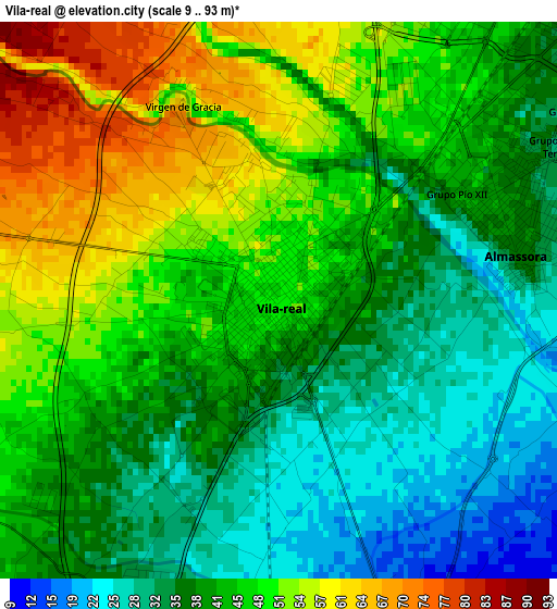
Below is the Elevation map of Vila-real, which displays elevation range with different colors. Scale of the first map is from 9 to 93 m (30 to 305 ft) with average elevation of 42.8 meters (=140 ft) [note 1]
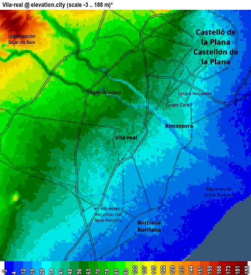
These maps also provides idea of topography and contour of this city, they are displayed at different zoom levels. More info about maps, scale and edge coordinates you can find below images.
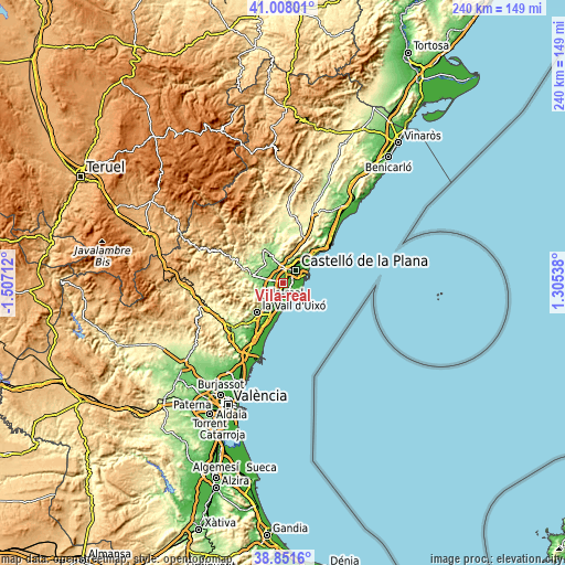
| \ | Map #1 | Map #2 | Topo.Map |
| Scale [m] | 9..93 m | -3..188 m | × |
| Scale [ft] | 30..305 ft | -10..617 ft | × |
| Average | 42.8 m = 140 ft | 47.3 m = 155 ft | × |
| Width | 7.49 km = 4.7 mi | 14.99 km = 9.3 mi | 239.8 km = 149 mi |
| Height | 7.49 km = 4.7 mi | 14.99 km = 9.3 mi | 239.8 km = 149 mi |
| ↑Max Latitude | 39.971986° | 40.005656° | 41.00801° |
| Latitude at center | 39.9383° | 39.9383° | 39.9383° |
| ↓Min Latitude | 39.904597° | 39.870878° | 38.8516° |
| ← Min Longitude | -0.144815° | -0.188761° | -1.50712° |
| Longitude center | -0.10087° | -0.10087° | -0.10087° |
| →Max Longitude | -0.056925° | -0.012979° | 1.30538° |
Nearby cities:
Cities around Vila-real sort by population:
• Castelló de la Plana elevation 37 m
6.9 km,  39°
39°
• Burriana 22 m
5.6 km,  166°
166°
• Onda 192 m
13.9 km,  282°
282°
• Almassora 37 m
3.4 km,  72°
72°
• El Grao 6 m
10.5 km, 67°
• Nules 21 m
10.5 km,  206°
206°
• Betxí 96 m
8.5 km,  266°
266°
• Borriol 199 m
11.9 km,  12°
12°
• Alquerías del Niño Perdido 30 m
5.4 km, 206°
• Villavieja 33 m
12.1 km,  215°
215°
• San Juan de Moró 192 m
13.9 km,  347°
347°
• Artana 259 m
14.4 km,  248°
248°
Multilingual:
 En español:
Villarreal elevación 48 m.
 En France:
Vila-real élévation 48 m.
 Auf Deutsch:
Vila-real höhe über dem Meeresspiegel ist 48 m.

Sources and notes:
- [note 1] Map square and city borders are not equal. Map elevation data is calculated only from area inside that square.
- [src 1] Elevation data from geonames database provided with same terms of usage.
- [src 2] The elevation map of Vila-real is generated using elevation data from NASA's 3 arcsec (90m) resolution SRTM data.
- [src 3] Base (background) map © OpenStreetMap contributors tiles are generated by Geofabrik and OpenTopoMap.
Copyright & License:
This Vila-real Elevation Map is licensed under CC BY-SA. You may reuse any part from this page, if you give a proper credit by linking to this URL:
 More info on terms of use page.