Onda elevation
Onda (Valencia, Província de Castelló), Spain elevation is 192 meters and Onda elevation in feet is 630 ft above sea level [src 1]. Onda is a seat of a third-order administrative division (feature code) with elevation that is 411 meters (1348 ft) smaller than average city elevation in Spain.
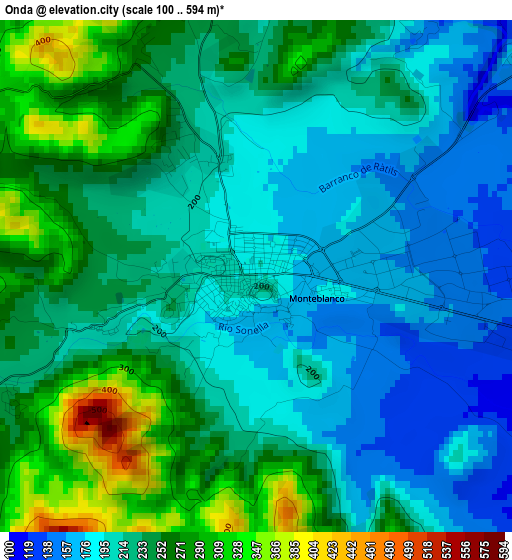
Below is the Elevation map of Onda, which displays elevation range with different colors. Scale of the first map is from 100 to 594 m (328 to 1949 ft) with average elevation of 226.1 meters (=742 ft) [note 1]
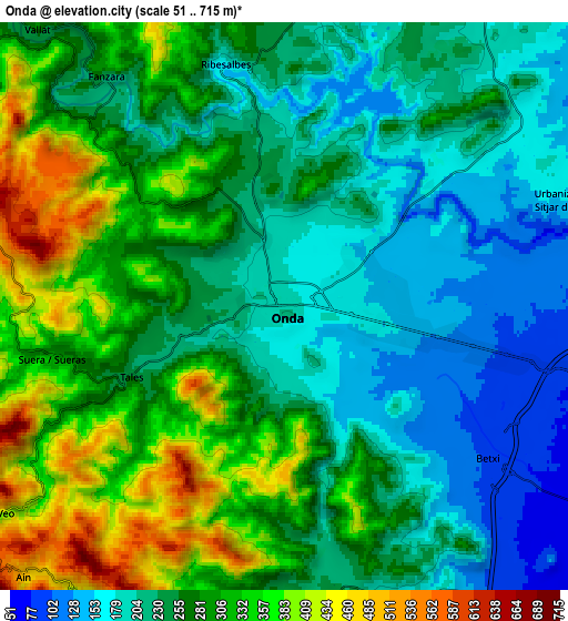
These maps also provides idea of topography and contour of this city, they are displayed at different zoom levels. More info about maps, scale and edge coordinates you can find below images.
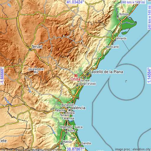
| \ | Map #1 | Map #2 | Topo.Map |
| Scale [m] | 100..594 m | 51..715 m | × |
| Scale [ft] | 328..1949 ft | 167..2346 ft | × |
| Average | 226.1 m = 742 ft | 265.9 m = 872 ft | × |
| Width | 7.49 km = 4.7 mi | 14.98 km = 9.3 mi | 239.7 km = 148.9 mi |
| Height | 7.49 km = 4.7 mi | 14.98 km = 9.3 mi | 239.7 km = 148.9 mi |
| ↑Max Latitude | 39.998623° | 40.032279° | 41.03424° |
| Latitude at center | 39.96495° | 39.96495° | 39.96495° |
| ↓Min Latitude | 39.93126° | 39.897554° | 38.87867° |
| ← Min Longitude | -0.304355° | -0.348301° | -1.66666° |
| Longitude center | -0.26041° | -0.26041° | -0.26041° |
| →Max Longitude | -0.216465° | -0.172519° | 1.14584° |
Nearby cities:
Cities around Onda sort by population:
• l'Alcora elevation 236 m
12.4 km,  24°
24°
• Betxí 96 m
6.2 km,  124°
124°
• Artana 259 m
8.2 km,  178°
178°
• Ribesalbes 199 m
5.8 km,  354°
354°
• Eslida 338 m
9.7 km,  200°
200°
• Tales 248 m
4.4 km,  245°
245°
• Fanzara 217 m
7.5 km,  320°
320°
• Ayódar 443 m
9.9 km,  293°
293°
• Alcudia de Veo 490 m
9.3 km,  234°
234°
• Argelita 291 m
12.2 km, 321°
• Villamalur 554 m
11.9 km,  270°
270°
• Espadilla 250 m
10.8 km,  314°
314°
Multilingual:
 En español:
Onda elevación 192 m.
 En France:
Onda élévation 192 m.


Sources and notes:
- [note 1] Map square and city borders are not equal. Map elevation data is calculated only from area inside that square.
- [src 1] Elevation data from geonames database provided with same terms of usage.
- [src 2] The elevation map of Onda is generated using elevation data from NASA's 3 arcsec (90m) resolution SRTM data.
- [src 3] Base (background) map © OpenStreetMap contributors tiles are generated by Geofabrik and OpenTopoMap.
Copyright & License:
This Onda Elevation Map is licensed under CC BY-SA. You may reuse any part from this page, if you give a proper credit by linking to this URL:
 More info on terms of use page.