Tena elevation
Tena (Napo, Cantón Tena), Ecuador elevation is 504 meters and Tena elevation in feet is 1654 ft above sea level [src 1]. Tena is a seat of a first-order administrative division (feature code) with elevation that is 441 meters (1447 ft) smaller than average city elevation in Ecuador.
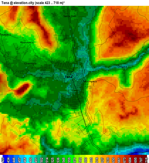
Below is the Elevation map of Tena, which displays elevation range with different colors. Scale of the first map is from 423 to 718 m (1388 to 2356 ft) with average elevation of 576.3 meters (=1891 ft) [note 1]
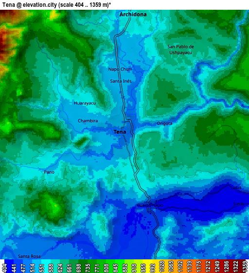
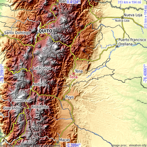
These maps also provides idea of topography and contour of this city, they are displayed at different zoom levels. More info about maps, scale and edge coordinates you can find below images.
| \ | Map #1 | Map #2 | Topo.Map |
| Scale [m] | 423..718 m | 404..1359 m | × |
| Scale [ft] | 1388..2356 ft | 1325..4459 ft | × |
| Average | 576.3 m = 1891 ft | 603.4 m = 1980 ft | × |
| Width | 9.77 km = 6.1 mi | 19.54 km = 12.1 mi | 312.6 km = 194.2 mi |
| Height | 9.77 km = 6.1 mi | 19.54 km = 12.1 mi | 312.7 km = 194.3 mi |
| ↑Max Latitude | -0.949861° | -0.905921° | 0.4124° |
| Latitude at center | -0.9938° | -0.9938° | -0.9938° |
| ↓Min Latitude | -1.037738° | -1.081676° | -2.3994° |
| ← Min Longitude | -77.856805° | -77.900751° | -79.21911° |
| Longitude center | -77.81286° | -77.81286° | -77.81286° |
| →Max Longitude | -77.768915° | -77.724969° | -76.40661° |
Nearby cities:
Cities around Tena sort by population:
• Ambato elevation 2597 m
93.8 km,  252°
252°
• Latacunga 2769 m
89.5 km,  274°
274°
• Puyo 925 m
58.4 km,  201°
201°
• Boca Suno 280 m
81.6 km,  66°
66°
• Pelileo 2589 m
89.4 km, 245°
• San Miguel de Salcedo 2650 m
86.7 km, 266°
• Baños 1805 m
81.3 km,  236°
236°
• Píllaro 2787 m
84 km,  256°
256°
• Archidona 576 m
9.4 km,  3°
3°
• Palora 880 m
80.5 km,  192°
192°
• Saquisilí 2919 m
96.5 km,  280°
280°
• Santa Clara 590 m
31.2 km, 195°
Multilingual:
 En español:
Tena elevación 504 m.
 En France:
Tena élévation 504 m.


Sources and notes:
- [note 1] Map square and city borders are not equal. Map elevation data is calculated only from area inside that square.
- [src 1] Elevation data from geonames database provided with same terms of usage.
- [src 2] The elevation map of Tena is generated using elevation data from NASA's 3 arcsec (90m) resolution SRTM data.
- [src 3] Base (background) map © OpenStreetMap contributors tiles are generated by Geofabrik and OpenTopoMap.
Copyright & License:
This Tena Elevation Map is licensed under CC BY-SA. You may reuse any part from this page, if you give a proper credit by linking to this URL:
 More info on terms of use page.