Béchar elevation
Béchar, Algeria elevation is 780 meters and Béchar elevation in feet is 2559 ft above sea level [src 1]. Béchar is a seat of a first-order administrative division (feature code) with elevation that is 342 meters (1122 ft) bigger than average city elevation in Algeria.
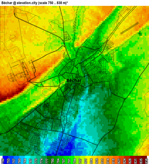
Below is the Elevation map of Béchar, which displays elevation range with different colors. Scale of the first map is from 750 to 838 m (2461 to 2749 ft) with average elevation of 790.5 meters (=2594 ft) [note 1]
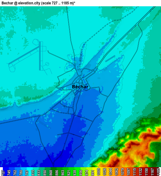
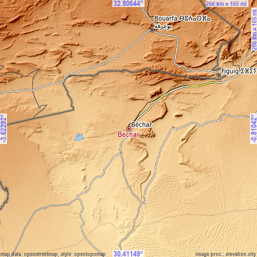
These maps also provides idea of topography and contour of this city, they are displayed at different zoom levels. More info about maps, scale and edge coordinates you can find below images.
| \ | Map #1 | Map #2 | Topo.Map |
| Scale [m] | 750..838 m | 727..1185 m | × |
| Scale [ft] | 2461..2749 ft | 2385..3888 ft | × |
| Average | 790.5 m = 2594 ft | 814.2 m = 2671 ft | × |
| Width | 8.32 km = 5.2 mi | 16.64 km = 10.3 mi | 266.3 km = 165.5 mi |
| Height | 8.32 km = 5.2 mi | 16.64 km = 10.3 mi | 266.3 km = 165.5 mi |
| ↑Max Latitude | 31.654085° | 31.691485° | 32.80644° |
| Latitude at center | 31.61667° | 31.61667° | 31.61667° |
| ↓Min Latitude | 31.57924° | 31.541795° | 30.41149° |
| ← Min Longitude | -2.260615° | -2.304561° | -3.62292° |
| Longitude center | -2.21667° | -2.21667° | -2.21667° |
| →Max Longitude | -2.172725° | -2.128779° | -0.81042° |
Nearby cities:
Cities around Béchar sort by population:
• Tlemcen elevation 811 m
372.2 km,  13°
13°
• Aïn Sefra 1078 m
198.8 km,  50°
50°
• Mansoûra 894 m
369.9 km, 12°
• Timimoun 279 m
351.4 km,  138°
138°
• Hennaya 430 m
379.1 km, 12°
• Sebdou 920 m
345.8 km, 13°
• Chetouane 578 m
377.3 km, 13°
• El Abiodh Sidi Cheikh 903 m
296.2 km,  61°
61°
• Nedroma 355 m
380.2 km, 6°
• Beni Mester 683 m
369.2 km, 11°
• Brezina 855 m
365.8 km, 63°
• Naama 1169 m
255.8 km,  44°
44°
Multilingual:
 En español:
Béchar elevación 780 m.
 En France:
Béchar élévation 780 m.


Sources and notes:
- [note 1] Map square and city borders are not equal. Map elevation data is calculated only from area inside that square.
- [src 1] Elevation data from geonames database provided with same terms of usage.
- [src 2] The elevation map of Béchar is generated using elevation data from NASA's 3 arcsec (90m) resolution SRTM data.
- [src 3] Base (background) map © OpenStreetMap contributors tiles are generated by Geofabrik and OpenTopoMap.
Copyright & License:
This Béchar Elevation Map is licensed under CC BY-SA. You may reuse any part from this page, if you give a proper credit by linking to this URL:
 More info on terms of use page.