Hennaya elevation
Hennaya (Tlemcen), Algeria elevation is 430 meters and Hennaya elevation in feet is 1411 ft above sea level [src 1]. Hennaya is a populated place (feature code) with elevation that is 8 meters (26 ft) smaller than average city elevation in Algeria.
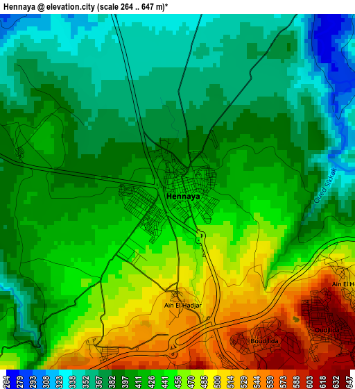
Below is the Elevation map of Hennaya, which displays elevation range with different colors. Scale of the first map is from 264 to 647 m (866 to 2123 ft) with average elevation of 422.2 meters (=1385 ft) [note 1]
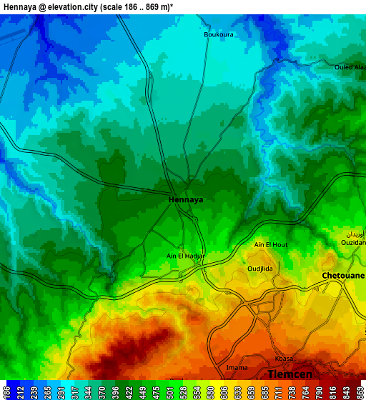
These maps also provides idea of topography and contour of this city, they are displayed at different zoom levels. More info about maps, scale and edge coordinates you can find below images.
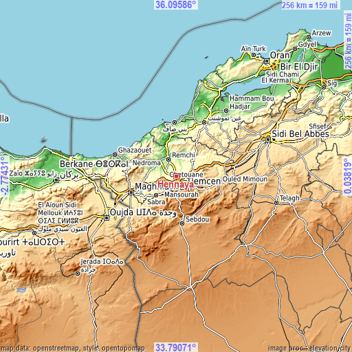
| \ | Map #1 | Map #2 | Topo.Map |
| Scale [m] | 264..647 m | 186..869 m | × |
| Scale [ft] | 866..2123 ft | 610..2851 ft | × |
| Average | 422.2 m = 1385 ft | 440.3 m = 1445 ft | × |
| Width | 8.01 km = 5 mi | 16.02 km = 10 mi | 256.3 km = 159.3 mi |
| Height | 8.01 km = 5 mi | 16.02 km = 10 mi | 256.3 km = 159.3 mi |
| ↑Max Latitude | 34.987401° | 35.023397° | 36.09586° |
| Latitude at center | 34.95139° | 34.95139° | 34.95139° |
| ↓Min Latitude | 34.915363° | 34.87932° | 33.79071° |
| ← Min Longitude | -1.412005° | -1.455951° | -2.77431° |
| Longitude center | -1.36806° | -1.36806° | -1.36806° |
| →Max Longitude | -1.324115° | -1.280169° | 0.03819° |
Nearby cities:
Cities around Hennaya sort by population:
• Tlemcen elevation 811 m
9.5 km,  149°
149°
• Mansoûra 894 m
10.3 km,  165°
165°
• Remchi 209 m
13.7 km,  334°
334°
• Beni Saf 35 m
38.9 km,  358°
358°
• Sebdou 920 m
35.1 km, 174°
• Chetouane 578 m
7.4 km,  116°
116°
• Nedroma 355 m
35.3 km,  281°
281°
• Ouled Mimoun 700 m
30.9 km,  99°
99°
• Sidi Abdelli 465 m
24.8 km,  58°
58°
• Bensekrane 244 m
19 km,  43°
43°
• Beni Mester 683 m
10.3 km,  209°
209°
• Sidi Senoussi سيدي سنوسي 589 m
25.4 km,  78°
78°
Multilingual:
 En español:
Hennaya elevación 430 m.
 En France:
Hennaya élévation 430 m.


Sources and notes:
- [note 1] Map square and city borders are not equal. Map elevation data is calculated only from area inside that square.
- [src 1] Elevation data from geonames database provided with same terms of usage.
- [src 2] The elevation map of Hennaya is generated using elevation data from NASA's 3 arcsec (90m) resolution SRTM data.
- [src 3] Base (background) map © OpenStreetMap contributors tiles are generated by Geofabrik and OpenTopoMap.
Copyright & License:
This Hennaya Elevation Map is licensed under CC BY-SA. You may reuse any part from this page, if you give a proper credit by linking to this URL:
 More info on terms of use page.