Timimoun elevation
Timimoun (Adrar), Algeria elevation is 279 meters and Timimoun elevation in feet is 915 ft above sea level [src 1]. Timimoun is a populated place (feature code) with elevation that is 159 meters (522 ft) smaller than average city elevation in Algeria.
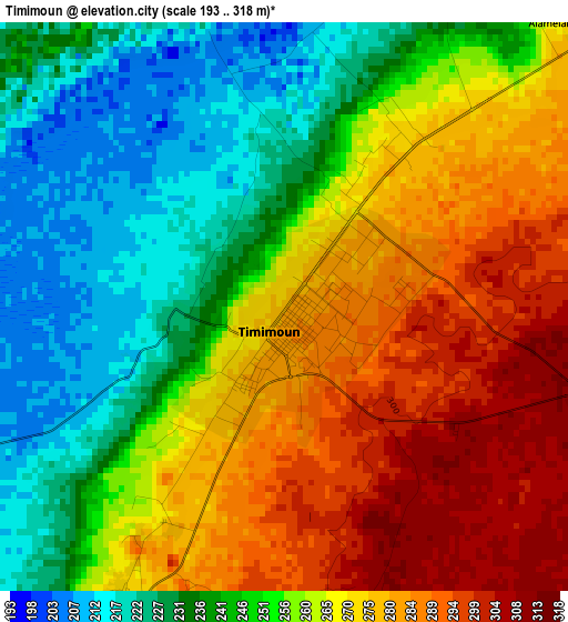
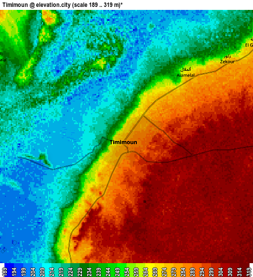
Below is the Elevation map of Timimoun, which displays elevation range with different colors. Scale of the first map is from 193 to 318 m (633 to 1043 ft) with average elevation of 258 meters (=846 ft) [note 1]
These maps also provides idea of topography and contour of this city, they are displayed at different zoom levels. More info about maps, scale and edge coordinates you can find below images.
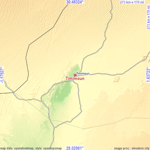
| \ | Map #1 | Map #2 | Topo.Map |
| Scale [m] | 193..318 m | 189..319 m | × |
| Scale [ft] | 633..1043 ft | 620..1047 ft | × |
| Average | 258 m = 846 ft | 255.7 m = 839 ft | × |
| Width | 8.53 km = 5.3 mi | 17.05 km = 10.6 mi | 272.8 km = 169.5 mi |
| Height | 8.53 km = 5.3 mi | 17.05 km = 10.6 mi | 272.8 km = 169.5 mi |
| ↑Max Latitude | 29.30221° | 29.340525° | 30.48324° |
| Latitude at center | 29.26388° | 29.26388° | 29.26388° |
| ↓Min Latitude | 29.225536° | 29.187177° | 28.02981° |
| ← Min Longitude | 0.187035° | 0.143089° | -1.17527° |
| Longitude center | 0.23098° | 0.23098° | 0.23098° |
| →Max Longitude | 0.274925° | 0.318871° | 1.63723° |
Nearby cities:
Cities around Timimoun sort by population:
• Béchar elevation 780 m
351.4 km,  318°
318°
• Aïn Sefra 1078 m
395.3 km,  348°
348°
• I-n-Salah 273 m
317.3 km,  136°
136°
• Adrar 257 m
162.8 km,  198°
198°
• El Abiodh Sidi Cheikh 903 m
404.7 km,  4°
4°
• Reggane 210 m
283.4 km,  181°
181°
• Aoulef 285 m
268.8 km,  161°
161°
• Brezina 855 m
437.5 km,  12°
12°
Multilingual:
 En español:
Timimoun elevación 279 m.
 En France:
Timimoun élévation 279 m.
 Auf Deutsch:
Timimoun höhe über dem Meeresspiegel ist 279 m.

Sources and notes:
- [note 1] Map square and city borders are not equal. Map elevation data is calculated only from area inside that square.
- [src 1] Elevation data from geonames database provided with same terms of usage.
- [src 2] The elevation map of Timimoun is generated using elevation data from NASA's 3 arcsec (90m) resolution SRTM data.
- [src 3] Base (background) map © OpenStreetMap contributors tiles are generated by Geofabrik and OpenTopoMap.
Copyright & License:
This Timimoun Elevation Map is licensed under CC BY-SA. You may reuse any part from this page, if you give a proper credit by linking to this URL:
 More info on terms of use page.