Naama elevation
Naama, Algeria elevation is 1169 meters and Naama elevation in feet is 3835 ft above sea level [src 1]. Naama is a seat of a first-order administrative division (feature code) with elevation that is 731 meters (2398 ft) bigger than average city elevation in Algeria.
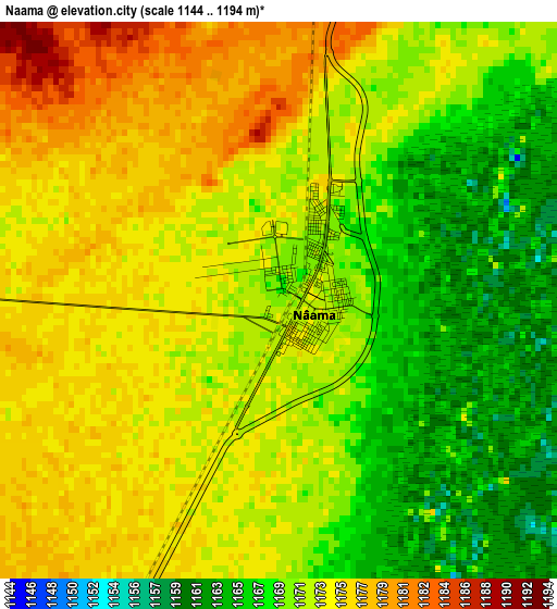
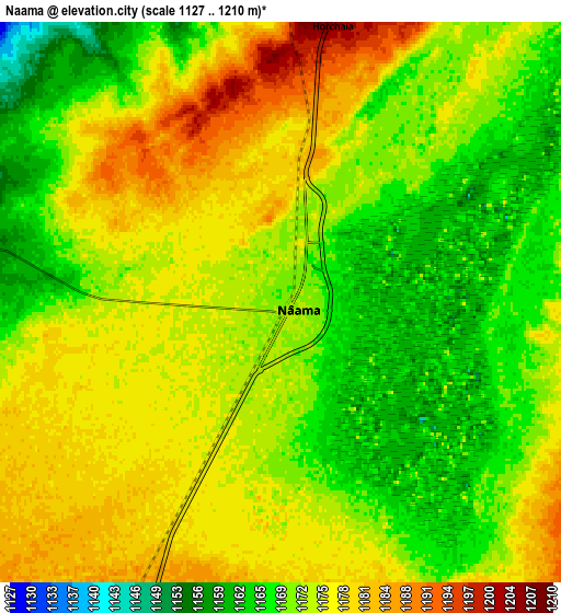
Below is the Elevation map of Naama, which displays elevation range with different colors. Scale of the first map is from 1144 to 1194 m (3753 to 3917 ft) with average elevation of 1171.4 meters (=3843 ft) [note 1]
These maps also provides idea of topography and contour of this city, they are displayed at different zoom levels. More info about maps, scale and edge coordinates you can find below images.
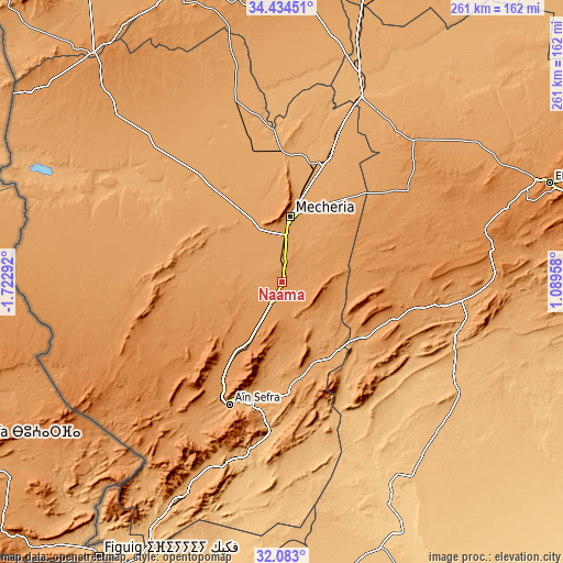
| \ | Map #1 | Map #2 | Topo.Map |
| Scale [m] | 1144..1194 m | 1127..1210 m | × |
| Scale [ft] | 3753..3917 ft | 3698..3970 ft | × |
| Average | 1171.4 m = 3843 ft | 1172.7 m = 3847 ft | × |
| Width | 8.17 km = 5.1 mi | 16.34 km = 10.2 mi | 261.5 km = 162.5 mi |
| Height | 8.17 km = 5.1 mi | 16.34 km = 10.2 mi | 261.5 km = 162.5 mi |
| ↑Max Latitude | 33.303406° | 33.340127° | 34.43451° |
| Latitude at center | 33.26667° | 33.26667° | 33.26667° |
| ↓Min Latitude | 33.229918° | 33.193151° | 32.083° |
| ← Min Longitude | -0.360615° | -0.404561° | -1.72292° |
| Longitude center | -0.31667° | -0.31667° | -0.31667° |
| →Max Longitude | -0.272725° | -0.228779° | 1.08958° |
Nearby cities:
Cities around Naama sort by population:
• Tlemcen elevation 811 m
201.4 km,  332°
332°
• Saïda 840 m
179.1 km,  13°
13°
• El Bayadh 1310 m
132.3 km,  69°
69°
• Aïn Sefra 1078 m
62.6 km,  203°
203°
• Mansoûra 894 m
200.8 km, 332°
• Sebdou 920 m
178.8 km, 328°
• Chetouane 578 m
204.8 km, 333°
• El Abiodh Sidi Cheikh 903 m
90.7 km,  117°
117°
• Ouled Mimoun 700 m
193.7 km,  340°
340°
• Brezina 855 m
148 km,  97°
97°
• ’Aïn el Hadjar 1024 m
171.2 km, 14°
• Sidi Senoussi سيدي سنوسي 589 m
205.3 km, 339°
Multilingual:
 En español:
Naama elevación 1169 m.
 En France:
Naama élévation 1169 m.


Sources and notes:
- [note 1] Map square and city borders are not equal. Map elevation data is calculated only from area inside that square.
- [src 1] Elevation data from geonames database provided with same terms of usage.
- [src 2] The elevation map of Naama is generated using elevation data from NASA's 3 arcsec (90m) resolution SRTM data.
- [src 3] Base (background) map © OpenStreetMap contributors tiles are generated by Geofabrik and OpenTopoMap.
Copyright & License:
This Naama Elevation Map is licensed under CC BY-SA. You may reuse any part from this page, if you give a proper credit by linking to this URL:
 More info on terms of use page.