El Bayadh elevation
El Bayadh, Algeria elevation is 1310 meters and El Bayadh elevation in feet is 4298 ft above sea level [src 1]. El Bayadh is a seat of a first-order administrative division (feature code) with elevation that is 872 meters (2861 ft) bigger than average city elevation in Algeria.
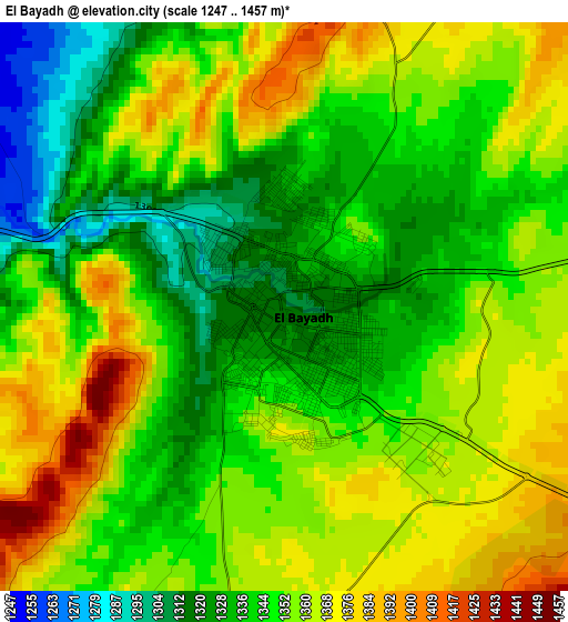
Below is the Elevation map of El Bayadh, which displays elevation range with different colors. Scale of the first map is from 1247 to 1457 m (4091 to 4780 ft) with average elevation of 1349.8 meters (=4428 ft) [note 1]
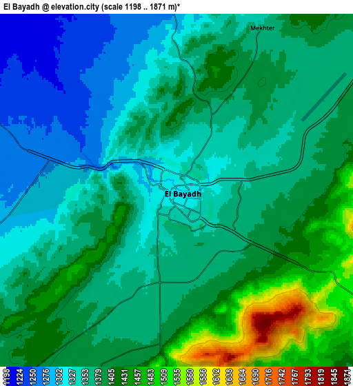
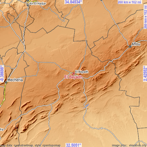
These maps also provides idea of topography and contour of this city, they are displayed at different zoom levels. More info about maps, scale and edge coordinates you can find below images.
| \ | Map #1 | Map #2 | Topo.Map |
| Scale [m] | 1247..1457 m | 1198..1871 m | × |
| Scale [ft] | 4091..4780 ft | 3930..6138 ft | × |
| Average | 1349.8 m = 4428 ft | 1374.5 m = 4510 ft | × |
| Width | 8.13 km = 5.1 mi | 16.26 km = 10.1 mi | 260.2 km = 161.7 mi |
| Height | 8.13 km = 5.1 mi | 16.26 km = 10.1 mi | 260.2 km = 161.7 mi |
| ↑Max Latitude | 33.71974° | 33.756284° | 34.84534° |
| Latitude at center | 33.68318° | 33.68318° | 33.68318° |
| ↓Min Latitude | 33.646605° | 33.610014° | 32.5051° |
| ← Min Longitude | 0.975325° | 0.931379° | -0.38698° |
| Longitude center | 1.01927° | 1.01927° | 1.01927° |
| →Max Longitude | 1.063215° | 1.107161° | 2.42552° |
Nearby cities:
Cities around El Bayadh sort by population:
• Saïda elevation 840 m
150.4 km,  327°
327°
• Laghouat 764 m
171.2 km,  85°
85°
• Aflou 1392 m
110.8 km,  64°
64°
• Sougueur 1133 m
172.7 km,  14°
14°
• Frenda 1058 m
153.7 km,  1°
1°
• El Abiodh Sidi Cheikh 903 m
98.2 km,  206°
206°
• El Idrissia 1070 m
162.7 km, 58°
• ’Aïn Deheb 1081 m
137.7 km,  20°
20°
• Brezina 855 m
68.7 km,  160°
160°
• ’Aïn el Hadjar 1024 m
144.1 km, 326°
• Naama 1169 m
132.3 km,  249°
249°
• Djebilet Rosfa 905 m
132.4 km,  352°
352°
Multilingual:
 En español:
El Bayadh elevación 1310 m.
 En France:
El-Bayadh élévation 1310 m.
 Auf Deutsch:
El Bayadh höhe über dem Meeresspiegel ist 1310 m.

Sources and notes:
- [note 1] Map square and city borders are not equal. Map elevation data is calculated only from area inside that square.
- [src 1] Elevation data from geonames database provided with same terms of usage.
- [src 2] The elevation map of El Bayadh is generated using elevation data from NASA's 3 arcsec (90m) resolution SRTM data.
- [src 3] Base (background) map © OpenStreetMap contributors tiles are generated by Geofabrik and OpenTopoMap.
Copyright & License:
This El Bayadh Elevation Map is licensed under CC BY-SA. You may reuse any part from this page, if you give a proper credit by linking to this URL:
 More info on terms of use page.