Laghouat elevation
Laghouat, Algeria elevation is 764 meters and Laghouat elevation in feet is 2507 ft above sea level [src 1]. Laghouat is a seat of a first-order administrative division (feature code) with elevation that is 326 meters (1070 ft) bigger than average city elevation in Algeria.
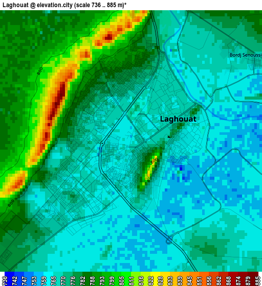
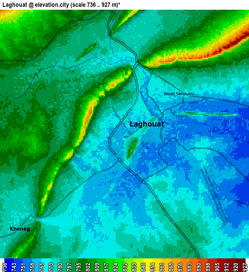
Below is the Elevation map of Laghouat, which displays elevation range with different colors. Scale of the first map is from 736 to 885 m (2415 to 2904 ft) with average elevation of 775.1 meters (=2543 ft) [note 1]
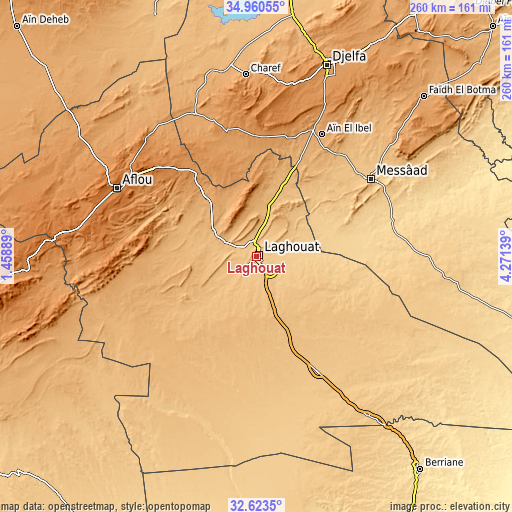
These maps also provides idea of topography and contour of this city, they are displayed at different zoom levels. More info about maps, scale and edge coordinates you can find below images.
| \ | Map #1 | Map #2 | Topo.Map |
| Scale [m] | 736..885 m | 736..927 m | × |
| Scale [ft] | 2415..2904 ft | 2415..3041 ft | × |
| Average | 775.1 m = 2543 ft | 782.4 m = 2567 ft | × |
| Width | 8.12 km = 5 mi | 16.24 km = 10.1 mi | 259.9 km = 161.5 mi |
| Height | 8.12 km = 5 mi | 16.24 km = 10.1 mi | 259.9 km = 161.5 mi |
| ↑Max Latitude | 33.83651° | 33.873005° | 34.96055° |
| Latitude at center | 33.8° | 33.8° | 33.8° |
| ↓Min Latitude | 33.763474° | 33.726933° | 32.6235° |
| ← Min Longitude | 2.821195° | 2.777249° | 1.45889° |
| Longitude center | 2.86514° | 2.86514° | 2.86514° |
| →Max Longitude | 2.909085° | 2.953031° | 4.27139° |
Nearby cities:
Cities around Laghouat sort by population:
• Djelfa elevation 1138 m
103.7 km,  20°
20°
• Messaad 777 m
70.8 km,  56°
56°
• Ghardaïa 503 m
163.9 km,  152°
152°
• Aflou 1392 m
78.5 km,  296°
296°
• Ksar Chellala 842 m
164.8 km,  342°
342°
• Dar Chioukh 1094 m
134.5 km,  25°
25°
• Berriane 536 m
136.9 km,  142°
142°
• ’Aïn el Melh 930 m
166.2 km,  45°
45°
• El Idrissia 1070 m
78.2 km, 336°
• ’Aïn Deheb 1081 m
167.6 km,  313°
313°
• ’Aïn el Bell 1008 m
68.9 km, 28°
• Charef 1157 m
91.5 km,  355°
355°
Multilingual:
 En español:
Laghouat elevación 764 m.
 En France:
Laghouat élévation 764 m.
 Auf Deutsch:
Laghouat höhe über dem Meeresspiegel ist 764 m.

Sources and notes:
- [note 1] Map square and city borders are not equal. Map elevation data is calculated only from area inside that square.
- [src 1] Elevation data from geonames database provided with same terms of usage.
- [src 2] The elevation map of Laghouat is generated using elevation data from NASA's 3 arcsec (90m) resolution SRTM data.
- [src 3] Base (background) map © OpenStreetMap contributors tiles are generated by Geofabrik and OpenTopoMap.
Copyright & License:
This Laghouat Elevation Map is licensed under CC BY-SA. You may reuse any part from this page, if you give a proper credit by linking to this URL:
 More info on terms of use page.