Aflou elevation
Aflou (Laghouat), Algeria elevation is 1392 meters and Aflou elevation in feet is 4567 ft above sea level [src 1]. Aflou is a populated place (feature code) with elevation that is 954 meters (3130 ft) bigger than average city elevation in Algeria.
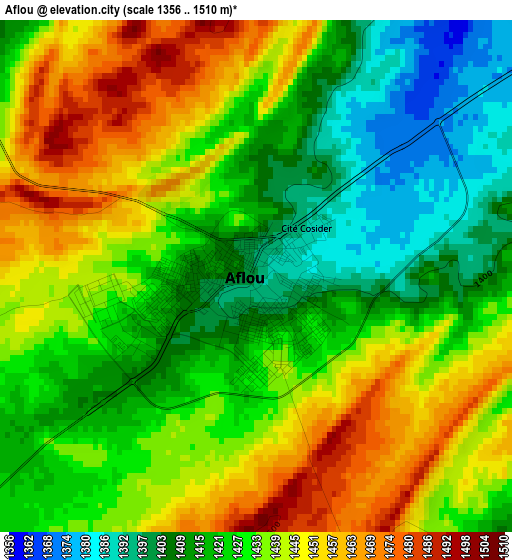
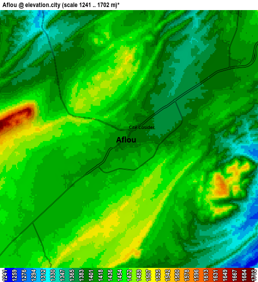
Below is the Elevation map of Aflou, which displays elevation range with different colors. Scale of the first map is from 1356 to 1510 m (4449 to 4954 ft) with average elevation of 1430.9 meters (=4695 ft) [note 1]
These maps also provides idea of topography and contour of this city, they are displayed at different zoom levels. More info about maps, scale and edge coordinates you can find below images.
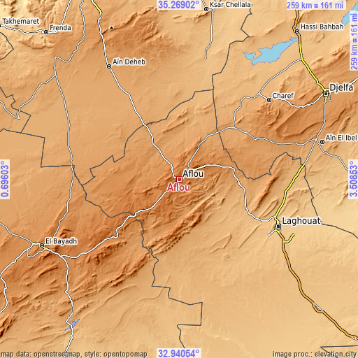
| \ | Map #1 | Map #2 | Topo.Map |
| Scale [m] | 1356..1510 m | 1241..1702 m | × |
| Scale [ft] | 4449..4954 ft | 4072..5584 ft | × |
| Average | 1430.9 m = 4695 ft | 1424.3 m = 4673 ft | × |
| Width | 8.09 km = 5 mi | 16.18 km = 10.1 mi | 258.9 km = 160.9 mi |
| Height | 8.09 km = 5 mi | 16.18 km = 10.1 mi | 258.9 km = 160.9 mi |
| ↑Max Latitude | 34.149166° | 34.185526° | 35.26902° |
| Latitude at center | 34.11279° | 34.11279° | 34.11279° |
| ↓Min Latitude | 34.076398° | 34.039991° | 32.94054° |
| ← Min Longitude | 2.058335° | 2.014389° | 0.69603° |
| Longitude center | 2.10228° | 2.10228° | 2.10228° |
| →Max Longitude | 2.146225° | 2.190171° | 3.50853° |
Nearby cities:
Cities around Aflou sort by population:
• Djelfa elevation 1138 m
123.4 km,  59°
59°
• Laghouat 764 m
78.5 km,  116°
116°
• Messaad 777 m
129 km,  87°
87°
• Sougueur 1133 m
131.5 km,  335°
335°
• El Bayadh 1310 m
110.8 km,  244°
244°
• Ksar Chellala 842 m
123.8 km,  9°
9°
• El Idrissia 1070 m
53.8 km,  46°
46°
• ’Aïn Deheb 1081 m
95.7 km,  327°
327°
• ’Aïn el Bell 1008 m
106.3 km,  76°
76°
• Charef 1157 m
85.1 km, 48°
• Brezina 855 m
137 km,  214°
214°
• Djebilet Rosfa 905 m
143 km,  305°
305°
Multilingual:
 En español:
Aflou elevación 1392 m.
 En France:
Aflou élévation 1392 m.


Sources and notes:
- [note 1] Map square and city borders are not equal. Map elevation data is calculated only from area inside that square.
- [src 1] Elevation data from geonames database provided with same terms of usage.
- [src 2] The elevation map of Aflou is generated using elevation data from NASA's 3 arcsec (90m) resolution SRTM data.
- [src 3] Base (background) map © OpenStreetMap contributors tiles are generated by Geofabrik and OpenTopoMap.
Copyright & License:
This Aflou Elevation Map is licensed under CC BY-SA. You may reuse any part from this page, if you give a proper credit by linking to this URL:
 More info on terms of use page.