Sidi Aïssa elevation
Sidi Aïssa (M'Sila), Algeria elevation is 662 meters and Sidi Aïssa elevation in feet is 2172 ft above sea level [src 1]. Sidi Aïssa is a populated place (feature code) with elevation that is 224 meters (735 ft) bigger than average city elevation in Algeria.
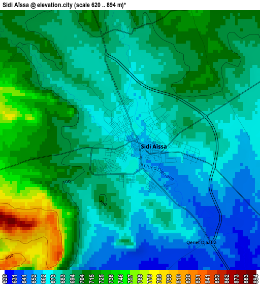
Below is the Elevation map of Sidi Aïssa, which displays elevation range with different colors. Scale of the first map is from 620 to 894 m (2034 to 2933 ft) with average elevation of 692.4 meters (=2272 ft) [note 1]
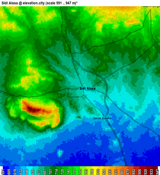
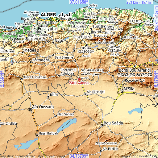
These maps also provides idea of topography and contour of this city, they are displayed at different zoom levels. More info about maps, scale and edge coordinates you can find below images.
| \ | Map #1 | Map #2 | Topo.Map |
| Scale [m] | 620..894 m | 591..947 m | × |
| Scale [ft] | 2034..2933 ft | 1939..3107 ft | × |
| Average | 692.4 m = 2272 ft | 693.5 m = 2275 ft | × |
| Width | 7.92 km = 4.9 mi | 15.84 km = 9.8 mi | 253.4 km = 157.5 mi |
| Height | 7.92 km = 4.9 mi | 15.84 km = 9.8 mi | 253.4 km = 157.5 mi |
| ↑Max Latitude | 35.921076° | 35.956656° | 37.01658° |
| Latitude at center | 35.88548° | 35.88548° | 35.88548° |
| ↓Min Latitude | 35.849868° | 35.81424° | 34.73799° |
| ← Min Longitude | 3.728415° | 3.684469° | 2.36611° |
| Longitude center | 3.77236° | 3.77236° | 3.77236° |
| →Max Longitude | 3.816305° | 3.860251° | 5.17861° |
Nearby cities:
Cities around Sidi Aïssa sort by population:
• M’Sila elevation 477 m
72.2 km,  106°
106°
• Boghni 249 m
74.8 km,  12°
12°
• Bouïra 519 m
55.6 km, 12°
• Birine 736 m
56.7 km,  240°
240°
• Sour el Ghozlane 884 m
30.1 km,  345°
345°
• ‘Aïn el Hadjel 544 m
25.9 km,  157°
157°
• Draa el Mizan 410 m
72.6 km,  4°
4°
• Aïn Bessem 677 m
46.2 km, 348°
• Melouza 936 m
38.8 km,  74°
74°
• Mansourah 667 m
65.1 km, 69°
• Chorfa 342 m
72.9 km,  43°
43°
• ’Aïn Boucif 1123 m
55.3 km,  270°
270°
Multilingual:
 En español:
Sidi Aïssa elevación 662 m.
 En France:
Sidi Aïssa élévation 662 m.
 Auf Deutsch:
Sidi Aïssa höhe über dem Meeresspiegel ist 662 m.

Sources and notes:
- [note 1] Map square and city borders are not equal. Map elevation data is calculated only from area inside that square.
- [src 1] Elevation data from geonames database provided with same terms of usage.
- [src 2] The elevation map of Sidi Aïssa is generated using elevation data from NASA's 3 arcsec (90m) resolution SRTM data.
- [src 3] Base (background) map © OpenStreetMap contributors tiles are generated by Geofabrik and OpenTopoMap.
Copyright & License:
This Sidi Aïssa Elevation Map is licensed under CC BY-SA. You may reuse any part from this page, if you give a proper credit by linking to this URL:
 More info on terms of use page.