Sour el Ghozlane elevation
Sour el Ghozlane (Bouira), Algeria elevation is 884 meters and Sour el Ghozlane elevation in feet is 2900 ft above sea level [src 1]. Sour el Ghozlane is a populated place (feature code) with elevation that is 446 meters (1463 ft) bigger than average city elevation in Algeria.
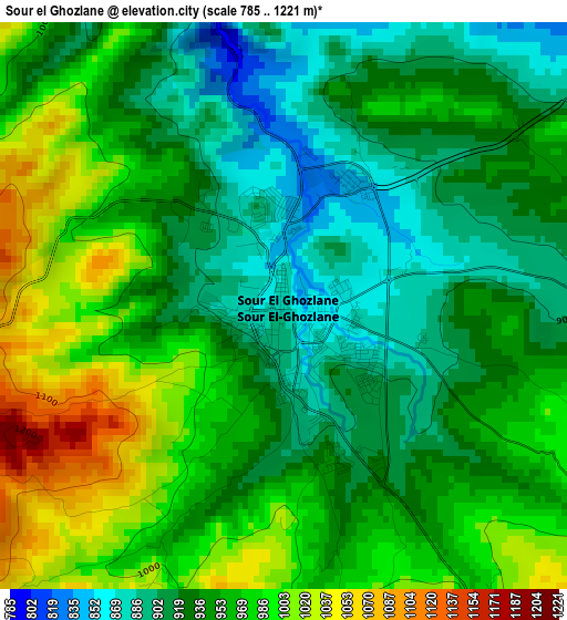
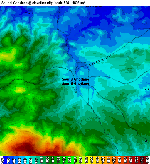
Below is the Elevation map of Sour el Ghozlane, which displays elevation range with different colors. Scale of the first map is from 785 to 1221 m (2575 to 4006 ft) with average elevation of 949.7 meters (=3116 ft) [note 1]
These maps also provides idea of topography and contour of this city, they are displayed at different zoom levels. More info about maps, scale and edge coordinates you can find below images.
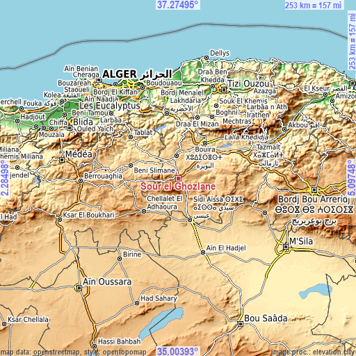
| \ | Map #1 | Map #2 | Topo.Map |
| Scale [m] | 785..1221 m | 724..1803 m | × |
| Scale [ft] | 2575..4006 ft | 2375..5915 ft | × |
| Average | 949.7 m = 3116 ft | 1012.1 m = 3321 ft | × |
| Width | 7.89 km = 4.9 mi | 15.78 km = 9.8 mi | 252.5 km = 156.9 mi |
| Height | 7.89 km = 4.9 mi | 15.78 km = 9.8 mi | 252.5 km = 156.9 mi |
| ↑Max Latitude | 36.183138° | 36.2186° | 37.27495° |
| Latitude at center | 36.14766° | 36.14766° | 36.14766° |
| ↓Min Latitude | 36.112166° | 36.076656° | 35.00393° |
| ← Min Longitude | 3.647285° | 3.603339° | 2.28498° |
| Longitude center | 3.69123° | 3.69123° | 3.69123° |
| →Max Longitude | 3.735175° | 3.779121° | 5.09748° |
Nearby cities:
Cities around Sour el Ghozlane sort by population:
• Sidi Aïssa elevation 662 m
30.1 km,  165°
165°
• Lakhdaria 171 m
47.2 km,  349°
349°
• Boghni 249 m
49.7 km,  28°
28°
• Bouïra 519 m
31.6 km,  36°
36°
• ‘Aïn el Hadjel 544 m
55.8 km,  162°
162°
• Draa el Mizan 410 m
45 km,  16°
16°
• Aïn Bessem 677 m
16.3 km, 354°
• Tizi Gheniff 370 m
49.6 km,  8°
8°
• Melouza 936 m
48.3 km,  112°
112°
• Tizi-n-Tleta 483 m
55.1 km, 36°
• Chabet el Ameur 245 m
54.4 km,  0°
0°
• ’Aïn Boucif 1123 m
55.8 km,  239°
239°
Multilingual:
 En español:
Sour el Ghozlane elevación 884 m.
 En France:
Sour el Ghozlane élévation 884 m.
 Auf Deutsch:
Sour el Ghozlane höhe über dem Meeresspiegel ist 884 m.

Sources and notes:
- [note 1] Map square and city borders are not equal. Map elevation data is calculated only from area inside that square.
- [src 1] Elevation data from geonames database provided with same terms of usage.
- [src 2] The elevation map of Sour el Ghozlane is generated using elevation data from NASA's 3 arcsec (90m) resolution SRTM data.
- [src 3] Base (background) map © OpenStreetMap contributors tiles are generated by Geofabrik and OpenTopoMap.
Copyright & License:
This Sour el Ghozlane Elevation Map is licensed under CC BY-SA. You may reuse any part from this page, if you give a proper credit by linking to this URL:
 More info on terms of use page.