Bouïra elevation
Bouïra (Bouira), Algeria elevation is 519 meters and Bouïra elevation in feet is 1703 ft above sea level [src 1]. Bouïra is a seat of a first-order administrative division (feature code) with elevation that is 81 meters (266 ft) bigger than average city elevation in Algeria.
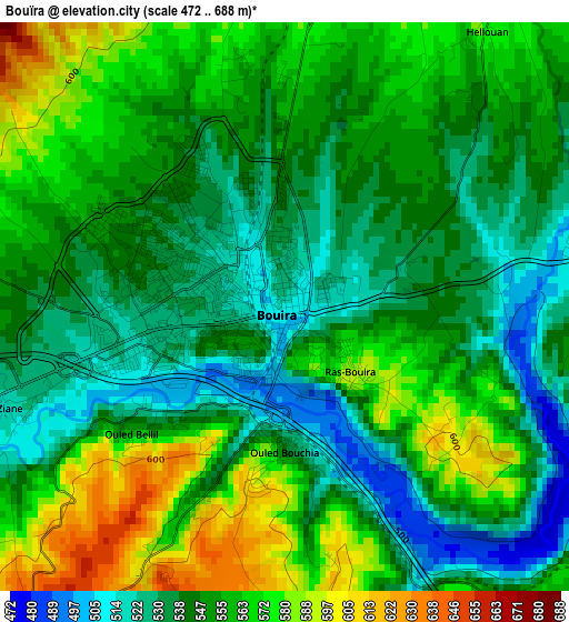
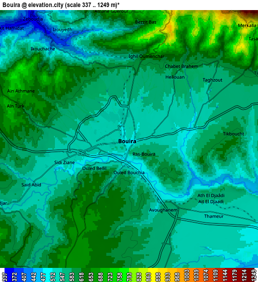
Below is the Elevation map of Bouïra, which displays elevation range with different colors. Scale of the first map is from 472 to 688 m (1549 to 2257 ft) with average elevation of 551.1 meters (=1808 ft) [note 1]
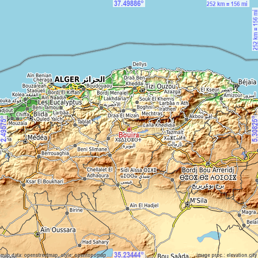
These maps also provides idea of topography and contour of this city, they are displayed at different zoom levels. More info about maps, scale and edge coordinates you can find below images.
| \ | Map #1 | Map #2 | Topo.Map |
| Scale [m] | 472..688 m | 337..1249 m | × |
| Scale [ft] | 1549..2257 ft | 1106..4098 ft | × |
| Average | 551.1 m = 1808 ft | 583.1 m = 1913 ft | × |
| Width | 7.87 km = 4.9 mi | 15.74 km = 9.8 mi | 251.8 km = 156.5 mi |
| Height | 7.87 km = 4.9 mi | 15.74 km = 9.8 mi | 251.8 km = 156.5 mi |
| ↑Max Latitude | 36.410265° | 36.445623° | 37.49886° |
| Latitude at center | 36.37489° | 36.37489° | 36.37489° |
| ↓Min Latitude | 36.339499° | 36.304092° | 35.23444° |
| ← Min Longitude | 3.858055° | 3.814109° | 2.49575° |
| Longitude center | 3.902° | 3.902° | 3.902° |
| →Max Longitude | 3.945945° | 3.989891° | 5.30825° |
Nearby cities:
Cities around Bouïra sort by population:
• Lakhdaria elevation 171 m
34.7 km,  307°
307°
• Boghni 249 m
19.2 km,  13°
13°
• Sour el Ghozlane 884 m
31.6 km,  216°
216°
• Draa el Mizan 410 m
19 km,  341°
341°
• Beni Douala 804 m
31.6 km,  30°
30°
• L’Arbaa Naït Irathen 710 m
38.9 km,  42°
42°
• Aïn Bessem 677 m
22.4 km,  246°
246°
• Tizi Gheniff 370 m
26.3 km,  334°
334°
• Tirmitine 532 m
31.8 km, 12°
• Tizi-n-Tleta 483 m
23.5 km, 36°
• Chorfa 342 m
38 km,  91°
91°
• Chabet el Ameur 245 m
34.5 km, 327°
Multilingual:
 En español:
Bouïra elevación 519 m.
 En France:
Bouïra élévation 519 m.


Sources and notes:
- [note 1] Map square and city borders are not equal. Map elevation data is calculated only from area inside that square.
- [src 1] Elevation data from geonames database provided with same terms of usage.
- [src 2] The elevation map of Bouïra is generated using elevation data from NASA's 3 arcsec (90m) resolution SRTM data.
- [src 3] Base (background) map © OpenStreetMap contributors tiles are generated by Geofabrik and OpenTopoMap.
Copyright & License:
This Bouïra Elevation Map is licensed under CC BY-SA. You may reuse any part from this page, if you give a proper credit by linking to this URL:
 More info on terms of use page.