Vallejuelo elevation
Vallejuelo (San Juan), Dominican Republic elevation is 675 meters and Vallejuelo elevation in feet is 2215 ft above sea level [src 1]. Vallejuelo is a populated place (feature code) with elevation that is 512 meters (1680 ft) bigger than average city elevation in Dominican Republic.
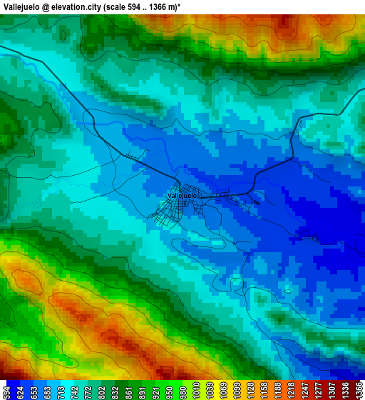
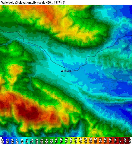
Below is the Elevation map of Vallejuelo, which displays elevation range with different colors. Scale of the first map is from 594 to 1366 m (1949 to 4482 ft) with average elevation of 807.1 meters (=2648 ft) [note 1]
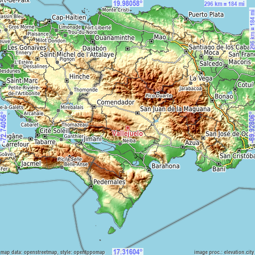
These maps also provides idea of topography and contour of this city, they are displayed at different zoom levels. More info about maps, scale and edge coordinates you can find below images.
| \ | Map #1 | Map #2 | Topo.Map |
| Scale [m] | 594..1366 m | 460..1817 m | × |
| Scale [ft] | 1949..4482 ft | 1509..5961 ft | × |
| Average | 807.1 m = 2648 ft | 938.8 m = 3080 ft | × |
| Width | 9.26 km = 5.8 mi | 18.52 km = 11.5 mi | 296.3 km = 184.1 mi |
| Height | 9.26 km = 5.8 mi | 18.52 km = 11.5 mi | 296.3 km = 184.1 mi |
| ↑Max Latitude | 18.695172° | 18.736793° | 19.98058° |
| Latitude at center | 18.65354° | 18.65354° | 18.65354° |
| ↓Min Latitude | 18.611898° | 18.570246° | 17.31604° |
| ← Min Longitude | -71.378255° | -71.422201° | -72.74056° |
| Longitude center | -71.33431° | -71.33431° | -71.33431° |
| →Max Longitude | -71.290365° | -71.246419° | -69.92806° |
Nearby cities:
Cities around Vallejuelo sort by population:
• San Juan de la Maguana elevation 418 m
20.2 km,  32°
32°
• Las Matas de Farfán 451 m
31 km,  321°
321°
• Neiba 25 m
21.2 km,  205°
205°
• Villa Jaragua 12 m
24 km,  221°
221°
• Galván 42 m
16.8 km,  183°
183°
• Juan de Herrera 477 m
26.5 km,  22°
22°
• Cercado Abajo 740 m
20.9 km,  292°
292°
• Los Ríos 34 m
30.8 km,  241°
241°
• Villarpando 287 m
31.1 km,  88°
88°
• El Palmar 14 m
28.5 km,  160°
160°
• Pedro Corto 502 m
23.1 km,  339°
339°
• Juan Santiago 807 m
27.5 km,  281°
281°
Multilingual:
 En español:
Vallejuelo elevación 675 m.
 En France:
Vallejuelo élévation 675 m.
 Auf Deutsch:
Vallejuelo höhe über dem Meeresspiegel ist 675 m.

Sources and notes:
- [note 1] Map square and city borders are not equal. Map elevation data is calculated only from area inside that square.
- [src 1] Elevation data from geonames database provided with same terms of usage.
- [src 2] The elevation map of Vallejuelo is generated using elevation data from NASA's 3 arcsec (90m) resolution SRTM data.
- [src 3] Base (background) map © OpenStreetMap contributors tiles are generated by Geofabrik and OpenTopoMap.
Copyright & License:
This Vallejuelo Elevation Map is licensed under CC BY-SA. You may reuse any part from this page, if you give a proper credit by linking to this URL:
 More info on terms of use page.