Las Matas de Farfán elevation
Las Matas de Farfán (San Juan), Dominican Republic elevation is 451 meters and Las Matas de Farfán elevation in feet is 1480 ft above sea level [src 1]. Las Matas de Farfán is a populated place (feature code) with elevation that is 288 meters (945 ft) bigger than average city elevation in Dominican Republic.
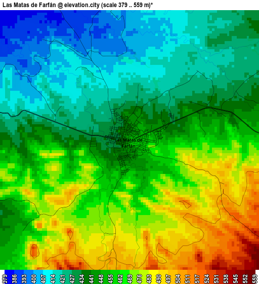
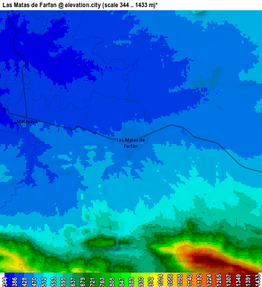
Below is the Elevation map of Las Matas de Farfán, which displays elevation range with different colors. Scale of the first map is from 379 to 559 m (1243 to 1834 ft) with average elevation of 449 meters (=1473 ft) [note 1]
These maps also provides idea of topography and contour of this city, they are displayed at different zoom levels. More info about maps, scale and edge coordinates you can find below images.
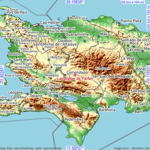
| \ | Map #1 | Map #2 | Topo.Map |
| Scale [m] | 379..559 m | 344..1433 m | × |
| Scale [ft] | 1243..1834 ft | 1129..4701 ft | × |
| Average | 449 m = 1473 ft | 503.1 m = 1651 ft | × |
| Width | 9.25 km = 5.7 mi | 18.49 km = 11.5 mi | 295.9 km = 183.9 mi |
| Height | 9.25 km = 5.7 mi | 18.49 km = 11.5 mi | 295.9 km = 183.9 mi |
| ↑Max Latitude | 18.914668° | 18.956235° | 20.19835° |
| Latitude at center | 18.87309° | 18.87309° | 18.87309° |
| ↓Min Latitude | 18.831502° | 18.789904° | 17.53727° |
| ← Min Longitude | -71.560505° | -71.604451° | -72.92281° |
| Longitude center | -71.51656° | -71.51656° | -71.51656° |
| →Max Longitude | -71.472615° | -71.428669° | -70.11031° |
Nearby cities:
Cities around Las Matas de Farfán sort by population:
• San Juan de la Maguana elevation 418 m
31.1 km,  103°
103°
• Comendador 394 m
19.6 km,  271°
271°
• Juan de Herrera 477 m
29.3 km,  89°
89°
• Cercado Abajo 740 m
16.3 km,  180°
180°
• Vallejuelo 675 m
31 km,  141°
141°
• Hondo Valle 899 m
25.7 km,  227°
227°
• El Llano 544 m
13.8 km,  242°
242°
• Pedro Corto 502 m
11.5 km, 103°
• Juan Santiago 807 m
20.4 km,  202°
202°
• Bánica 277 m
30.6 km,  319°
319°
• Pedro Santana 293 m
31.9 km, 323°
• Matayaya 418 m
8.4 km,  283°
283°
Multilingual:
 En español:
Las Matas de Farfán elevación 451 m.
 En France:
Las Matas de Farfán élévation 451 m.
 Auf Deutsch:
Las Matas de Farfán höhe über dem Meeresspiegel ist 451 m.
 На русском:
Лас-Матас-де-Фарфан высота над уровнем моря 451 м
Sources and notes:
- [note 1] Map square and city borders are not equal. Map elevation data is calculated only from area inside that square.
- [src 1] Elevation data from geonames database provided with same terms of usage.
- [src 2] The elevation map of Las Matas de Farfán is generated using elevation data from NASA's 3 arcsec (90m) resolution SRTM data.
- [src 3] Base (background) map © OpenStreetMap contributors tiles are generated by Geofabrik and OpenTopoMap.
Copyright & License:
This Las Matas de Farfán Elevation Map is licensed under CC BY-SA. You may reuse any part from this page, if you give a proper credit by linking to this URL:
 More info on terms of use page.