Comendador elevation
Comendador (Elías Piña), Dominican Republic elevation is 394 meters and Comendador elevation in feet is 1293 ft above sea level [src 1]. Comendador is a seat of a first-order administrative division (feature code) with elevation that is 231 meters (758 ft) bigger than average city elevation in Dominican Republic.
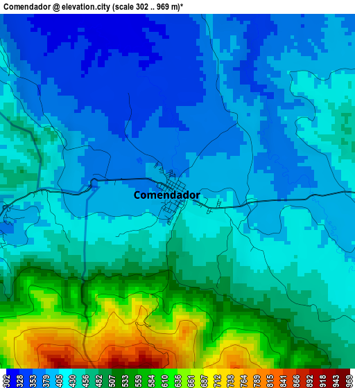
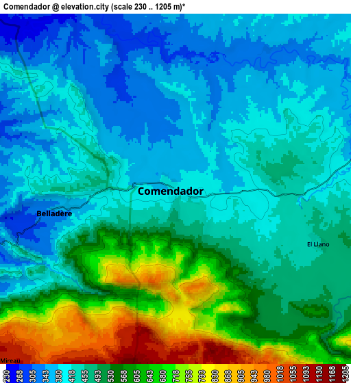
Below is the Elevation map of Comendador, which displays elevation range with different colors. Scale of the first map is from 302 to 969 m (991 to 3179 ft) with average elevation of 448 meters (=1470 ft) [note 1]
These maps also provides idea of topography and contour of this city, they are displayed at different zoom levels. More info about maps, scale and edge coordinates you can find below images.
| \ | Map #1 | Map #2 | Topo.Map |
| Scale [m] | 302..969 m | 230..1205 m | × |
| Scale [ft] | 991..3179 ft | 755..3953 ft | × |
| Average | 448 m = 1470 ft | 487.8 m = 1600 ft | × |
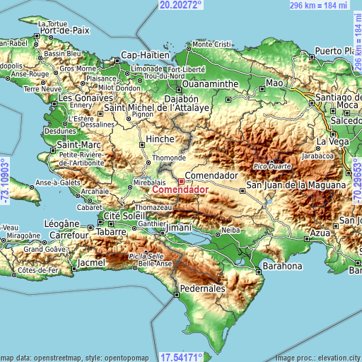
| Width | 9.25 km = 5.7 mi | 18.49 km = 11.5 mi | 295.9 km = 183.9 mi |
| Height | 9.25 km = 5.7 mi | 18.49 km = 11.5 mi | 295.9 km = 183.9 mi |
| ↑Max Latitude | 18.919076° | 18.960643° | 20.20272° |
| Latitude at center | 18.8775° | 18.8775° | 18.8775° |
| ↓Min Latitude | 18.835913° | 18.794316° | 17.54171° |
| ← Min Longitude | -71.746725° | -71.790671° | -73.10903° |
| Longitude center | -71.70278° | -71.70278° | -71.70278° |
| →Max Longitude | -71.658835° | -71.614889° | -70.29653° |
Nearby cities:
Cities around Comendador sort by population:
• Las Matas de Farfán elevation 451 m
19.6 km,  91°
91°
• La Descubierta 31 m
34.2 km,  184°
184°
• Cercado Abajo 740 m
25.7 km,  130°
130°
• Hondo Valle 899 m
18 km, 177°
• Postrer Río 16 m
37.8 km,  169°
169°
• El Llano 544 m
10 km, 132°
• Pedro Corto 502 m
30.9 km,  95°
95°
• Juan Santiago 807 m
22.7 km,  148°
148°
• Guayabal 253 m
31.7 km, 168°
• Bánica 277 m
22.8 km,  359°
359°
• Pedro Santana 293 m
25.3 km,  1°
1°
• Matayaya 418 m
11.5 km,  82°
82°
Multilingual:
 En español:
Comendador elevación 394 m.
 En France:
Comendador élévation 394 m.
 Auf Deutsch:
Comendador höhe über dem Meeresspiegel ist 394 m.

Sources and notes:
- [note 1] Map square and city borders are not equal. Map elevation data is calculated only from area inside that square.
- [src 1] Elevation data from geonames database provided with same terms of usage.
- [src 2] The elevation map of Comendador is generated using elevation data from NASA's 3 arcsec (90m) resolution SRTM data.
- [src 3] Base (background) map © OpenStreetMap contributors tiles are generated by Geofabrik and OpenTopoMap.
Copyright & License:
This Comendador Elevation Map is licensed under CC BY-SA. You may reuse any part from this page, if you give a proper credit by linking to this URL:
 More info on terms of use page.