Los Ríos elevation
Los Ríos (Baoruco), Dominican Republic elevation is 34 meters and Los Ríos elevation in feet is 112 ft above sea level [src 1]. Los Ríos is a populated place (feature code) with elevation that is 129 meters (423 ft) smaller than average city elevation in Dominican Republic.
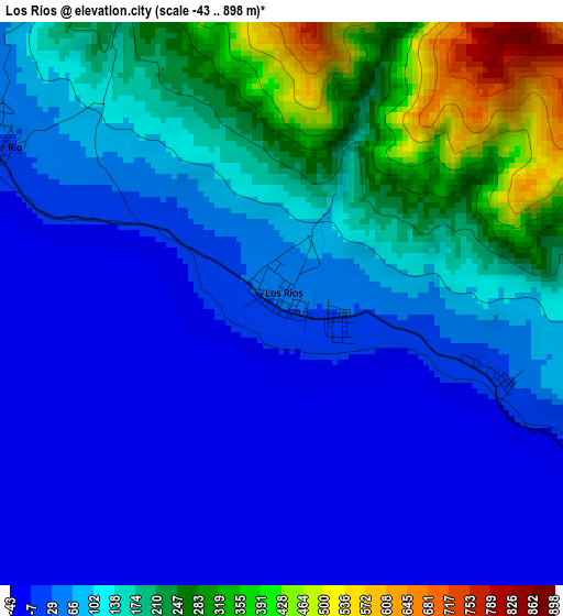
Below is the Elevation map of Los Ríos, which displays elevation range with different colors. Scale of the first map is from -43 to 898 m (-141 to 2946 ft) with average elevation of 101.8 meters (=334 ft) [note 1]
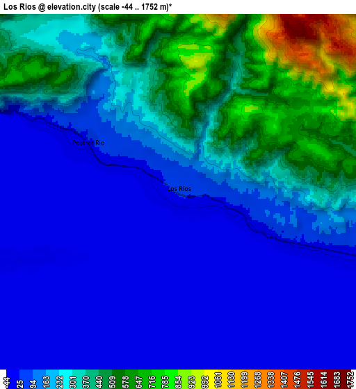
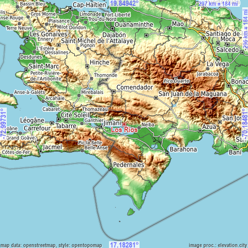
These maps also provides idea of topography and contour of this city, they are displayed at different zoom levels. More info about maps, scale and edge coordinates you can find below images.
| \ | Map #1 | Map #2 | Topo.Map |
| Scale [m] | -43..898 m | -44..1752 m | × |
| Scale [ft] | -141..2946 ft | -144..5748 ft | × |
| Average | 101.8 m = 334 ft | 218 m = 715 ft | × |
| Width | 9.27 km = 5.8 mi | 18.53 km = 11.5 mi | 296.5 km = 184.2 mi |
| Height | 9.27 km = 5.8 mi | 18.53 km = 11.5 mi | 296.5 km = 184.2 mi |
| ↑Max Latitude | 18.562974° | 18.604628° | 19.84942° |
| Latitude at center | 18.52131° | 18.52131° | 18.52131° |
| ↓Min Latitude | 18.479636° | 18.437951° | 17.18281° |
| ← Min Longitude | -71.635005° | -71.678951° | -72.99731° |
| Longitude center | -71.59106° | -71.59106° | -71.59106° |
| →Max Longitude | -71.547115° | -71.503169° | -70.18481° |
Nearby cities:
Cities around Los Ríos sort by population:
• Neiba elevation 25 m
18.6 km,  103°
103°
• Duvergé 9 m
17.4 km,  156°
156°
• Villa Jaragua 12 m
11.8 km,  106°
106°
• Jimaní 48 m
27.5 km,  263°
263°
• Galván 42 m
26.3 km,  94°
94°
• La Descubierta 31 m
15.6 km,  290°
290°
• Cercado Abajo 740 m
24.1 km,  18°
18°
• Hondo Valle 899 m
24.3 km,  333°
333°
• Postrer Río 16 m
5.3 km,  297°
297°
• Mella 9 m
25.8 km,  134°
134°
• Juan Santiago 807 m
20.2 km,  0°
0°
• Guayabal 253 m
10.1 km, 327°
Multilingual:
 En español:
Los Ríos elevación 34 m.
 En France:
Los Ríos élévation 34 m.


Sources and notes:
- [note 1] Map square and city borders are not equal. Map elevation data is calculated only from area inside that square.
- [src 1] Elevation data from geonames database provided with same terms of usage.
- [src 2] The elevation map of Los Ríos is generated using elevation data from NASA's 3 arcsec (90m) resolution SRTM data.
- [src 3] Base (background) map © OpenStreetMap contributors tiles are generated by Geofabrik and OpenTopoMap.
Copyright & License:
This Los Ríos Elevation Map is licensed under CC BY-SA. You may reuse any part from this page, if you give a proper credit by linking to this URL:
 More info on terms of use page.