Neiba elevation
Neiba (Baoruco), Dominican Republic elevation is 25 meters and Neiba elevation in feet is 82 ft above sea level [src 1]. Neiba is a seat of a first-order administrative division (feature code) with elevation that is 138 meters (453 ft) smaller than average city elevation in Dominican Republic.
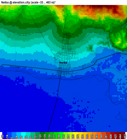
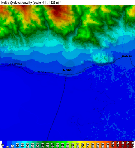
Below is the Elevation map of Neiba, which displays elevation range with different colors. Scale of the first map is from -33 to 463 m (-108 to 1519 ft) with average elevation of 54.4 meters (=178 ft) [note 1]
These maps also provides idea of topography and contour of this city, they are displayed at different zoom levels. More info about maps, scale and edge coordinates you can find below images.
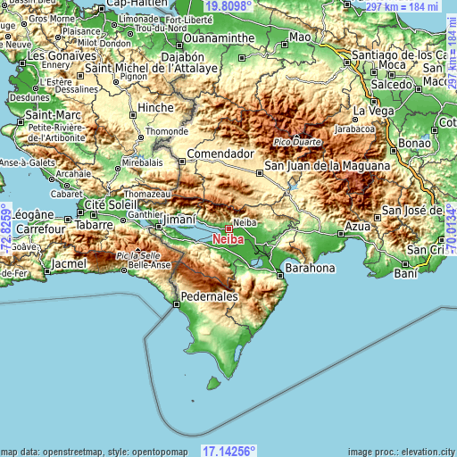
| \ | Map #1 | Map #2 | Topo.Map |
| Scale [m] | -33..463 m | -41..1228 m | × |
| Scale [ft] | -108..1519 ft | -135..4029 ft | × |
| Average | 54.4 m = 178 ft | 149 m = 489 ft | × |
| Width | 9.27 km = 5.8 mi | 18.54 km = 11.5 mi | 296.6 km = 184.3 mi |
| Height | 9.27 km = 5.8 mi | 18.54 km = 11.5 mi | 296.6 km = 184.3 mi |
| ↑Max Latitude | 18.523044° | 18.564708° | 19.8098° |
| Latitude at center | 18.48137° | 18.48137° | 18.48137° |
| ↓Min Latitude | 18.439686° | 18.397992° | 17.14256° |
| ← Min Longitude | -71.463595° | -71.507541° | -72.8259° |
| Longitude center | -71.41965° | -71.41965° | -71.41965° |
| →Max Longitude | -71.375705° | -71.331759° | -70.0134° |
Nearby cities:
Cities around Neiba sort by population:
• Duvergé elevation 9 m
15.9 km,  224°
224°
• Villa Jaragua 12 m
6.8 km,  278°
278°
• Tamayo 32 m
24.8 km,  112°
112°
• Galván 42 m
8.4 km,  74°
74°
• Vallejuelo 675 m
21.2 km,  25°
25°
• Las Salinas 31 m
25.4 km,  154°
154°
• Los Ríos 34 m
18.6 km, 283°
• Postrer Río 16 m
23.8 km,  286°
286°
• Cristóbal 14 m
24.7 km, 147°
• El Palmar 14 m
19.9 km, 112°
• La Uvilla 26 m
25.8 km,  121°
121°
• Mella 9 m
13.6 km,  178°
178°
Multilingual:
 En español:
Neiba elevación 25 m.
 En France:
Neiba élévation 25 m.


Sources and notes:
- [note 1] Map square and city borders are not equal. Map elevation data is calculated only from area inside that square.
- [src 1] Elevation data from geonames database provided with same terms of usage.
- [src 2] The elevation map of Neiba is generated using elevation data from NASA's 3 arcsec (90m) resolution SRTM data.
- [src 3] Base (background) map © OpenStreetMap contributors tiles are generated by Geofabrik and OpenTopoMap.
Copyright & License:
This Neiba Elevation Map is licensed under CC BY-SA. You may reuse any part from this page, if you give a proper credit by linking to this URL:
 More info on terms of use page.