Mespelbrunn elevation
Mespelbrunn (Bavaria, Regierungsbezirk Unterfranken), Germany elevation is 278 meters and Mespelbrunn elevation in feet is 912 ft above sea level [src 1]. Mespelbrunn is a seat of a fourth-order administrative division (feature code) with elevation that is 20 meters (66 ft) bigger than average city elevation in Germany.
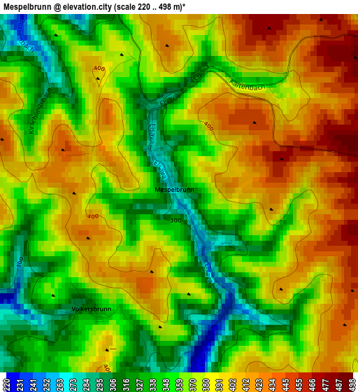
Below is the Elevation map of Mespelbrunn, which displays elevation range with different colors. Scale of the first map is from 220 to 498 m (722 to 1634 ft) with average elevation of 373.3 meters (=1225 ft) [note 1]
These maps also provides idea of topography and contour of this city, they are displayed at different zoom levels. More info about maps, scale and edge coordinates you can find below images.
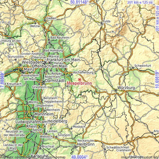
| \ | Map #1 | Topo.Map |
| Scale [m] | 220..498 m | × |
| Scale [ft] | 722..1634 ft | × |
| Average | 373.3 m = 1225 ft | × |
| Width | 6.29 km = 3.9 mi | 201.4 km = 125.1 mi |
| Height | 6.29 km = 3.9 mi | 201.4 km = 125.1 mi |
| ↑Max Latitude | 49.942729° | 50.81148° |
| Latitude at center | 49.91444° | 49.91444° |
| ↓Min Latitude | 49.886134° | 49.0004° |
| ← Min Longitude | 9.247995° | 7.88569° |
| Longitude center | 9.29194° | 9.29194° |
| →Max Longitude | 9.335885° | 10.69819° |
Nearby cities:
Cities around Mespelbrunn sort by population:
• Haibach elevation 279 m
8.2 km,  312°
312°
• Sulzbach am Main 129 m
9.9 km,  268°
268°
• Kleinwallstadt 124 m
9.8 km,  243°
243°
• Leidersbach 188 m
5.2 km,  253°
253°
• Niedernberg 122 m
11.1 km, 268°
• Eschau 177 m
10.9 km,  192°
192°
• Großwallstadt 127 m
10.7 km, 248°
• Waldaschaff 220 m
6.8 km,  6°
6°
• Heimbuchenthal 230 m
2.8 km,  174°
174°
• Weibersbrunn 361 m
5.6 km,  71°
71°
• Hausen 185 m
7.7 km,  229°
229°
• Rothenbuch 385 m
9.2 km,  52°
52°
Multilingual:
 En español:
Mespelbrunn elevación 278 m.
 En France:
Mespelbrunn élévation 278 m.
 Auf Deutsch:
Mespelbrunn höhe über dem Meeresspiegel ist 278 m.

Sources and notes:
- [note 1] Map square and city borders are not equal. Map elevation data is calculated only from area inside that square.
- [src 1] Elevation data from geonames database provided with same terms of usage.
- [src 2] The elevation map of Mespelbrunn is generated using elevation data from NASA's 3 arcsec (90m) resolution SRTM data.
- [src 3] Base (background) map © OpenStreetMap contributors tiles are generated by Geofabrik and OpenTopoMap.
Copyright & License:
This Mespelbrunn Elevation Map is licensed under CC BY-SA. You may reuse any part from this page, if you give a proper credit by linking to this URL:
 More info on terms of use page.