Giesen elevation
Giesen (Lower Saxony), Germany elevation is 81 meters and Giesen elevation in feet is 266 ft above sea level [src 1]. Giesen is a seat of a fourth-order administrative division (feature code) with elevation that is 177 meters (581 ft) smaller than average city elevation in Germany.
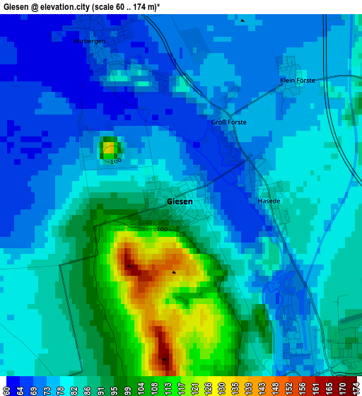
Below is the Elevation map of Giesen, which displays elevation range with different colors. Scale of the first map is from 60 to 174 m (197 to 571 ft) with average elevation of 82.9 meters (=272 ft) [note 1]
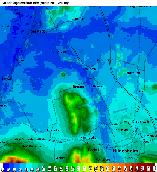
These maps also provides idea of topography and contour of this city, they are displayed at different zoom levels. More info about maps, scale and edge coordinates you can find below images.
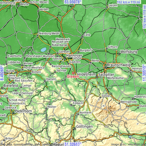
| \ | Map #1 | Map #2 | Topo.Map |
| Scale [m] | 60..174 m | 50..260 m | × |
| Scale [ft] | 197..571 ft | 164..853 ft | × |
| Average | 82.9 m = 272 ft | 82.7 m = 271 ft | × |
| Width | 5.99 km = 3.7 mi | 11.98 km = 7.4 mi | 191.7 km = 119.1 mi |
| Height | 5.99 km = 3.7 mi | 11.98 km = 7.4 mi | 191.7 km = 119.1 mi |
| ↑Max Latitude | 52.224088° | 52.251° | 53.05078° |
| Latitude at center | 52.19716° | 52.19716° | 52.19716° |
| ↓Min Latitude | 52.170216° | 52.143255° | 51.32683° |
| ← Min Longitude | 9.854955° | 9.811009° | 8.49265° |
| Longitude center | 9.8989° | 9.8989° | 9.8989° |
| →Max Longitude | 9.942845° | 9.986791° | 11.30515° |
Nearby cities:
Cities around Giesen sort by population:
• Hildesheim elevation 92 m
6.3 km,  145°
145°
• Sehnde 66 m
13.8 km,  19°
19°
• Sarstedt 65 m
5.2 km,  324°
324°
• Pattensen 67 m
11.8 km,  309°
309°
• Nordstemmen 76 m
8.8 km,  243°
243°
• Harsum 81 m
4.7 km,  71°
71°
• Hohenhameln 104 m
13.1 km,  59°
59°
• Schellerten 91 m
13.9 km,  95°
95°
• Algermissen 79 m
7.9 km,  37°
37°
• Diekholzen 122 m
11.3 km,  172°
172°
• Betheln 105 m
11.7 km,  217°
217°
• Heyersum 96 m
7.4 km,  232°
232°
Multilingual:
 En español:
Giesen elevación 81 m.
 En France:
Giesen élévation 81 m.


Sources and notes:
- [note 1] Map square and city borders are not equal. Map elevation data is calculated only from area inside that square.
- [src 1] Elevation data from geonames database provided with same terms of usage.
- [src 2] The elevation map of Giesen is generated using elevation data from NASA's 3 arcsec (90m) resolution SRTM data.
- [src 3] Base (background) map © OpenStreetMap contributors tiles are generated by Geofabrik and OpenTopoMap.
Copyright & License:
This Giesen Elevation Map is licensed under CC BY-SA. You may reuse any part from this page, if you give a proper credit by linking to this URL:
 More info on terms of use page.