Sarstedt elevation
Sarstedt (Lower Saxony), Germany elevation is 65 meters and Sarstedt elevation in feet is 213 ft above sea level [src 1]. Sarstedt is a populated place (feature code) with elevation that is 193 meters (633 ft) smaller than average city elevation in Germany.
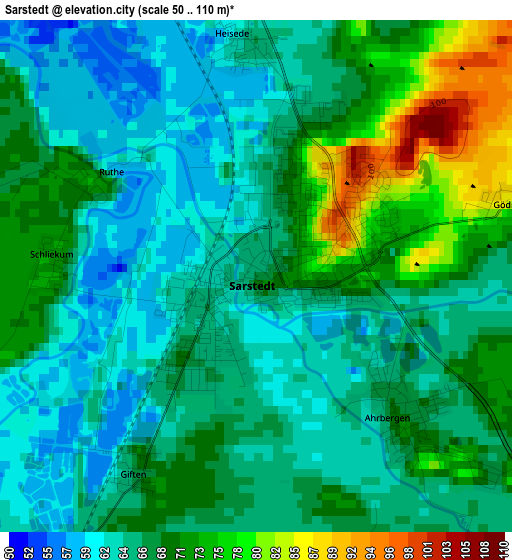
Below is the Elevation map of Sarstedt, which displays elevation range with different colors. Scale of the first map is from 50 to 110 m (164 to 361 ft) with average elevation of 67.6 meters (=222 ft) [note 1]
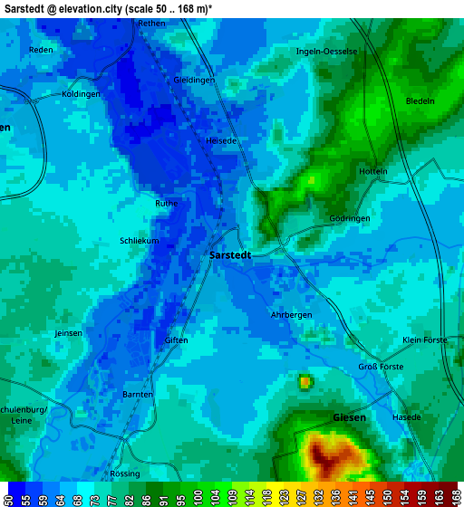
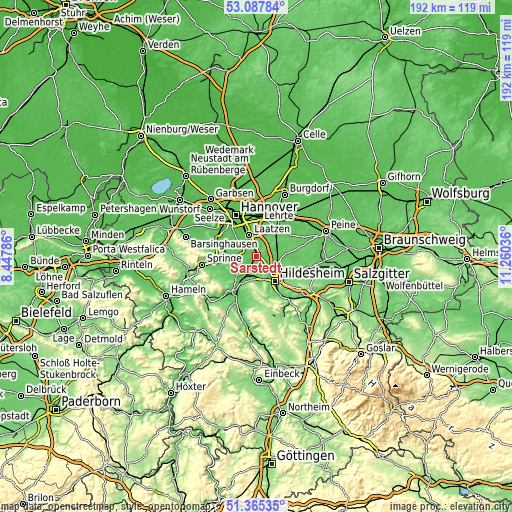
These maps also provides idea of topography and contour of this city, they are displayed at different zoom levels. More info about maps, scale and edge coordinates you can find below images.
| \ | Map #1 | Map #2 | Topo.Map |
| Scale [m] | 50..110 m | 50..168 m | × |
| Scale [ft] | 164..361 ft | 164..551 ft | × |
| Average | 67.6 m = 222 ft | 72.5 m = 238 ft | × |
| Width | 5.98 km = 3.7 mi | 11.97 km = 7.4 mi | 191.5 km = 119 mi |
| Height | 5.98 km = 3.7 mi | 11.97 km = 7.4 mi | 191.5 km = 119 mi |
| ↑Max Latitude | 52.261855° | 52.288744° | 53.08784° |
| Latitude at center | 52.23495° | 52.23495° | 52.23495° |
| ↓Min Latitude | 52.208029° | 52.181091° | 51.36535° |
| ← Min Longitude | 9.810165° | 9.766219° | 8.44786° |
| Longitude center | 9.85411° | 9.85411° | 9.85411° |
| →Max Longitude | 9.898055° | 9.942001° | 11.26036° |
Nearby cities:
Cities around Sarstedt sort by population:
• Hildesheim elevation 92 m
11.5 km,  144°
144°
• Laatzen 71 m
9.7 km,  336°
336°
• Sehnde 66 m
11.7 km,  41°
41°
• Hemmingen 57 m
12.5 km,  314°
314°
• Pattensen 67 m
6.9 km,  298°
298°
• Nordstemmen 76 m
9.4 km,  210°
210°
• Harsum 81 m
8 km,  109°
109°
• Giesen 81 m
5.2 km, 144°
• Hohenhameln 104 m
14.5 km,  80°
80°
• Algermissen 79 m
8.1 km, 75°
• Betheln 105 m
14 km,  196°
196°
• Heyersum 96 m
9.1 km, 198°
Multilingual:
 En español:
Sarstedt elevación 65 m.
 En France:
Sarstedt élévation 65 m.


Sources and notes:
- [note 1] Map square and city borders are not equal. Map elevation data is calculated only from area inside that square.
- [src 1] Elevation data from geonames database provided with same terms of usage.
- [src 2] The elevation map of Sarstedt is generated using elevation data from NASA's 3 arcsec (90m) resolution SRTM data.
- [src 3] Base (background) map © OpenStreetMap contributors tiles are generated by Geofabrik and OpenTopoMap.
Copyright & License:
This Sarstedt Elevation Map is licensed under CC BY-SA. You may reuse any part from this page, if you give a proper credit by linking to this URL:
 More info on terms of use page.