Adorf elevation
Adorf (Saxony), Germany elevation is 443 meters and Adorf elevation in feet is 1453 ft above sea level [src 1]. Adorf is a populated place (feature code) with elevation that is 185 meters (607 ft) bigger than average city elevation in Germany.
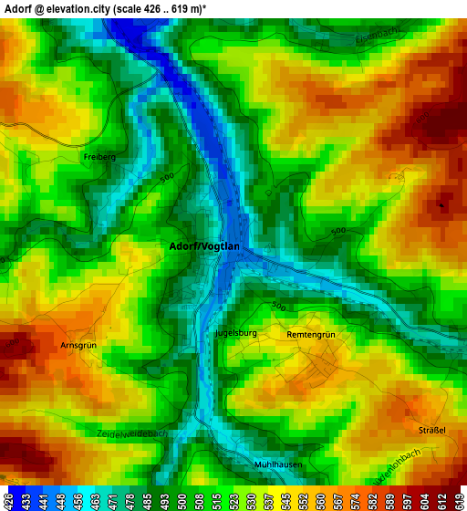
Below is the Elevation map of Adorf, which displays elevation range with different colors. Scale of the first map is from 426 to 619 m (1398 to 2031 ft) with average elevation of 521.5 meters (=1711 ft) [note 1]
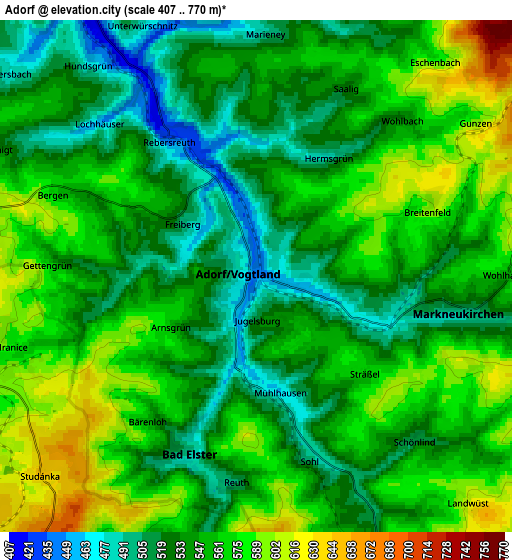
These maps also provides idea of topography and contour of this city, they are displayed at different zoom levels. More info about maps, scale and edge coordinates you can find below images.
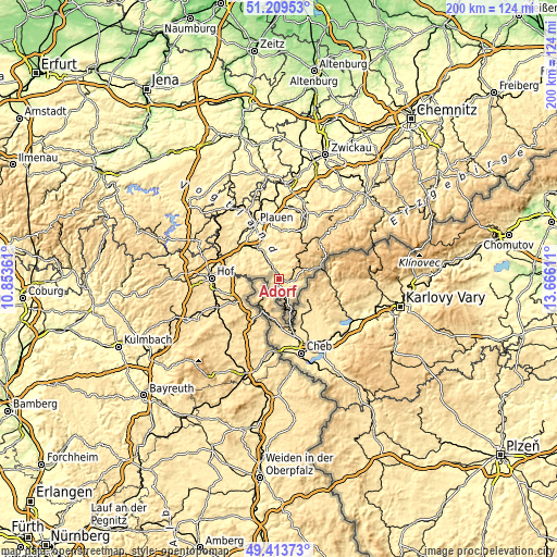
| \ | Map #1 | Map #2 | Topo.Map |
| Scale [m] | 426..619 m | 407..770 m | × |
| Scale [ft] | 1398..2031 ft | 1335..2526 ft | × |
| Average | 521.5 m = 1711 ft | 549.8 m = 1804 ft | × |
| Width | 6.24 km = 3.9 mi | 12.48 km = 7.8 mi | 199.7 km = 124.1 mi |
| Height | 6.24 km = 3.9 mi | 12.48 km = 7.8 mi | 199.7 km = 124.1 mi |
| ↑Max Latitude | 50.348161° | 50.376195° | 51.20953° |
| Latitude at center | 50.32011° | 50.32011° | 50.32011° |
| ↓Min Latitude | 50.292043° | 50.263959° | 49.41373° |
| ← Min Longitude | 12.215915° | 12.171969° | 10.85361° |
| Longitude center | 12.25986° | 12.25986° | 12.25986° |
| →Max Longitude | 12.303805° | 12.347751° | 13.66611° |
Nearby cities:
Cities around Adorf sort by population:
• Oelsnitz elevation 397 m
12.3 km,  328°
328°
• Markneukirchen 500 m
5 km,  101°
101°
• Bad Elster 507 m
4.6 km,  203°
203°
• Schöneck 701 m
9.2 km,  31°
31°
• Pöhl 721 m
9.5 km, 31°
• Bad Brambach 579 m
12.2 km,  160°
160°
• Erlbach 567 m
7.6 km,  92°
92°
• Werda 619 m
13.5 km,  13°
13°
• Triebel 467 m
11.4 km,  300°
300°
• Tirpersdorf 480 m
12.6 km,  356°
356°
• Zwota 596 m
12 km,  73°
73°
• Eichigt 555 m
7.4 km, 296°
Multilingual:
 En español:
Adorf elevación 443 m.
 En France:
Adorf élévation 443 m.


Sources and notes:
- [note 1] Map square and city borders are not equal. Map elevation data is calculated only from area inside that square.
- [src 1] Elevation data from geonames database provided with same terms of usage.
- [src 2] The elevation map of Adorf is generated using elevation data from NASA's 3 arcsec (90m) resolution SRTM data.
- [src 3] Base (background) map © OpenStreetMap contributors tiles are generated by Geofabrik and OpenTopoMap.
Copyright & License:
This Adorf Elevation Map is licensed under CC BY-SA. You may reuse any part from this page, if you give a proper credit by linking to this URL:
 More info on terms of use page.