Ahaus elevation
Ahaus (North Rhine-Westphalia, Regierungsbezirk Münster), Germany elevation is 50 meters and Ahaus elevation in feet is 164 ft above sea level [src 1]. Ahaus is a populated place (feature code) with elevation that is 208 meters (682 ft) smaller than average city elevation in Germany.
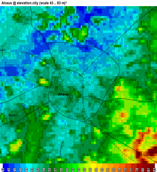
Below is the Elevation map of Ahaus, which displays elevation range with different colors. Scale of the first map is from 43 to 83 m (141 to 272 ft) with average elevation of 54.2 meters (=178 ft) [note 1]
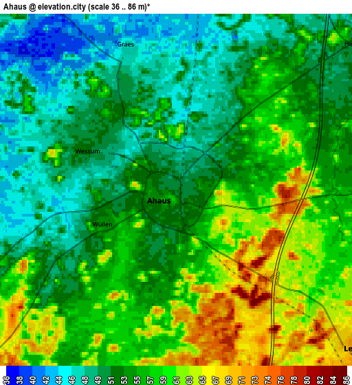
These maps also provides idea of topography and contour of this city, they are displayed at different zoom levels. More info about maps, scale and edge coordinates you can find below images.
| \ | Map #1 | Map #2 | Topo.Map |
| Scale [m] | 43..83 m | 36..86 m | × |
| Scale [ft] | 141..272 ft | 118..282 ft | × |
| Average | 54.2 m = 178 ft | 55 m = 180 ft | × |
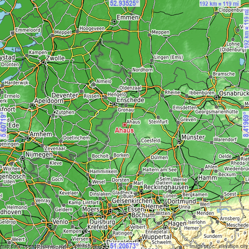
| Width | 6.01 km = 3.7 mi | 12.01 km = 7.5 mi | 192.2 km = 119.4 mi |
| Height | 6.01 km = 3.7 mi | 12.01 km = 7.5 mi | 192.2 km = 119.4 mi |
| ↑Max Latitude | 52.106359° | 52.133342° | 52.93525° |
| Latitude at center | 52.07936° | 52.07936° | 52.07936° |
| ↓Min Latitude | 52.052344° | 52.025312° | 51.20673° |
| ← Min Longitude | 6.969495° | 6.925549° | 5.60719° |
| Longitude center | 7.01344° | 7.01344° | 7.01344° |
| →Max Longitude | 7.057385° | 7.101331° | 8.41969° |
Nearby cities:
Cities around Ahaus sort by population:
• Gronau elevation 42 m
14.6 km,  2°
2°
• Coesfeld 83 m
18.4 km,  144°
144°
• Vreden 41 m
13.5 km,  250°
250°
• Stadtlohn 49 m
11.5 km,  214°
214°
• Ochtrup 61 m
18.7 km,  40°
40°
• Gescher 62 m
14 km,  182°
182°
• Südlohn 51 m
19.1 km, 211°
• Heek 52 m
7.2 km,  54°
54°
• Schöppingen 86 m
15.2 km,  81°
81°
• Horstmar 104 m
20 km,  89°
89°
• Legden 70 m
7.8 km,  130°
130°
• Metelen 59 m
15.4 km,  62°
62°
Multilingual:
 En español:
Ahaus elevación 50 m.
 En France:
Ahaus élévation 50 m.


Sources and notes:
- [note 1] Map square and city borders are not equal. Map elevation data is calculated only from area inside that square.
- [src 1] Elevation data from geonames database provided with same terms of usage.
- [src 2] The elevation map of Ahaus is generated using elevation data from NASA's 3 arcsec (90m) resolution SRTM data.
- [src 3] Base (background) map © OpenStreetMap contributors tiles are generated by Geofabrik and OpenTopoMap.
Copyright & License:
This Ahaus Elevation Map is licensed under CC BY-SA. You may reuse any part from this page, if you give a proper credit by linking to this URL:
 More info on terms of use page.