Aichhalden elevation
Aichhalden (Baden-Württemberg, Freiburg Region), Germany elevation is 705 meters and Aichhalden elevation in feet is 2313 ft above sea level [src 1]. Aichhalden is a seat of a fourth-order administrative division (feature code) with elevation that is 447 meters (1467 ft) bigger than average city elevation in Germany.
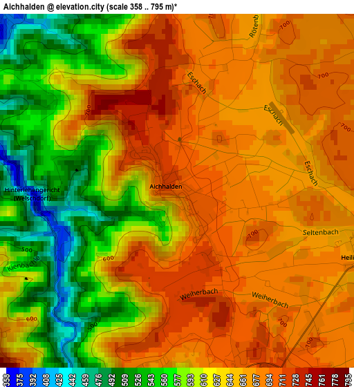
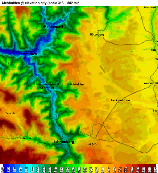
Below is the Elevation map of Aichhalden, which displays elevation range with different colors. Scale of the first map is from 358 to 795 m (1175 to 2608 ft) with average elevation of 638.1 meters (=2094 ft) [note 1]
These maps also provides idea of topography and contour of this city, they are displayed at different zoom levels. More info about maps, scale and edge coordinates you can find below images.
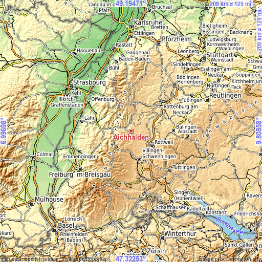
| \ | Map #1 | Map #2 | Topo.Map |
| Scale [m] | 358..795 m | 313..882 m | × |
| Scale [ft] | 1175..2608 ft | 1027..2894 ft | × |
| Average | 638.1 m = 2094 ft | 638 m = 2093 ft | × |
| Width | 6.51 km = 4 mi | 13.01 km = 8.1 mi | 208.2 km = 129.4 mi |
| Height | 6.51 km = 4 mi | 13.01 km = 8.1 mi | 208.2 km = 129.4 mi |
| ↑Max Latitude | 48.296434° | 48.325662° | 49.19471° |
| Latitude at center | 48.26719° | 48.26719° | 48.26719° |
| ↓Min Latitude | 48.237929° | 48.208651° | 47.32253° |
| ← Min Longitude | 8.358385° | 8.314439° | 6.99608° |
| Longitude center | 8.40233° | 8.40233° | 8.40233° |
| →Max Longitude | 8.446275° | 8.490221° | 9.80858° |
Nearby cities:
Cities around Aichhalden sort by population:
• Schramberg elevation 436 m
5 km,  194°
194°
• Oberndorf 510 m
12.8 km,  78°
78°
• Alpirsbach 434 m
8.7 km,  359°
359°
• Dornhan 642 m
12.1 km,  40°
40°
• Dunningen 659 m
9.8 km,  128°
128°
• Schiltach 334 m
5.1 km,  298°
298°
• Tennenbronn 663 m
9.3 km,  203°
203°
• Bösingen 658 m
11.6 km,  109°
109°
• Lauterbach/Schwarzwald 615 m
6.1 km,  227°
227°
• Hardt 773 m
9.4 km,  173°
173°
• Seedorf 661 m
6.8 km, 107°
• Schenkenzell 361 m
5.5 km,  335°
335°
Multilingual:
 En español:
Aichhalden elevación 705 m.
 En France:
Aichhalden élévation 705 m.
 Auf Deutsch:
Aichhalden höhe über dem Meeresspiegel ist 705 m.

Sources and notes:
- [note 1] Map square and city borders are not equal. Map elevation data is calculated only from area inside that square.
- [src 1] Elevation data from geonames database provided with same terms of usage.
- [src 2] The elevation map of Aichhalden is generated using elevation data from NASA's 3 arcsec (90m) resolution SRTM data.
- [src 3] Base (background) map © OpenStreetMap contributors tiles are generated by Geofabrik and OpenTopoMap.
Copyright & License:
This Aichhalden Elevation Map is licensed under CC BY-SA. You may reuse any part from this page, if you give a proper credit by linking to this URL:
 More info on terms of use page.