Dunningen elevation
Dunningen (Baden-Württemberg, Freiburg Region), Germany elevation is 659 meters and Dunningen elevation in feet is 2162 ft above sea level [src 1]. Dunningen is a seat of a fourth-order administrative division (feature code) with elevation that is 401 meters (1316 ft) bigger than average city elevation in Germany.
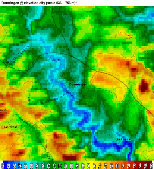
Below is the Elevation map of Dunningen, which displays elevation range with different colors. Scale of the first map is from 633 to 753 m (2077 to 2470 ft) with average elevation of 684 meters (=2244 ft) [note 1]
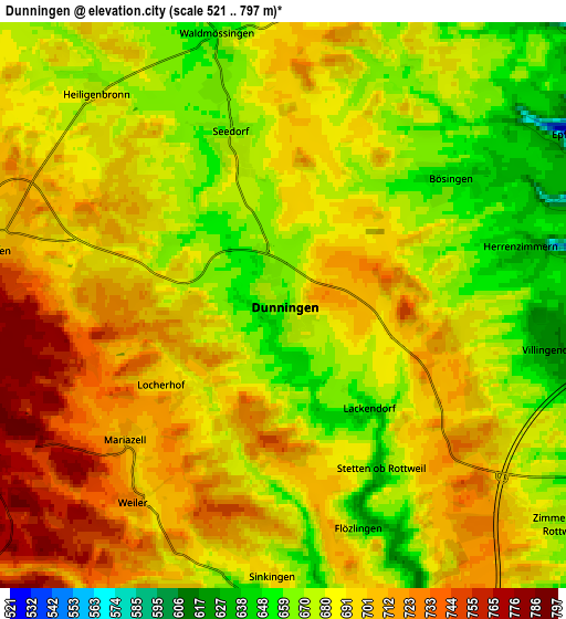
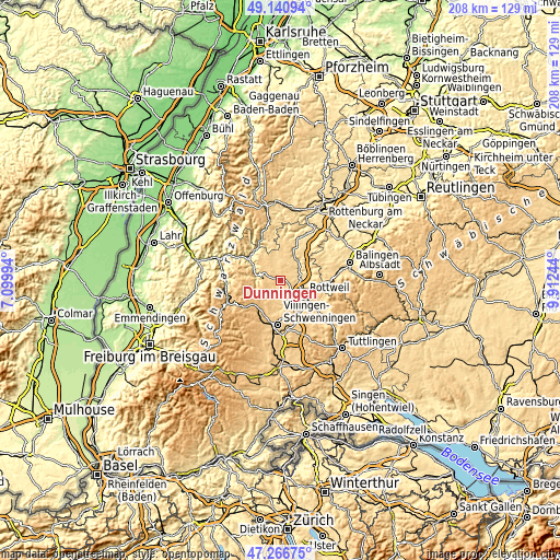
These maps also provides idea of topography and contour of this city, they are displayed at different zoom levels. More info about maps, scale and edge coordinates you can find below images.
| \ | Map #1 | Map #2 | Topo.Map |
| Scale [m] | 633..753 m | 521..797 m | × |
| Scale [ft] | 2077..2470 ft | 1709..2615 ft | × |
| Average | 684 m = 2244 ft | 691 m = 2267 ft | × |
| Width | 6.51 km = 4 mi | 13.02 km = 8.1 mi | 208.4 km = 129.5 mi |
| Height | 6.51 km = 4 mi | 13.02 km = 8.1 mi | 208.4 km = 129.5 mi |
| ↑Max Latitude | 48.241696° | 48.270954° | 49.14094° |
| Latitude at center | 48.21242° | 48.21242° | 48.21242° |
| ↓Min Latitude | 48.183128° | 48.153819° | 47.26675° |
| ← Min Longitude | 8.462245° | 8.418299° | 7.09994° |
| Longitude center | 8.50619° | 8.50619° | 8.50619° |
| →Max Longitude | 8.550135° | 8.594081° | 9.91244° |
Nearby cities:
Cities around Dunningen sort by population:
• Rottweil elevation 605 m
10.2 km,  118°
118°
• Schramberg 436 m
9 km,  278°
278°
• Oberndorf 510 m
10 km,  29°
29°
• Königsfeld im Schwarzwald 761 m
10.5 km,  217°
217°
• Zimmern ob Rottweil 663 m
8.3 km,  127°
127°
• Niedereschach 659 m
9 km,  167°
167°
• Aichhalden 705 m
9.8 km,  308°
308°
• Epfendorf 482 m
8.1 km,  58°
58°
• Bösingen 658 m
4 km,  54°
54°
• Villingendorf 640 m
5.9 km,  103°
103°
• Hardt 773 m
7.4 km,  244°
244°
• Seedorf 661 m
4.3 km,  343°
343°
Multilingual:
 En español:
Dunningen elevación 659 m.
 En France:
Dunningen élévation 659 m.
 Auf Deutsch:
Dunningen höhe über dem Meeresspiegel ist 659 m.

Sources and notes:
- [note 1] Map square and city borders are not equal. Map elevation data is calculated only from area inside that square.
- [src 1] Elevation data from geonames database provided with same terms of usage.
- [src 2] The elevation map of Dunningen is generated using elevation data from NASA's 3 arcsec (90m) resolution SRTM data.
- [src 3] Base (background) map © OpenStreetMap contributors tiles are generated by Geofabrik and OpenTopoMap.
Copyright & License:
This Dunningen Elevation Map is licensed under CC BY-SA. You may reuse any part from this page, if you give a proper credit by linking to this URL:
 More info on terms of use page.