Alsfeld elevation
Alsfeld (Hesse, Regierungsbezirk Gießen), Germany elevation is 273 meters and Alsfeld elevation in feet is 896 ft above sea level [src 1]. Alsfeld is a populated place (feature code) with elevation that is 15 meters (49 ft) bigger than average city elevation in Germany.
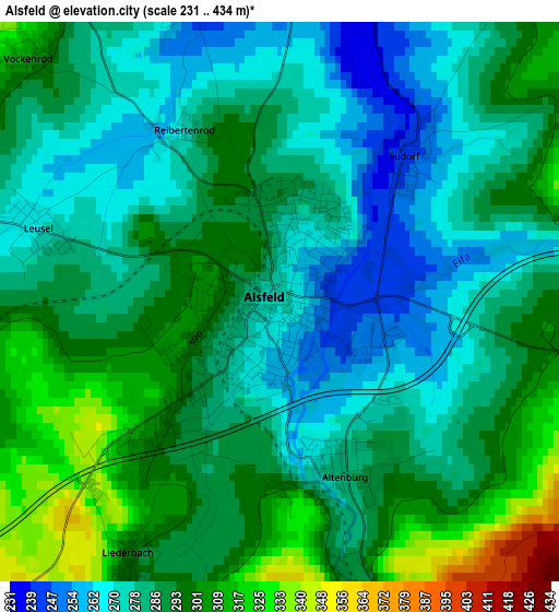
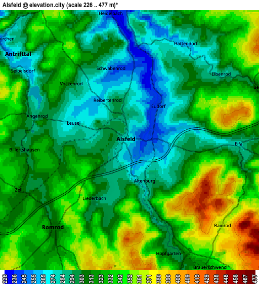
Below is the Elevation map of Alsfeld, which displays elevation range with different colors. Scale of the first map is from 231 to 434 m (758 to 1424 ft) with average elevation of 287.5 meters (=943 ft) [note 1]
These maps also provides idea of topography and contour of this city, they are displayed at different zoom levels. More info about maps, scale and edge coordinates you can find below images.
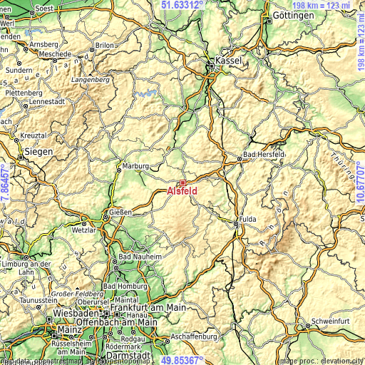
| \ | Map #1 | Map #2 | Topo.Map |
| Scale [m] | 231..434 m | 226..477 m | × |
| Scale [ft] | 758..1424 ft | 741..1565 ft | × |
| Average | 287.5 m = 943 ft | 318 m = 1043 ft | × |
| Width | 6.18 km = 3.8 mi | 12.37 km = 7.7 mi | 197.9 km = 123 mi |
| Height | 6.18 km = 3.8 mi | 12.37 km = 7.7 mi | 197.8 km = 122.9 mi |
| ↑Max Latitude | 50.779645° | 50.807424° | 51.63312° |
| Latitude at center | 50.75185° | 50.75185° | 50.75185° |
| ↓Min Latitude | 50.724038° | 50.69621° | 49.85367° |
| ← Min Longitude | 9.226875° | 9.182929° | 7.86457° |
| Longitude center | 9.27082° | 9.27082° | 9.27082° |
| →Max Longitude | 9.314765° | 9.358711° | 10.67707° |
Nearby cities:
Cities around Alsfeld sort by population:
• Lauterbach elevation 291 m
15.7 km,  145°
145°
• Neustadt (Hessen) 243 m
15.4 km,  315°
315°
• Neukirchen 263 m
14.1 km,  22°
22°
• Willingshausen 230 m
12 km,  335°
335°
• Kirtorf 266 m
11.9 km,  279°
279°
• Oberaula 333 m
17.6 km,  51°
51°
• Schrecksbach 225 m
9.1 km,  5°
5°
• Schwalmtal 348 m
8.5 km,  206°
206°
• Romrod 310 m
5.6 km,  219°
219°
• Grebenau 264 m
14.3 km,  94°
94°
• Lautertal 519 m
18.8 km,  177°
177°
• Ottrau 340 m
10.1 km, 53°
Multilingual:
 En español:
Alsfeld elevación 273 m.
 En France:
Alsfeld élévation 273 m.


Sources and notes:
- [note 1] Map square and city borders are not equal. Map elevation data is calculated only from area inside that square.
- [src 1] Elevation data from geonames database provided with same terms of usage.
- [src 2] The elevation map of Alsfeld is generated using elevation data from NASA's 3 arcsec (90m) resolution SRTM data.
- [src 3] Base (background) map © OpenStreetMap contributors tiles are generated by Geofabrik and OpenTopoMap.
Copyright & License:
This Alsfeld Elevation Map is licensed under CC BY-SA. You may reuse any part from this page, if you give a proper credit by linking to this URL:
 More info on terms of use page.