Ottrau elevation
Ottrau (Hesse, Regierungsbezirk Kassel), Germany elevation is 340 meters and Ottrau elevation in feet is 1115 ft above sea level [src 1]. Ottrau is a seat of a fourth-order administrative division (feature code) with elevation that is 82 meters (269 ft) bigger than average city elevation in Germany.
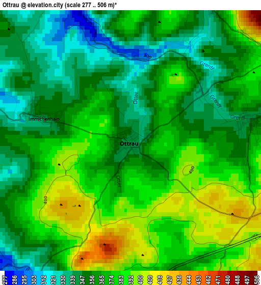
Below is the Elevation map of Ottrau, which displays elevation range with different colors. Scale of the first map is from 277 to 506 m (909 to 1660 ft) with average elevation of 366.6 meters (=1203 ft) [note 1]
These maps also provides idea of topography and contour of this city, they are displayed at different zoom levels. More info about maps, scale and edge coordinates you can find below images.
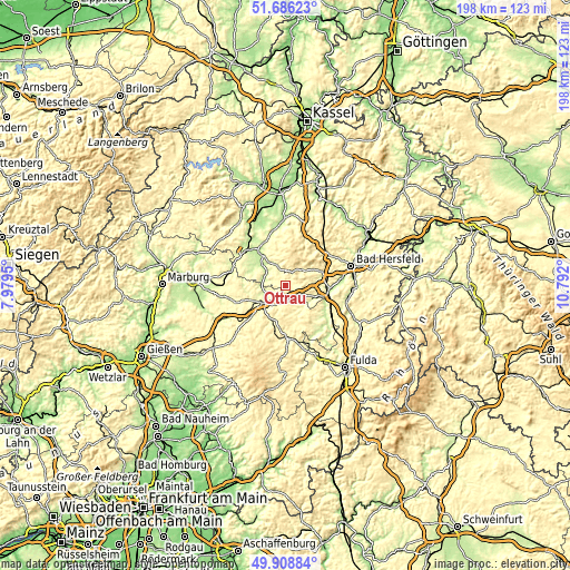
| \ | Map #1 | Topo.Map |
| Scale [m] | 277..506 m | × |
| Scale [ft] | 909..1660 ft | × |
| Average | 366.6 m = 1203 ft | × |
| Width | 6.18 km = 3.8 mi | 197.6 km = 122.8 mi |
| Height | 6.18 km = 3.8 mi | 197.6 km = 122.8 mi |
| ↑Max Latitude | 50.833753° | 51.68623° |
| Latitude at center | 50.80599° | 50.80599° |
| ↓Min Latitude | 50.778211° | 49.90884° |
| ← Min Longitude | 9.341805° | 7.9795° |
| Longitude center | 9.38575° | 9.38575° |
| →Max Longitude | 9.429695° | 10.792° |
Nearby cities:
Cities around Ottrau sort by population:
• Schwalmstadt elevation 235 m
18.5 km,  320°
320°
• Alsfeld 273 m
10.1 km,  233°
233°
• Neukirchen 263 m
7.5 km,  338°
338°
• Niederaula 213 m
15.1 km,  92°
92°
• Willingshausen 230 m
13.9 km,  290°
290°
• Kirchheim 246 m
13.1 km,  76°
76°
• Oberaula 333 m
7.5 km,  49°
49°
• Schrecksbach 225 m
7.8 km, 292°
• Schwalmtal 348 m
18.1 km,  221°
221°
• Romrod 310 m
15.5 km, 228°
• Grebenau 264 m
9.4 km,  139°
139°
• Schwarzenborn 484 m
12.3 km,  20°
20°
Multilingual:
 En español:
Ottrau elevación 340 m.
 En France:
Ottrau élévation 340 m.


Sources and notes:
- [note 1] Map square and city borders are not equal. Map elevation data is calculated only from area inside that square.
- [src 1] Elevation data from geonames database provided with same terms of usage.
- [src 2] The elevation map of Ottrau is generated using elevation data from NASA's 3 arcsec (90m) resolution SRTM data.
- [src 3] Base (background) map © OpenStreetMap contributors tiles are generated by Geofabrik and OpenTopoMap.
Copyright & License:
This Ottrau Elevation Map is licensed under CC BY-SA. You may reuse any part from this page, if you give a proper credit by linking to this URL:
 More info on terms of use page.