Aufseß elevation
Aufseß (Bavaria, Upper Franconia), Germany elevation is 411 meters and Aufseß elevation in feet is 1348 ft above sea level [src 1]. Aufseß is a seat of a fourth-order administrative division (feature code) with elevation that is 153 meters (502 ft) bigger than average city elevation in Germany.
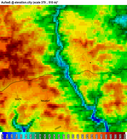
Below is the Elevation map of Aufseß, which displays elevation range with different colors. Scale of the first map is from 379 to 510 m (1243 to 1673 ft) with average elevation of 456.1 meters (=1496 ft) [note 1]
These maps also provides idea of topography and contour of this city, they are displayed at different zoom levels. More info about maps, scale and edge coordinates you can find below images.
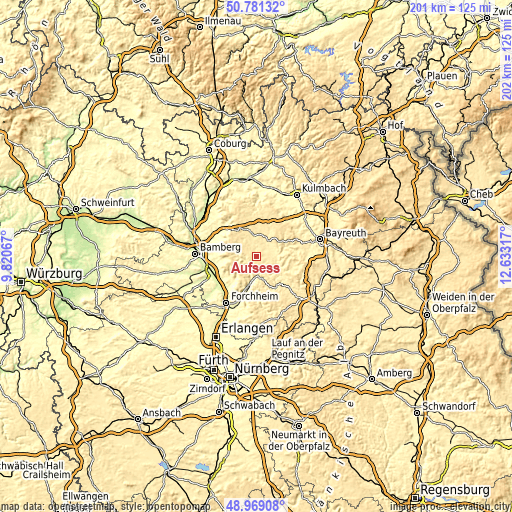
| \ | Map #1 | Topo.Map |
| Scale [m] | 379..510 m | × |
| Scale [ft] | 1243..1673 ft | × |
| Average | 456.1 m = 1496 ft | × |
| Width | 6.3 km = 3.9 mi | 201.5 km = 125.2 mi |
| Height | 6.3 km = 3.9 mi | 201.5 km = 125.2 mi |
| ↑Max Latitude | 49.912007° | 50.78132° |
| Latitude at center | 49.8837° | 49.8837° |
| ↓Min Latitude | 49.855376° | 48.96908° |
| ← Min Longitude | 11.182975° | 9.82067° |
| Longitude center | 11.22692° | 11.22692° |
| →Max Longitude | 11.270865° | 12.63317° |
Nearby cities:
Cities around Aufseß sort by population:
• Ebermannstadt elevation 297 m
11.8 km,  195°
195°
• Hollfeld 405 m
7.6 km,  37°
37°
• Gößweinstein 465 m
15.1 km,  147°
147°
• Heiligenstadt 356 m
4.6 km,  239°
239°
• Waischenfeld 365 m
9.6 km,  115°
115°
• Pretzfeld 289 m
14.8 km,  194°
194°
• Glashütten 423 m
15.9 km,  88°
88°
• Poxdorf 501 m
9.5 km,  307°
307°
• Königsfeld 450 m
8.2 km,  327°
327°
• Stadelhofen 480 m
13.4 km,  351°
351°
• Unterleinleiter 326 m
7.3 km, 201°
• Wonsees 416 m
11.5 km,  27°
27°
Multilingual:
 En español:
Aufseß elevación 411 m.
 En France:
Aufseß élévation 411 m.


Sources and notes:
- [note 1] Map square and city borders are not equal. Map elevation data is calculated only from area inside that square.
- [src 1] Elevation data from geonames database provided with same terms of usage.
- [src 2] The elevation map of Aufseß is generated using elevation data from NASA's 3 arcsec (90m) resolution SRTM data.
- [src 3] Base (background) map © OpenStreetMap contributors tiles are generated by Geofabrik and OpenTopoMap.
Copyright & License:
This Aufseß Elevation Map is licensed under CC BY-SA. You may reuse any part from this page, if you give a proper credit by linking to this URL:
 More info on terms of use page.