Bad Reichenhall elevation
Bad Reichenhall (Bavaria, Upper Bavaria), Germany elevation is 470 meters and Bad Reichenhall elevation in feet is 1542 ft above sea level [src 1]. Bad Reichenhall is a seat of a third-order administrative division (feature code) with elevation that is 212 meters (696 ft) bigger than average city elevation in Germany.
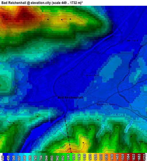
Below is the Elevation map of Bad Reichenhall, which displays elevation range with different colors. Scale of the first map is from 449 to 1732 m (1473 to 5682 ft) with average elevation of 700.4 meters (=2298 ft) [note 1]
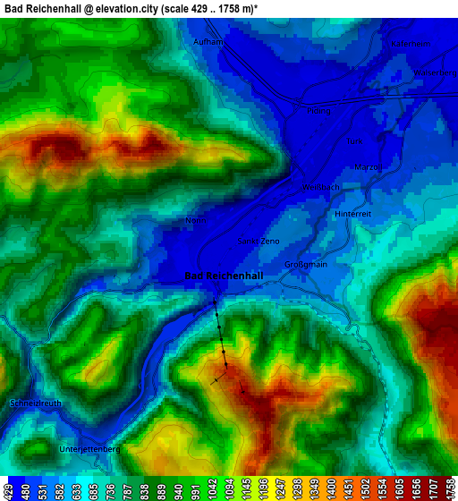
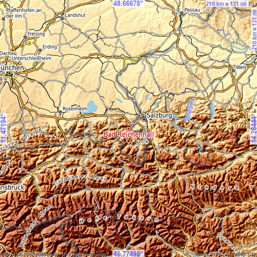
These maps also provides idea of topography and contour of this city, they are displayed at different zoom levels. More info about maps, scale and edge coordinates you can find below images.
| \ | Map #1 | Map #2 | Topo.Map |
| Scale [m] | 449..1732 m | 429..1758 m | × |
| Scale [ft] | 1473..5682 ft | 1407..5768 ft | × |
| Average | 700.4 m = 2298 ft | 815 m = 2674 ft | × |
| Width | 6.57 km = 4.1 mi | 13.15 km = 8.2 mi | 210.3 km = 130.7 mi |
| Height | 6.57 km = 4.1 mi | 13.15 km = 8.2 mi | 210.3 km = 130.7 mi |
| ↑Max Latitude | 47.759021° | 47.788554° | 48.66678° |
| Latitude at center | 47.72947° | 47.72947° | 47.72947° |
| ↓Min Latitude | 47.699903° | 47.670318° | 46.77498° |
| ← Min Longitude | 12.834245° | 12.790299° | 11.47194° |
| Longitude center | 12.87819° | 12.87819° | 12.87819° |
| →Max Longitude | 12.922135° | 12.966081° | 14.28444° |
Nearby cities:
Cities around Bad Reichenhall sort by population:
• Freilassing elevation 423 m
14.6 km,  31°
31°
• Ainring 439 m
10.4 km, 26°
• Teisendorf 498 m
14 km,  341°
341°
• Berchtesgaden 574 m
14.2 km,  139°
139°
• Bischofswiesen 633 m
13.5 km, 144°
• Schönau am Königssee 576 m
16.5 km,  150°
150°
• Piding 449 m
5 km, 34°
• Inzell 696 m
10.2 km,  291°
291°
• Bayerisch Gmain 553 m
2.2 km,  131°
131°
• Marktschellenberg 517 m
12.9 km,  106°
106°
• Ramsau 885 m
12.6 km,  172°
172°
• Schneizlreuth 651 m
7.8 km,  228°
228°
Multilingual:
 En español:
Bad Reichenhall elevación 470 m.
 En France:
Bad Reichenhall élévation 470 m.
 Auf Deutsch:
Bad Reichenhall höhe über dem Meeresspiegel ist 470 m.

Sources and notes:
- [note 1] Map square and city borders are not equal. Map elevation data is calculated only from area inside that square.
- [src 1] Elevation data from geonames database provided with same terms of usage.
- [src 2] The elevation map of Bad Reichenhall is generated using elevation data from NASA's 3 arcsec (90m) resolution SRTM data.
- [src 3] Base (background) map © OpenStreetMap contributors tiles are generated by Geofabrik and OpenTopoMap.
Copyright & License:
This Bad Reichenhall Elevation Map is licensed under CC BY-SA. You may reuse any part from this page, if you give a proper credit by linking to this URL:
 More info on terms of use page.