Teisendorf elevation
Teisendorf (Bavaria, Upper Bavaria), Germany elevation is 498 meters and Teisendorf elevation in feet is 1634 ft above sea level [src 1]. Teisendorf is a populated place (feature code) with elevation that is 240 meters (787 ft) bigger than average city elevation in Germany.
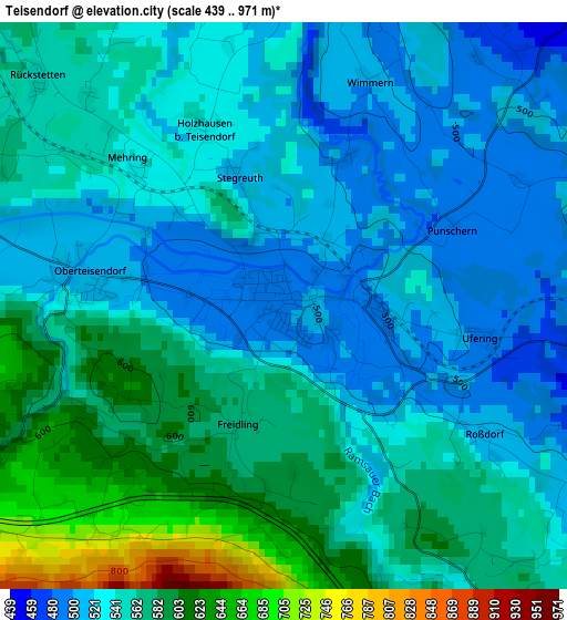
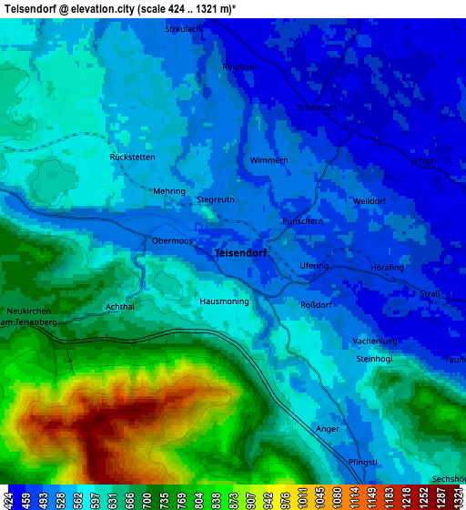
Below is the Elevation map of Teisendorf, which displays elevation range with different colors. Scale of the first map is from 439 to 971 m (1440 to 3186 ft) with average elevation of 550.2 meters (=1805 ft) [note 1]
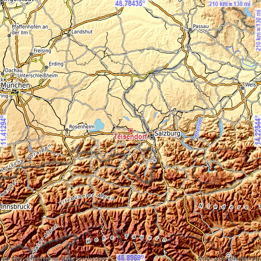
These maps also provides idea of topography and contour of this city, they are displayed at different zoom levels. More info about maps, scale and edge coordinates you can find below images.
| \ | Map #1 | Map #2 | Topo.Map |
| Scale [m] | 439..971 m | 424..1321 m | × |
| Scale [ft] | 1440..3186 ft | 1391..4334 ft | × |
| Average | 550.2 m = 1805 ft | 605.7 m = 1987 ft | × |
| Width | 6.56 km = 4.1 mi | 13.12 km = 8.2 mi | 209.9 km = 130.4 mi |
| Height | 6.56 km = 4.1 mi | 13.12 km = 8.2 mi | 209.9 km = 130.4 mi |
| ↑Max Latitude | 47.878693° | 47.908158° | 48.78435° |
| Latitude at center | 47.84921° | 47.84921° | 47.84921° |
| ↓Min Latitude | 47.819711° | 47.790194° | 46.8969° |
| ← Min Longitude | 12.775245° | 12.731299° | 11.41294° |
| Longitude center | 12.81919° | 12.81919° | 12.81919° |
| →Max Longitude | 12.863135° | 12.907081° | 14.22544° |
Nearby cities:
Cities around Teisendorf sort by population:
• Traunstein elevation 597 m
13.3 km,  279°
279°
• Freilassing 423 m
12.1 km,  94°
94°
• Ainring 439 m
9.9 km,  113°
113°
• Siegsdorf 605 m
13.5 km,  257°
257°
• Laufen 418 m
12.6 km,  40°
40°
• Waging am See 465 m
11.4 km,  326°
326°
• Piding 449 m
11.7 km,  141°
141°
• Inzell 696 m
10.8 km,  207°
207°
• Surberg 599 m
9.1 km, 282°
• Kirchanschöring 417 m
11.6 km,  5°
5°
• Petting 446 m
7 km,  357°
357°
• Sankt Leonhard am Wonneberg 588 m
10.5 km,  314°
314°
Multilingual:
 En español:
Teisendorf elevación 498 m.
 En France:
Teisendorf élévation 498 m.
 Auf Deutsch:
Teisendorf höhe über dem Meeresspiegel ist 498 m.

Sources and notes:
- [note 1] Map square and city borders are not equal. Map elevation data is calculated only from area inside that square.
- [src 1] Elevation data from geonames database provided with same terms of usage.
- [src 2] The elevation map of Teisendorf is generated using elevation data from NASA's 3 arcsec (90m) resolution SRTM data.
- [src 3] Base (background) map © OpenStreetMap contributors tiles are generated by Geofabrik and OpenTopoMap.
Copyright & License:
This Teisendorf Elevation Map is licensed under CC BY-SA. You may reuse any part from this page, if you give a proper credit by linking to this URL:
 More info on terms of use page.