Bad Saarow elevation
Bad Saarow (Brandenburg), Germany elevation is 52 meters and Bad Saarow elevation in feet is 171 ft above sea level [src 1]. Bad Saarow is a seat of a fourth-order administrative division (feature code) with elevation that is 206 meters (676 ft) smaller than average city elevation in Germany.
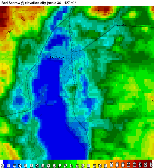
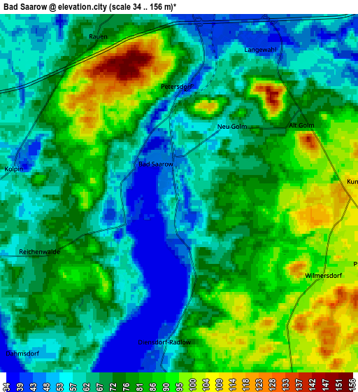
Below is the Elevation map of Bad Saarow, which displays elevation range with different colors. Scale of the first map is from 34 to 127 m (112 to 417 ft) with average elevation of 62.2 meters (=204 ft) [note 1]
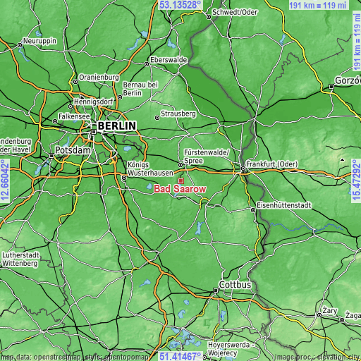
These maps also provides idea of topography and contour of this city, they are displayed at different zoom levels. More info about maps, scale and edge coordinates you can find below images.
| \ | Map #1 | Map #2 | Topo.Map |
| Scale [m] | 34..127 m | 34..156 m | × |
| Scale [ft] | 112..417 ft | 112..512 ft | × |
| Average | 62.2 m = 204 ft | 73.2 m = 240 ft | × |
| Width | 5.98 km = 3.7 mi | 11.96 km = 7.4 mi | 191.3 km = 118.9 mi |
| Height | 5.98 km = 3.7 mi | 11.96 km = 7.4 mi | 191.3 km = 118.9 mi |
| ↑Max Latitude | 52.310206° | 52.337065° | 53.13528° |
| Latitude at center | 52.28333° | 52.28333° | 52.28333° |
| ↓Min Latitude | 52.256438° | 52.22953° | 51.41467° |
| ← Min Longitude | 14.022725° | 13.978779° | 12.66042° |
| Longitude center | 14.06667° | 14.06667° | 14.06667° |
| →Max Longitude | 14.110615° | 14.154561° | 15.47292° |
Nearby cities:
Cities around Bad Saarow sort by population:
• Fürstenwalde elevation 44 m
8.6 km,  357°
357°
• Storkow 39 m
9.5 km,  251°
251°
• Beeskow 46 m
17.3 km,  135°
135°
• Steinhöfel 51 m
14.6 km,  27°
27°
• Rietz Neuendorf 80 m
9.6 km,  130°
130°
• Tauche 56 m
16.3 km,  155°
155°
• Spreenhagen 37 m
14.5 km,  297°
297°
• Briesen 42 m
15.9 km,  64°
64°
• Rauen 70 m
6 km,  334°
334°
• Wendisch Rietz 42 m
8.5 km,  207°
207°
• Reichenwalde 67 m
4.9 km, 247°
• Berkenbrück 41 m
9.3 km,  37°
37°
Multilingual:
 En español:
Bad Saarow elevación 52 m.
 En France:
Bad Saarow élévation 52 m.
 Auf Deutsch:
Bad Saarow höhe über dem Meeresspiegel ist 52 m.

Sources and notes:
- [note 1] Map square and city borders are not equal. Map elevation data is calculated only from area inside that square.
- [src 1] Elevation data from geonames database provided with same terms of usage.
- [src 2] The elevation map of Bad Saarow is generated using elevation data from NASA's 3 arcsec (90m) resolution SRTM data.
- [src 3] Base (background) map © OpenStreetMap contributors tiles are generated by Geofabrik and OpenTopoMap.
Copyright & License:
This Bad Saarow Elevation Map is licensed under CC BY-SA. You may reuse any part from this page, if you give a proper credit by linking to this URL:
 More info on terms of use page.